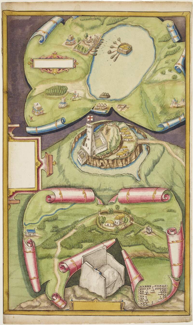
Drawing of Dungannon Castle and the stone chair at Tullaghoge, Co. Tyrone,
circa 1602.
| Main Creator: | |
|---|---|
| Summary: | The lower half of this image is a depiction of Dungannon Castle and surrounding settlements, plus the stone chair at Tullahoge and surrounding areas. The upper half of this picture shows an attack on a crannog in an unspecified location. |
| In collection: | Maps, drawings and plans by Richard Bartlett (Barthelet) and others, 1587-1625. |
| Format: | Manuscript |
| Language: | English |
| Published / Created: |
circa 1602.
|
| Subjects: | |
| Notes: | No scale or annotations are provided on this plan. Physical description: 1 sheet : 25 x 41 cm. more |
| Access: | Original withdrawn. Digitised images are available online. |
| LEADER | 01888ntdaa2200361 u 4500 | ||
|---|---|---|---|
| 001 | vtls000536678 | ||
| 003 | IeDuNL | ||
| 004 | vtls000536659 5 | ||
| 005 | 20150216232100.0 | ||
| 008 | 130708s1602 ie 000 ||eng d | ||
| 039 | 9 | |a 201502162321 |b VLOAD |c 201307120945 |d Samm Coade |c 201307120941 |d Samm Coade |c 201307091533 |d Samm Coade |y 201307081025 |z Samm Coade | |
| 040 | |a IeDuNL |b Description follows NLI guidelines based on ISAD (G)2nd ed. and LCSH | ||
| 049 | 0 | |a MSS | |
| 100 | 1 | |a Bartlett, Richard, |d d. 1603 | |
| 245 | 1 | |a Drawing of Dungannon Castle and the stone chair at Tullaghoge, Co. Tyrone, |f circa 1602. | |
| 260 | |c circa 1602. | ||
| 300 | |a 1 |b sheet : 25 x 41 cm. | ||
| 500 | |a No scale or annotations are provided on this plan. | ||
| 506 | 1 | |a Original withdrawn. Digitised images are available online. | |
| 520 | |a The lower half of this image is a depiction of Dungannon Castle and surrounding settlements, plus the stone chair at Tullahoge and surrounding areas. The upper half of this picture shows an attack on a crannog in an unspecified location. | ||
| 540 | |a Reproduction rights owned by National Library of Ireland. | ||
| 650 | 0 | |a Maps, Manuscript |z Northern Ireland |v Early works to 1800 | |
| 650 | 0 | |a Castles & palaces |z Northern Ireland |z Tyrone | |
| 650 | 0 | |a Tyrone (Northern Ireland : County) |v Maps, Manuscript | |
| 650 | 0 | |a Forts & fortifications |z Northern Ireland |z Tyrone (County) |v Early works to 1800 | |
| 773 | 1 | |i In collection : |t Maps, drawings and plans by Richard Bartlett (Barthelet) and others, 1587-1625. |w (IeDuNL)536659 | |
| 852 | 4 | |a IeDuNL |b MS |c 2656 (5) | |
| 949 | |a VIRTUAITEM |d 40000 |g 40000 |x 24 |a MS 2656 (5) | ||
| 991 | |a IeDuNL (MS_UR_008465) | ||
| 996 | |a true | ||
| 999 | |a VIRTUA | ||
| 999 | |a VTLSSORT0040*0080*0400*0490*1000*2450*2600*3000*5000*5060*5200*5400*6500*6501*6502*6503*7730*8520*9910*9993 | ||
| 999 | |a ANCESTRY |k A536659 |l B536678 | ||


