Showing
1 - 14
results of
14
for search '
Bartlett, Richard, d. 1603
'
Skip to content
Toggle navigation
NLI Website
- Catalogue -
English
Gaeilge
Home
Help
Advanced Search
Browse
Orders
Ask a Librarian
Language
English
Gaeilge
All Fields
Title
Author
Subject
Call Number
ISBN/ISSN
Publisher
Coordinates
Search digitised content only
FIND
Author
Bartlett, Richard, d. 1603
Results
Showing
1 - 14
results of
14
for search '
Bartlett, Richard, d. 1603
'
, query time: 0.04s
List
Grid
Sort
Relevance
Newest First
Oldest First
Call Number
Author
Title
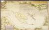
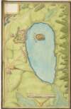
Map of Lough Muckruske and Shannon River, Co. Leitrim,
circa 1602.
Manuscript
Main Creator:
Bartlett
,
Richard
,
d
.
1603
Language:
English
Format:
Manuscript
In collection:
Maps, drawings and plans by Richard Bartlett (Barthelet) and others, 1587-1625.
Published / Created
circa 1602.
Notes
There is no scale provided on this map. Physical desc...
Call Number:
Loading...
Located:
Loading...
View Context
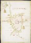
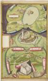
Map of forts in the Lough Neagh area, and showing forts fortified by Tyrone,
circa 1602.
Manuscript
Main Creator:
Bartlett
,
Richard
,
d
.
1603
Language:
English
Format:
Manuscript
In collection:
Maps, drawings and plans by Richard Bartlett (Barthelet) and others, 1587-1625.
Published / Created
circa 1602.
Notes
Scale is given of "20 myles". Physical description:...
Call Number:
Loading...
Located:
Loading...
View Context
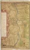
Map and description of Blackwater Valley, showing fortified positions of Irish and English in the O'Neill wars,
circa 1602.
Manuscript
Main Creator:
Bartlett
,
Richard
,
d
.
1603
Language:
English
Format:
Manuscript
In collection:
Maps, drawings and plans by Richard Bartlett (Barthelet) and others, 1587-1625.
Published / Created
circa 1602.
Notes
Scale is marked "scala 500 passuum geometrical". Phys...
Call Number:
Loading...
Located:
Loading...
View Context
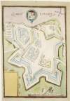
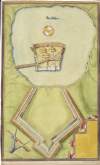
Plan of Mount Norris fort, Co. Armagh, with drawings of cabins,
circa 1602.
Manuscript
Main Creator:
Bartlett
,
Richard
,
d
.
1603
Language:
English
Format:
Manuscript
In collection:
Maps, drawings and plans by Richard Bartlett (Barthelet) and others, 1587-1625.
Published / Created
circa 1602.
Notes
Scale is marked as "scala passuum comnius". Physical...
Call Number:
Loading...
Located:
Loading...
View Context
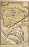
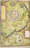
Plan of Armagh City and Mountjoy Fort on the Blackwater river,
circa 1602.
Manuscript
Main Creator:
Bartlett
,
Richard
,
d
.
1603
Language:
English
Format:
Manuscript
In collection:
Maps, drawings and plans by Richard Bartlett (Barthelet) and others, 1587-1625.
Published / Created
circa 1602.
Notes
No scale is provided on this plan. Physical descripti...
Call Number:
Loading...
Located:
Loading...
View Context
Plan of Mountjoy Fort, Lough Sydneye,
circa 1602.
Manuscript
Main Creator:
Bartlett
,
Richard
,
d
.
1603
Language:
English
Format:
Manuscript
In collection:
Maps, drawings and plans by Richard Bartlett (Barthelet) and others, 1587-1625.
Published / Created
c. 1960 reproduction after original map
Notes
Scale is marked as "the scale of 20 yeardes 3 feet to...
Call Number:
Loading...
Located:
Loading...
View Context
Map of the district between Dundalk and Newry,
circa 1602.
Manuscript
Main Creator:
Bartlett
,
Richard
,
d
.
1603
Language:
English
Format:
Manuscript
In collection:
Maps, drawings and plans by Richard Bartlett (Barthelet) and others, 1587-1625.
Published / Created
circa 1602.
Notes
Scale is marked as "Scala milliarium Hiber". Physical...
Call Number:
Loading...
Located:
Loading...
View Context
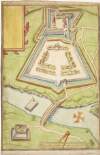
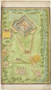
Plan of Charlemont Fort and bridge over the Blackwater river,
circa 1602.
Manuscript
Main Creator:
Bartlett
,
Richard
,
d
.
1603
Language:
English
Format:
Manuscript
In collection:
Maps, drawings and plans by Richard Bartlett (Barthelet) and others, 1587-1625.
Published / Created
circa 1602.
Notes
Scale is marked as "yeardes and paces geom; th'one an...
Call Number:
Loading...
Located:
Loading...
View Context
Plan of Monaghan Fort,
circa 1602.
Manuscript
Main Creator:
Bartlett
,
Richard
,
d
.
1603
Language:
English
Format:
Manuscript
In collection:
Maps, drawings and plans by Richard Bartlett (Barthelet) and others, 1587-1625.
Published / Created
circa 1602.
Notes
Scale is marked 10 yeardes to 6 paces. Physical descr...
Call Number:
Loading...
Located:
Loading...
View Context
Plan of Agher (Augher) Fort, Co. Tyrone,
circa 1602.
Manuscript
Main Creator:
Bartlett
,
Richard
,
d
.
1603
Language:
English
Format:
Manuscript
In collection:
Maps, drawings and plans by Richard Bartlett (Barthelet) and others, 1587-1625.
Published / Created
circa 1602.
Notes
Scale to 40 yeardes is marked. Physical description:...
Call Number:
Loading...
Located:
Loading...
View Context
Maps, drawings and plans by Richard Bartlett (Barthelet) and others,
1587-1625.
Manuscript
Main Creator:
Bartlett
,
Richard
,
d
.
1603
Language:
English
Format:
Manuscript
Published / Created
1587-1625.
Notes
Physical description: 22 items.
Call Number:
Loading...
Located:
Loading...
View Context
Drawing of Dungannon Castle and the stone chair at Tullaghoge, Co. Tyrone,
circa 1602.
Manuscript
Main Creator:
Bartlett
,
Richard
,
d
.
1603
Language:
English
Format:
Manuscript
In collection:
Maps, drawings and plans by Richard Bartlett (Barthelet) and others, 1587-1625.
Published / Created
circa 1602.
Notes
No scale or annotations are provided on this plan. Ph...
Call Number:
Loading...
Located:
Loading...
View Context
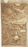
Drawings of attacks on crannogs in Ulster,
circa 1602.
Manuscript
Main Creator:
Bartlett
,
Richard
,
d
.
1603
Language:
English
Format:
Manuscript
In collection:
Maps, drawings and plans by Richard Bartlett (Barthelet) and others, 1587-1625.
Published / Created
circa 1602.
Notes
Scale is marked "scale passuum comunium". Physical de...
Call Number:
Loading...
Located:
Loading...
View Context
Drawing of Enish Loughan fort, Co. Antrim,
circa 1602.
Manuscript
Main Creator:
Bartlett
,
Richard
,
d
.
1603
Language:
English
Format:
Manuscript
In collection:
Maps, drawings and plans by Richard Bartlett (Barthelet) and others, 1587-1625.
Published / Created
circa 1602.
Notes
Scale is marked as "scala passuum". Physical descript...
Call Number:
Loading...
Located:
Loading...
View Context
Get RSS Feed
Email this Search
History
Narrow Search
Digitised
Format
14
Manuscript
Online Availability
13
Digitised
1
Not Digitised
Published / Created
From:
To:
Subject
12
Forts & fortifications
10
Maps, Manuscript
4
Armagh (Northern Ireland : County)
4
Maps and Surveys
3
Tyrone (Northern Ireland : County)
2
Architectural drawings
more ...
1
Bridges
1
Castles & palaces
1
History
1
History, Military
1
Leitrim (Ireland : County)
1
Louth (Ireland : County)
1
Tyrone's Rebellion, 1597-1603
see all ...
less ...
Author
14
Bartlett, Richard, d. 1603
Collections
14
Maps, drawings and plans by Richard Bartlett (Barthelet) and others, 1587-1625.
Language
14
English
Genre
10
Early works to 1800
8
Maps, Manuscript
2
Maps
Era
1
1540?-1616
1
1595-1612
1
16th century
1
17th century
1
Early works to 1800
1
Eraly works to 1800
Region
12
Northern Ireland
5
Ireland
4
Armagh (County)
3
Tyrone (County)
1
Antrim
1
Leitrim (County)
more ...
1
Leitrim (Ireland : County)
1
Louth (County)
1
Monaghan (County)
1
Monaghan (Ireland : County)
1
Tyrone
see all ...
less ...
Loading...