Showing
1 - 4
results of
4
for search '
Longfield, Robert Ormsby, 1844-1908, donor
'
Skip to content
Toggle navigation
NLI Website
- Catalogue -
English
Gaeilge
Home
Help
Advanced Search
Browse
Orders
Ask a Librarian
Language
English
Gaeilge
All Fields
Title
Author
Subject
Call Number
ISBN/ISSN
Publisher
Coordinates
Search digitised content only
FIND
Author
Longfield, Robert Ormsby, 1844-1908, donor
Results
Showing
1 - 4
results of
4
for search '
Longfield, Robert Ormsby, 1844-1908, donor
'
, query time: 0.03s
List
Grid
Sort
Relevance
Newest First
Oldest First
Call Number
Author
Title
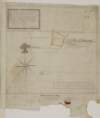
A map of part of the Lands of Glasnevin part of the Estate of the Dean of Christ Church held by John Bayly, copied from a survey made by Richard Francis in the year 1640, and traced out by Thomas Cave in the year 1730. By a scale of 20 Perches to an Inch
Map
Main Creator:
Cave, Thomas, fl. ca. 1709-1749, surveyor
Language:
English
Format:
Map
In collection:
Longfield Map Collection
Published / Created
[1730]
Notes
Physical description: 1 map Geographic Coverage: Bar...
Contributors:
“
...
Longfield
,
Robert
Ormsby
,
1844
-
1908
,
donor
...
”
Call Number:
Loading...
Located:
Loading...
A map [illegible] "This plott of ground is under the High Court of Chancery and belongs to the Vicars Choral of Christ Church Dublin and hath on it three little shops". Surveyed on Dec 1727 by Thos Cave. Scale 10 feet to an inch
Map
Main Creator:
Cave, Thomas, fl. ca. 1709-1749, surveyor
Language:
English
Format:
Map
In collection:
Longfield Map Collection
Published / Created
[December 1727]
Notes
Physical description: 1 map Geographic Coverage: Dub...
Contributors:
“
...
Longfield
,
Robert
Ormsby
,
1844
-
1908
,
donor
...
”
Call Number:
Loading...
Located:
Loading...
A map of the ground plott of the Pall Mill together with four houses fronting to St. Bridgett's Street and three houses fronting to Little Ship Street in the suburbs of the City of Dublin belonging to the Revd. the Dean of Christ Church. Surveyed in January 1743 by Thomas Cave. Scale 20 feet to an inch
Map
Main Creator:
Cave, Thomas, fl. ca. 1709-1749, surveyor
Language:
English
Format:
Map
In collection:
Longfield Map Collection
Published / Created
[January 1743]
Notes
Physical description: 1 map Geographic Coverage: Dub...
Contributors:
“
...
Longfield
,
Robert
Ormsby
,
1844
-
1908
,
donor
...
”
Call Number:
Loading...
Located:
Loading...
A map of a piece of Ground known by the West Moyetie of the Dean's Orchard near Grange Gorman in the subburbs of Dublin belonging to the Dean of Christs Church. Surveyed in August 1730 by Thomas Cave. Scale 10 Perches to an Inch
Map
Main Creator:
Cave, Thomas, fl. ca. 1709-1749, surveyor
Language:
English
Format:
Map
In collection:
Longfield Map Collection
Published / Created
[August 1730]
Notes
Physical description: 1 map Geographic Coverage: Bar...
Contributors:
“
...
Longfield
,
Robert
Ormsby
,
1844
-
1908
,
donor
...
”
Call Number:
Loading...
Located:
Loading...
Get RSS Feed
Email this Search
History
Narrow Search
Digitised
Remove Filters
Clear Filter
Subject: Administration of estates
Clear Filter
Author: Cave, Thomas, fl. ca. 1709-1749, surveyor
Format
4
Map
Online Availability
2
Digitised
2
Not Digitised
Published / Created
From:
To:
Subject
Administration of estates
4
Boundaries (Estates)
4
History
4
Land tenure
4
Land use surveys
Author
Cave, Thomas, fl. ca. 1709-1749, surveyor
Collections
4
Longfield Map Collection
Language
4
English
Genre
4
Early works to 1800
4
Manuscript maps
4
Maps, Manuscript
Era
4
18th century
Region
4
Dublin (County)
4
Dublin (Ireland : County)
4
Ireland
2
Coolock (Barony)
2
Dublin
2
Dublin (Ireland)
Loading...