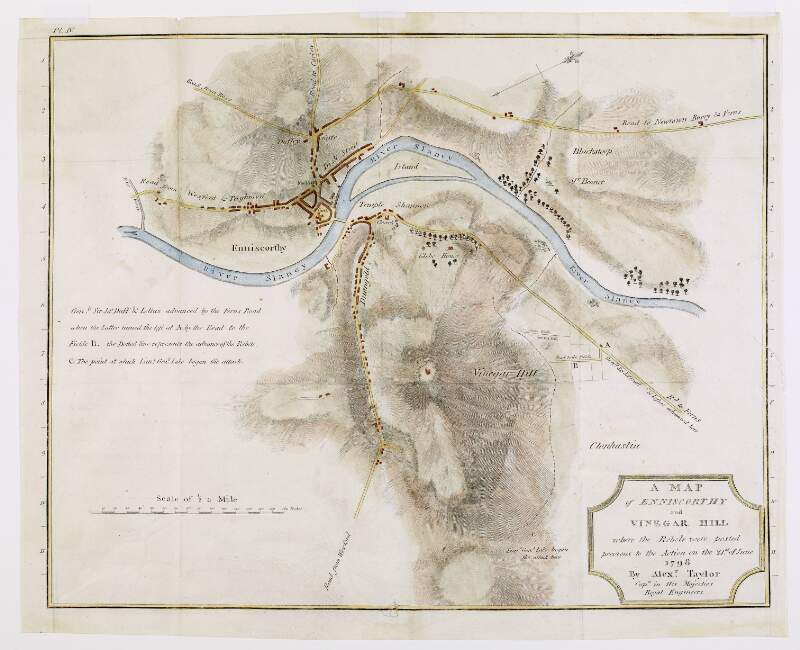
A map of Enniscorthy and Vinegar Hill, where the rebels were posted previous to the action on the 21st of June 1798, by Alexander Taylor, Captain in His Majesties Royal Engineers,
[1798?]
| Main Creator: | |
|---|---|
| Summary: | The map marks the routes by which the government forces and the rebels advanced, and the spot where Lieutenant General Lake began the attack. |
| Format: | Map |
| Language: | English |
| Subjects: | |
| Notes: | Above the scale bar is written 'Scale of 1/2 a mile' and at the end 'Perches'. 40 perches to an inch. Physical description: 1 map : printed and hand coloured ; 37 x 29 cm. Geographic Coverage: Enniscorthy and Vinegar Hill, County Wexford, Ireland, more |
| Arrangement: | Item |
| LEADER | 01696nfmaa2200325 a 4500 | ||
|---|---|---|---|
| 001 | vtls000640125 | ||
| 003 | IeDuNL | ||
| 005 | 20161004163900.0 | ||
| 008 | 150206s1798 ie 000 ||eng d | ||
| 039 | 9 | |a 201610041639 |b Elizabeth Harford |c 201610041636 |d Elizabeth Harford |c 201610041607 |d Elizabeth Harford |c 201502101448 |d Elizabeth Harford |y 201502061645 |z Elizabeth Harford | |
| 040 | |a leDuNL |b eng |e Description follows NLI guidelines based on ISAD(G) 2nd ed. and LCSH | ||
| 041 | 0 | |a eng | |
| 100 | 1 | |a Taylor, Alexander, |d fl. 1766-1830 | |
| 245 | 1 | 2 | |a A map of Enniscorthy and Vinegar Hill, where the rebels were posted previous to the action on the 21st of June 1798, by Alexander Taylor, Captain in His Majesties Royal Engineers, |f [1798?] |
| 255 | |a 40 perches to an inch. | ||
| 300 | |a 1 map : |b printed and hand coloured ; |c 37 x 29 cm. | ||
| 351 | |c Item | ||
| 500 | |a Above the scale bar is written 'Scale of 1/2 a mile' and at the end 'Perches'. | ||
| 520 | 8 | |a The map marks the routes by which the government forces and the rebels advanced, and the spot where Lieutenant General Lake began the attack. | |
| 522 | |a Enniscorthy and Vinegar Hill, County Wexford, Ireland, | ||
| 540 | |a Reproduction rights owned by the National Library of Ireland. | ||
| 650 | 0 | |a Vinegar Hill, Battle of, Wexford, Ireland, 1798 | |
| 650 | 0 | |a Maps | |
| 651 | 0 | |a Ireland |x History |y Rebellion of 1798 |x Campaigns | |
| 651 | 0 | |a Wexford (Ireland : County) |v Maps | |
| 852 | |a IeDuNL |b MS |c MS L 368. | ||
| 949 | |a VIRTUAITEM |d 40000 |f 1 |g 40000 |x 24 |a MS L 368 | ||
| 996 | |a true | ||
| 999 | |a VIRTUA4 | ||
| 999 | |a VTLSSORT0080*0400*0410*1000*2450*2550*3000*3510*5000*5200*5220*5400*5410*6500*6501*6510*6511*8520*9960*9992 | ||

