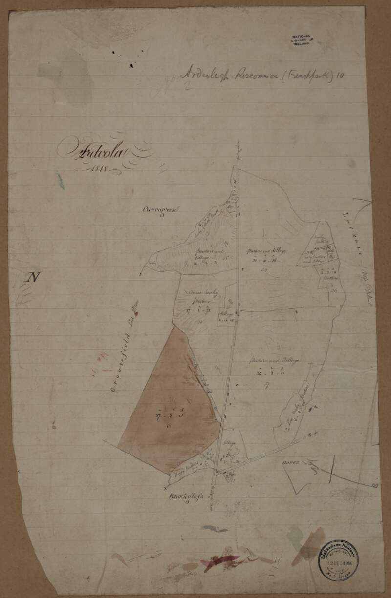
A map of Ardcolagh in the barony of Frenchpark and County of Roscommon. 1818.
| Contributors: | |
|---|---|
| In collection: | Longfield Map Collection |
| Format: | Map |
| Language: | English |
| Published / Created: |
[1818]
|
| Subjects: | |
| Notes: | Physical description: 1 map Geographic Coverage: Barony of Frenchpark, County Roscommon, Province of Connacht, Ireland. more |
| LEADER | 01489nfm a22003611a 4500 | ||
|---|---|---|---|
| 001 | vtls000302473 | ||
| 003 | IeDuNL | ||
| 005 | 20130206185300.0 | ||
| 007 | aj | ||
| 008 | 110727s1818 ie | a 0 e eng|| | ||
| 039 | 9 | |a 201302061853 |b VLOAD |y 201107271805 |z VLOAD | |
| 045 | 0 | |b 1818 | |
| 245 | 0 | 2 | |a A map of Ardcolagh in the barony of Frenchpark and County of Roscommon. 1818. |
| 260 | |c [1818] | ||
| 300 | |a 1 map | ||
| 522 | |a Barony of Frenchpark, County Roscommon, Province of Connacht, Ireland. | ||
| 540 | |a Reproduction rights owned by National Library of Ireland | ||
| 561 | |a Donated by Robert Ormsby Longfield, d. 1908. | ||
| 650 | |a Land use surveys |z Ireland |z Frenchpark (Barony) | ||
| 650 | |a Administration of estates |z Ireland |z Frenchpark (Barony) | ||
| 650 | |a Boundaries (Estates) |z Ireland |z Frenchpark (Barony) | ||
| 650 | |a Land tenure |z Ireland |z Frenchpark (Barony) | ||
| 650 | |a Land use surveys |z Ireland |z Roscommon (County) | ||
| 650 | |a Administration of estates |z Ireland |z Roscommon (County) | ||
| 650 | |a Boundaries (Estates) |z Ireland |z Roscommon (County) | ||
| 650 | |a Land tenure |z Ireland |z Roscommon (County) | ||
| 651 | |a Roscommon (Ireland : County) |v Maps, Manuscript | ||
| 655 | 0 | |a Manuscript maps | |
| 700 | 1 | 0 | |a Longfield, Robert Ormsby, |d 1844-1908, |e donor |
| 773 | 0 | |i In collection: |t Longfield Map Collection |w (IeDuNL)282687 | |
| 852 | |a IeDuNL |b MS |c 21 F. 44 / (070) | ||
| 949 | |a VIRTUAITEM |d 40000 |g 40000 |x 24 |a MS 21 F. 44 / (070) | ||
| 996 | |a true | ||


