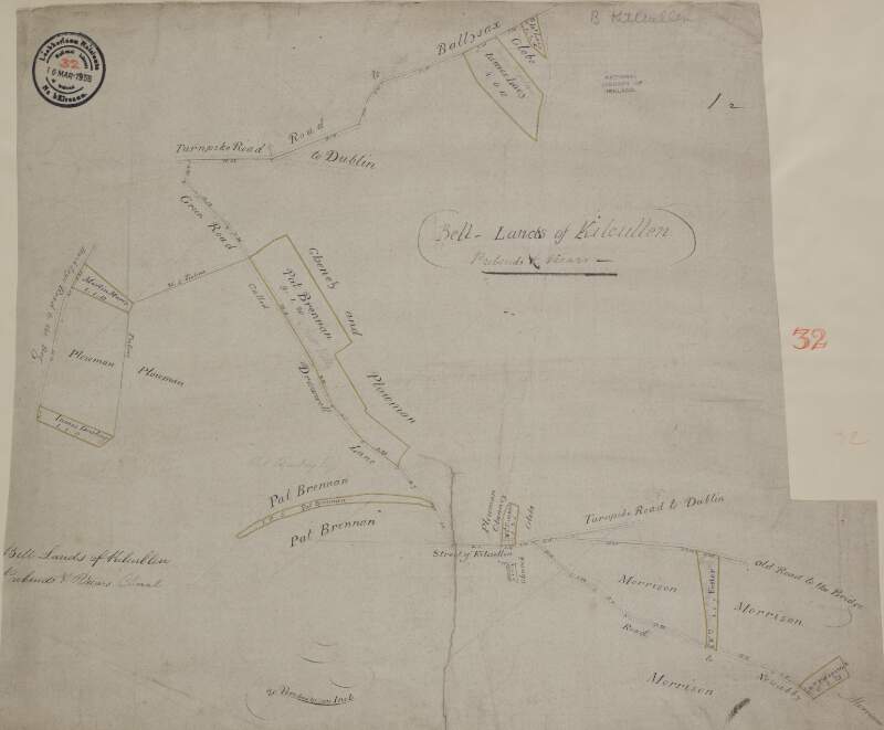
A map of lands at Kilcullen in the barony of Kilcullen & barony of Naas South in County Kildare. Scale 20 perches to an inch. Names of tenants & area of holdings shown.
| Contributors: | |
|---|---|
| In collection: | Longfield Map Collection |
| Format: | Map |
| Language: | English |
| Published / Created: |
[between 1770 and 1840]
|
| Subjects: | |
| Notes: | Physical description: 1 map Geographic Coverage: Barony of Kilcullen, County Kildare, Province of Leinster, Ireland. more |
| LEADER | 01588nfm a22003611a 4500 | ||
|---|---|---|---|
| 001 | vtls000302005 | ||
| 003 | IeDuNL | ||
| 005 | 20130206185000.0 | ||
| 007 | aj | ||
| 008 | 110727q17701840ie | a 0 e eng|| | ||
| 039 | 9 | |a 201302061850 |b VLOAD |y 201107271802 |z VLOAD | |
| 045 | 2 | |b 1770 |b 1840 | |
| 245 | 0 | 2 | |a A map of lands at Kilcullen in the barony of Kilcullen & barony of Naas South in County Kildare. Scale 20 perches to an inch. Names of tenants & area of holdings shown. |
| 260 | |c [between 1770 and 1840] | ||
| 300 | |a 1 map | ||
| 522 | |a Barony of Kilcullen, County Kildare, Province of Leinster, Ireland. | ||
| 540 | |a Reproduction rights owned by National Library of Ireland | ||
| 561 | |a Donated by Robert Ormsby Longfield, d. 1908. | ||
| 650 | |a Land use surveys |z Ireland |z Kilcullen (Barony) | ||
| 650 | |a Administration of estates |z Ireland |z Kilcullen (Barony) | ||
| 650 | |a Boundaries (Estates) |z Ireland |z Kilcullen (Barony) | ||
| 650 | |a Land tenure |z Ireland |z Kilcullen (Barony) | ||
| 650 | |a Land use surveys |z Ireland |z Kildare (County) | ||
| 650 | |a Administration of estates |z Ireland |z Kildare (County) | ||
| 650 | |a Boundaries (Estates) |z Ireland |z Kildare (County) | ||
| 650 | |a Land tenure |z Ireland |z Kildare (County) | ||
| 651 | |a Kildare (Ireland : County) |v Maps, Manuscript | ||
| 655 | 0 | |a Manuscript maps | |
| 700 | 1 | 0 | |a Longfield, Robert Ormsby, |d 1844-1908, |e donor |
| 773 | 0 | |i In collection: |t Longfield Map Collection |w (IeDuNL)282687 | |
| 852 | |a IeDuNL |b MS |c 21 F. 34 / (032) | ||
| 949 | |a VIRTUAITEM |d 40000 |g 40000 |x 24 |a MS 21 F. 34 / (032) | ||
| 996 | |a true | ||


