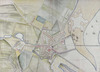
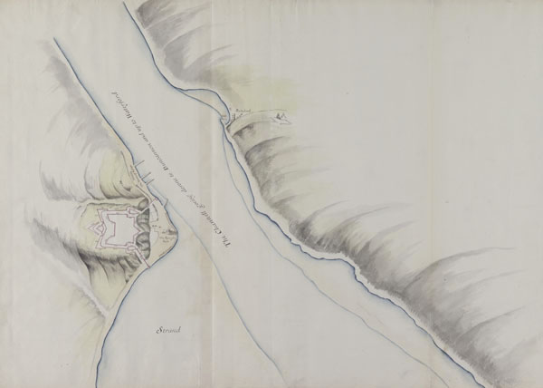
![A ground plott [sic] of the narrow part of ye river, and ye worke designed for the hill over Passage,](http://www.nli.ie/digital/thumbs/vtls000277550.jpg)
A ground plott [sic] of the narrow part of ye river, and ye worke designed for the hill over Passage,
[1685].
| Main Creator: | |
|---|---|
| Contributors: | |
| Summary: | Map of Waterford Harbour, Suir River and plan of the fort for Passage East, County Waterford, Ireland. |
| Format: | Map |
| Language: | English |
| Citation: | National Library of Ireland. Department of Manuscripts. |
| Subjects: | |
| Notes: | "Page 22" inscribed on verso. Executed "By directions of his Majestie King Charles the Second unto ye Right Honble George Lord Dartmouth, Mr General of his Majesties Ordnance in England; and performed by Thomas Phillips. Anno 1685". Originally bound in volume entitled "Rules Orders and Directions for Regulateing [sic] the Office of the Ordnance in Ireland. Together with exact Surveys fo the Cheife [sic] Harbours, Forts, and Fortifications, in the said Kingdom, & Estimates of ye Charge for Fortifying ye most Important Places therein". Physical description: 1 sheet : 20 x 29 inches. Geographic Coverage: Waterford Harbour, Suir River and Passage East, County Waterford, Ireland. more |
| LEADER | 02150nec a22003735 4500 | ||
|---|---|---|---|
| 001 | vtls000277550 | ||
| 003 | IeDuNL | ||
| 005 | 20131218182900.0 | ||
| 008 | 090810s1685 ie b 0 e eng | ||
| 035 | |a 354527 | ||
| 039 | 9 | |a 201312181829 |b VLOAD |c 201008020847 |d VLOAD |y 201005160410 |z VLOAD | |
| 040 | |a IeDuNL | ||
| 049 | |b MSS | ||
| 100 | 1 | |a Phillips, Thomas, |d 1635?-1693 | |
| 245 | 1 | 2 | |a A ground plott [sic] of the narrow part of ye river, and ye worke designed for the hill over Passage, |f [1685]. |
| 300 | |a 1 |b sheet : |c 20 x 29 inches. | ||
| 500 | |a "Page 22" inscribed on verso. | ||
| 500 | |a Executed "By directions of his Majestie King Charles the Second unto ye Right Honble George Lord Dartmouth, Mr General of his Majesties Ordnance in England; and performed by Thomas Phillips. Anno 1685". | ||
| 500 | |a Originally bound in volume entitled "Rules Orders and Directions for Regulateing [sic] the Office of the Ordnance in Ireland. Together with exact Surveys fo the Cheife [sic] Harbours, Forts, and Fortifications, in the said Kingdom, & Estimates of ye Charge for Fortifying ye most Important Places therein". | ||
| 520 | 0 | |a Map of Waterford Harbour, Suir River and plan of the fort for Passage East, County Waterford, Ireland. | |
| 522 | |a Waterford Harbour, Suir River and Passage East, County Waterford, Ireland. | ||
| 524 | 8 | |a National Library of Ireland. Department of Manuscripts. | |
| 650 | 0 | |a Maps |z Ireland |v Early works to 1800 | |
| 650 | 0 | |a Maps, Manuscript |z Ireland |v Early works to 1800 | |
| 651 | 0 | |a Passage East (Ireland) |v Maps |v Early works to 1800 | |
| 651 | 0 | |a Suir River (Ireland) |v Maps |v Early works to 1800 | |
| 651 | 0 | |a Waterford Harbour (Ireland) |v Maps |v Early works to 1800 | |
| 700 | 1 | |a Dartmouth, George Legge, |c Baron, |d 1648-1691 | |
| 852 | 4 | 1 | |a IeDuNL |b MS |c 2557 /8 |
| 856 | 4 | 2 | |u http://www.nli.ie/digital/vtls000277550.jpg |x http://www.nli.ie/digital/thumbs/vtls000277550.jpg |y View image |
| 911 | |a 354527 | ||
| 914 | 7 | 8 | |u http://www.nli.ie/MSS/Phillips/2557(8).htm |x http://www.nli.ie/MSS/Phillips/2557(8)t.jpg |y http |
| 949 | |a VIRTUAITEM |d 40000 |f 1 |g 40000 |x 24 |6 30000000354527 |a MS 2557 /8 | ||
| 955 | |a ACMcG | ||