
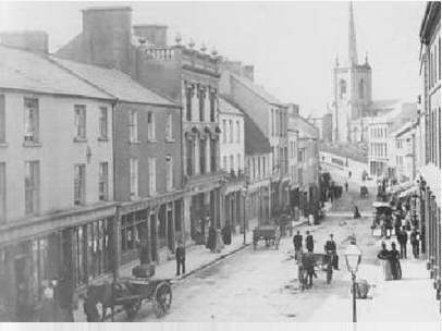
Enniskillen, Co. Fermanagh
[graphic]
| Main Creator: | |
|---|---|
| Contributors: | |
| In collection: | The Lawrence Photograph Collection |
| Format: | Photo |
| Published / Created: |
[between 1880-1900].
|
| Subjects: | |
| Notes: | Additional information about this photograph may be available on the National Library of Ireland's Flickr Commons photostream http://www.flickr.com/photos/nlireland/7595791674/ Robert French was the chief photographer responsible for photographing three quarters of the Lawrence Collection. For more information, see the Dictionary of Irish Biography: http://dib.cambridge.org/viewReadPage.do?articleId=a3369 Physical description: 1 photographic negative glass 16.5 x 21.5 cm. Geographic Coverage: Enniskillen, County Fermanagh, Province of Ulster, Ireland. Caption on glassplate reads: Enniskillen. 1613. W. L. more |

This photo was taken probably by Robert French, chief photographer of William Lawrence Photographic Studios of Dublin.
You can compare this view of Enniskillen with its companion photo taken approximately 100 years later as part of the Lawrence Photographic Project 1990/1991, where one thousand photographs from the Lawrence Collection in the National Library of Ireland were replicated a hundred years later by a team of volunteer photographers, thereby creating a record of the changing face of the selected locations all over Ireland.
For further information on the Lawrence Photographic Project, read all about it on our NLI Blog.
Date: Starting the bidding at 1890... (but definitely after 1885)
NLI Ref.: L_ROY_01613
Tags:
Enniskillen, Fermanagh, Northern Ireland, Ireland, Ulster, Robert French, William Lawrence, Lawrence Collection, Glass Negative, Lawrence Photographic Project, Federation for Ulster Local Studies, F.U.L.S., Federation of Local History Societies, Cathedral, Cole Monument, St. Macartin's, St. Macartin's Cathedral, Inis Ceithleann, Lough Erne, Barracks, Fever Hospital, Militia Barracks, Creden's Stores, Distillery, Chimney, St. Michael's Church, St. Michael's, Enniskillen Brewery, Brewery, Distillery Chimney, Anne Street, West Bridge, McArthur Hall, Town Hall, Dome, Workhouses, National Library of Ireland
Comments

derangedlemur
First! (I have nothing sensible to say).
Posted: 18.07.2012

derangedlemur
Apparently the chancel of St. Macartin's was enlarged in 1889. I can't tell from the photos if that's happened already in the older one though.
Posted: 18.07.2012

derangedlemur
St. Michaels:" Largely built between 1870-75 to just above the belfry – the spire was added more recently. The interior is large and gloomy..."
Posted: 18.07.2012


derangedlemur
The barn on the right. "more recently", incidentally seems to mean mid '90s, so it's not in the other picture either.
Posted: 18.07.2012

Niall McAuley
So, taken from the West bank of the Erne, looking South East towards the memorial, with the Main Barracks over the water.
Posted: 18.07.2012

Niall McAuley
I added notes on some prominent buildings from poking around in the OSNI site, but nothing date-able so far...
Posted: 18.07.2012

Cuddly Nutter
Possiblely taken from grounds of Portora the area has been totally redeveloped even since the companion photo was taken in 1990/1.
Posted: 18.07.2012

Niall McAuley
Taken from somewhere near this green arrow in Google Maps, but there's no streetview thereabouts.
Posted: 18.07.2012

Cuddly Nutter
The West Brridge was built 1885 so we at least have a from date.
Posted: 18.07.2012

dreamer@desh
excellent capture
Posted: 18.07.2012

derangedlemur
The OSNI map from 1858 shows a Vaubanesque bastion immediately south of the main barracks (where the militia barracks is, or possibly in front of it) which is missing in the picture. Assuming the map isn't aspirational, can you find out when it vanished?
Posted: 18.07.2012


derangedlemur
@shanekillen Hasn't been much advance in park bench technology since 1905, has there?
Posted: 18.07.2012


Cuddly Nutter
The main Barracks still appears to be there in this photo www.panoramio.com/photo/53131280
Posted: 18.07.2012

derangedlemur
Here's enniskillen in (allegedly) 1890 from the cathedral website: www.enniskillencathedral.com/images/Ekn1890.JPG. Not a huge amount that matches up besides the spire though.
Posted: 18.07.2012

Cuddly Nutter
Looks like this one's beaten us.
Posted: 18.07.2012


DannyM8
I think I can see the McArthur Hall to the right end of St Michael's Church if I am correct it was built in 1888 so perhaps a new "from date"
Street View of Hall and Church
Posted: 18.07.2012

derangedlemur
@79549245@N06 You're right. If you copy the original size image into an imaging app and do a histogram equalisation on it, the windows are a pretty clear match. A sharpening filter shows it up pretty well too.
Posted: 19.07.2012


derangedlemur
PSP these days. I used to do R&D for medical on space image analysis and compression systems though.
Posted: 19.07.2012

derangedlemur
So why's there no picture today? Has some ill befallen miss National Library?
Posted: 19.07.2012


Cuddly Nutter
Right folks if you look at the middle of the ridge line of St. Michael's you'll see a bump. If you then look at the companion photo which was taken from higher up and a slightly different angle you can see the "bump" is green and is the dome of the Town Hall finished in 1901 !!
Posted: 19.07.2012

derangedlemur
@shanekillen Are you sure? The tower outline is marked on the 1858 town plan. Possibly finished means they got the door completed: www.bbc.co.uk/northernireland/yourplaceandmine/fermanagh/...
Posted: 19.07.2012

Cuddly Nutter
@8468254@N02 www.doeni.gov.uk/niea/fermanagh-2.pdf
Town Hall. Townhall Street, Enniskillen. This imposing building erected 1898 - 1901 was designed by William Scott and built of Carrickreagh stone.
Posted: 19.07.2012

Cuddly Nutter
It would seem we have two conflicting dates for the building of the Town Hall.
Posted: 19.07.2012

derangedlemur
I think we need OS man Niall to adjudicate. I could well be misinterpreting the map date. It's called OS-9-18-2-4(1858 - 1858) from a series called Town Plans Edition 2 (1843-1896). I'm assuming that means it's from 1858 but it may not.
Posted: 19.07.2012

Cuddly Nutter
I think the later of these links rules out 1858 as William Scott wasn't born until 1871.
archiseek.com/2009/1901-ownhall-enniskillen-co-fermanagh/
www.dia.ie/architects/view/4766/SCOTT-WILLIAMALPHONSUS
Posted: 19.07.2012

derangedlemur
Ah. That's a much better picture. You can see that the town hall marked on the map is much smaller, though it includes a tower in the same place. Unless the tower was retained, I think you're correct with your date of 1901.
Edit: Actually, the tower's not in the same place.
Posted: 19.07.2012

Niall McAuley
It looks to me as if there was a town hall on that site in 1858, but it was not the same town hall with the clock-tower which we see today, which was finished in 1901.
Posted: 19.07.2012

Cuddly Nutter
@8468254@N02/ All that because of a litttle bump LOL.
Now we need a before date to narrow it down.
Posted: 19.07.2012

DannyM8
@8468254@N02 @gnmcauley @shanekillen What is the date range now, Im confused (slow) !!
Posted: 19.07.2012


DannyM8
I believe the latest photos in the Lawrence Collection are dated 1914!
Posted: 19.07.2012

derangedlemur
The front face of the main barracks building doesn't match the 1905 map.
Posted: 19.07.2012

Cuddly Nutter
@8468254@N02/ Remember this www.loc.gov/pictures/resource/ppmsc.09884/ if you look to the right of the barracks wall in it you see water, if you look at the same place here it's been filled in some one has got their washing line on it. What does it say it is on the 1905 map? I haven't found a copy of it.

Posted: 19.07.2012

derangedlemur
I think the barrier visible in the picture is present. The water level is different in the two pictures though.
Posted: 19.07.2012

National Library of Ireland on The Commons
Yes, 1914 is definitely the latest possible date.
Posted: 19.07.2012

derangedlemur
It's marked as a river boundary rather than as a wall though. I think the OS expert should interpret it rather than me.
Posted: 19.07.2012

derangedlemur
The barracks does match the 1858 map, so I think you have a latest date of 1905.
Posted: 19.07.2012

Cuddly Nutter
From 1890 to 1901-5 pretty good.
Posted: 19.07.2012

mambo1935
good photo!
Posted: 22.07.2012

whiskyrhythm
Hey Niall and anyone else on here as you guys seem to be up on your local knowledge! Where would I find information on distilleries in Enniskillen. I believe there was the Powell distillery in 1826 possibly run by an excise man Robert Armstrong. Vague details though. I was searching for that and came across Nialls indication of a distillery from an earlier time! Any information on whisky distillation in Enniskillen and fermanagh would be rewarded with a dram!
I'm compiling a historical project based around spirits.
Thanks
Posted: 18.09.2013

National Library of Ireland on The Commons
@gnmcauley You won't get a better offer all year - a dram for information from @97370691@N05! Feel guilty now that I don't offer liquid incentives...
Posted: 19.09.2013

Niall McAuley
@97370691@N05 Not at all a local or an expert, I only know what can be learned from my patented HAGS (Half-Assed Google Search).
This OS map from 1837 shows one distillery at the Erne bridge. On the 1858 map, that building is labelled Ulster Canal Company Stores. There is a Distillery nearby on the Eastern side of the bridge, where the Spar is on streetview. That's the one I highlighted on the photo above.
The topographical dictionary of Ireland of 1837 says: there are two distilleries and a brewery.
Posted: 19.09.2013
whiskyrhythm
Thanks Niall great work. I'm still on the hunt though. Found a guy called Robert Armstrong who was legally producing whiskey in town. Think he was also an excise man.
Dram still stands for any other info from anyone. Or any other photos/pictures that show the roof/chimney/building.
Thanks guys
Posted: 02.10.2013


