Showing
1 - 7
results of
7
for search '
Will, John.
'
Skip to content
Toggle navigation
NLI Website
- Catalogue -
English
Gaeilge
Home
Help
Advanced Search
Browse
Orders
Ask a Librarian
Language
English
Gaeilge
All Fields
Title
Author
Subject
Call Number
ISBN/ISSN
Publisher
Coordinates
Search digitised content only
FIND
Author
Will, John.
Results
Showing
1 - 7
results of
7
for search '
Will, John.
'
, query time: 0.04s
List
Grid
Sort
Relevance
Newest First
Oldest First
Call Number
Author
Title
A map of several lots of ground in the town of Mountmellick part of the Marquis of Drogheda estate. Surveyed by John Longfield, 1819. Scale 4 perches to an inch. Table of reference showing tenants names & area of holdings.
Map
Main Creator:
Longfield,
John
, ca. 1775-1833, surveyor
Language:
English
Format:
Map
In collection:
Longfield Map Collection
Published / Created
[1819]
Notes
Physical description: 1 map Geographic Coverage: Bar...
Call Number:
Loading...
Located:
Loading...
A map of the lands of Lismore, the estate of William Carden, and adjoining townlands in the parish of Aghaboe and barony of Clandonagh surveyed to ascertain the bounds of lands between the Duchens of Chandos and William Carden by John Longfield 1809.
Map
Main Creator:
Longfield,
John
, ca. 1775-1833, surveyor
Language:
English
Format:
Map
In collection:
Longfield Map Collection
Published / Created
[1809].
Notes
Physical description: 1 map Geographic Coverage: Par...
Call Number:
Loading...
Located:
Loading...
A survey of the lands of Killeen in the barony of Ballyadams and Queens [Leix] County, the estate of A. F. St. George, done for Mrs. Warren by J Longfield. Feb 1808. Scale 20 perches to an inch.
Map
Main Creator:
Longfield,
John
, ca. 1775-1833, surveyor
Language:
English
Format:
Map
In collection:
Longfield Map Collection
Published / Created
[February 1808]
Notes
Physical description: 1 map Geographic Coverage: Bar...
Call Number:
Loading...
Located:
Loading...
A survey of part of the lands of Shanahoe and Killeany in the barony of Maryborough West and Queen's [Leix] County purchased by H.H. Bawne Surveyed by J.L. 1815. Names of tenants & acreage of holdings shown.
Map
Main Creator:
Longfield,
John
, ca. 1775-1833, surveyor
Language:
English
Format:
Map
In collection:
Longfield Map Collection
Published / Created
[1815]
Notes
Physical description: 1 map Geographic Coverage: Cou...
Call Number:
Loading...
Located:
Loading...
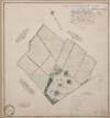
A survey of the lands of Killabin [Killabban] in the barony of Ballyadams and Queens County the estate of Arthur French St. George done by John Longfield. 1808. Names of tenants & acreage of holdings shown.
Map
Main Creator:
Longfield,
John
, ca. 1775-1833, surveyor
Language:
English
Format:
Map
In collection:
Longfield Map Collection
Published / Created
[1808]
Notes
Physical description: 1 map Geographic Coverage: Bar...
Call Number:
Loading...
Located:
Loading...
A map of the demense of Ashfield in the barony of Portnahinch and Queens County let by the Revd. Dean French to Capt. Archdall. Surveyed by John Longfield. 1817. Scale 10 perches to an inch. Table of contents.
Map
Main Creator:
Longfield,
John
, ca. 1775-1833, surveyor
Language:
English
Format:
Map
In collection:
Longfield Map Collection
Published / Created
[1817]
Notes
Physical description: 1 map Geographic Coverage: Bar...
Call Number:
Loading...
Located:
Loading...
A map of the demense of Ashfield in the barony of Portnahinch and Queens [Leix] County let by the Reverend Dean French to Capt. Archdall. Surveyed by J.L. March 1817. Scale 10 perches to an inch. Table of contents.
Map
Main Creator:
Longfield,
John
, ca. 1775-1833, surveyor
Language:
English
Format:
Map
In collection:
Longfield Map Collection
Published / Created
[March 1817]
Notes
Physical description: 1 map Geographic Coverage: Bar...
Call Number:
Loading...
Located:
Loading...
Get RSS Feed
Email this Search
History
Narrow Search
Digitised
Remove Filters
Clear Filter
Author: Longfield, John, ca. 1775-1833, surveyor
Clear Filter
Region: Laois (Ireland)
Format
7
Map
Online Availability
7
Digitised
Published / Created
From:
To:
Subject
7
Administration of estates
7
Boundaries (Estates)
7
Land tenure
7
Land use surveys
Author
Longfield, John, ca. 1775-1833, surveyor
Collections
7
Longfield Map Collection
Language
7
English
Genre
7
Manuscript maps
7
Maps, Manuscript
Region
7
Ireland
7
Laois
Laois (Ireland)
3
Portnahinch (Barony)
2
Ballyadams (Barony)
1
Aghaboe Parish
more ...
1
Aghahoe Parish (Ireland)
1
Clandonagh (Barony)
see all ...
less ...
Loading...
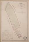
![A survey of the lands of Killeen in the barony of Ballyadams and Queens [Leix] County, the estate of A. F. St. George, done for Mrs. Warren by J Longfield. Feb 1808. Scale 20 perches to an inch.](/IIIF/000310000/000302565/vtls000302565_001.jp2/full/100,/0/default.jpg)
![A survey of part of the lands of Shanahoe and Killeany in the barony of Maryborough West and Queen's [Leix] County purchased by H.H. Bawne Surveyed by J.L. 1815. Names of tenants & acreage of holdings shown.](/IIIF/000310000/000302379/vtls000302379_001.jp2/full/100,/0/default.jpg)
![A survey of the lands of Killabin [Killabban] in the barony of Ballyadams and Queens County the estate of Arthur French St. George done by John Longfield. 1808. Names of tenants & acreage of holdings shown.](/IIIF/000310000/000302371/vtls000302371_001.jp2/full/100,/0/default.jpg)
![A map of the demense of Ashfield in the barony of Portnahinch and Queens [Leix] County let by the Reverend Dean French to Capt. Archdall. Surveyed by J.L. March 1817. Scale 10 perches to an inch. Table of contents.](/IIIF/000310000/000302387/vtls000302387_001.jp2/full/100,/0/default.jpg)