Showing
1 - 16
results of
16
for search '
Will, John.
'
Skip to content
Toggle navigation
NLI Website
- Catalogue -
English
Gaeilge
Home
Help
Advanced Search
Browse
Orders
Ask a Librarian
Language
English
Gaeilge
All Fields
Title
Author
Subject
Call Number
ISBN/ISSN
Publisher
Coordinates
Search digitised content only
FIND
Author
Will, John.
Results
Showing
1 - 16
results of
16
for search '
Will, John.
'
, query time: 0.05s
List
Grid
Sort
Relevance
Newest First
Oldest First
Call Number
Author
Title
A map of Ballinealoe and Williamstown in the barony of Fore and County of Westmeath, the estate of Thomas Smyth. By J.B. March 1781.
Map
Main Creator:
Brownrigg,
John
, ca. 1748-1838, surveyor
Language:
English
Format:
Map
In collection:
Longfield Map Collection
Published / Created
[1781]
Notes
Inset map: "A map of several lots of ground lying bet...
Call Number:
Loading...
Located:
Loading...
A map of the new Line of street called Hatch Street and also of the continuation of Harcourt Street to the Circular Road, belonging to Robt. Watson Wade & Edwd. Whitten Esq. Laid out for Building by Jn.. Brownrigg 1791. Scale 40 Feet to an Inch.
Map
Main Creator:
Brownrigg,
John
, ca. 1748-1838, surveyor
Language:
English
Format:
Map
In collection:
Longfield Map Collection
Published / Created
[1791]
Notes
Physical description: 1 map Geographic Coverage: Dub...
Call Number:
Loading...
Located:
Loading...
A map of part of the Farm of St. Sepulchres in the County of Dublin held under his Grace Robt. Lord Archbishop of Dublin by Wm. Thomas Esq. Survey'd by John Brownrigg 1795. Scale 80 Feet to an Inch
Map
Main Creator:
Brownrigg,
John
, ca. 1748-1838, surveyor
Language:
English
Format:
Map
In collection:
Longfield Map Collection
Published / Created
[1795]
Notes
Physical description: 1 map Geographic Coverage: Bar...
Call Number:
Loading...
Located:
Loading...
A survey of a holding in Mary's Abbey belonging [to] Mrs. Mazier. April 1798. By J.B.
Map
Main Creator:
Brownrigg,
John
, ca. 1748-1838, surveyor
Language:
English
Format:
Map
In collection:
Longfield Map Collection
Published / Created
[April 1798]
Notes
Physical description: 1 map Geographic Coverage: Dub...
Call Number:
Loading...
Located:
Loading...
A map of a Lott of Building ground in the Lordship of Mary's Abbey and County of Dublin belonging to Mr. William Crosby. Survey'd by J. Brownrigg March 1789
Map
Main Creator:
Brownrigg,
John
, ca. 1748-1838, surveyor
Language:
English
Format:
Map
In collection:
Longfield Map Collection
Published / Created
[March 1789]
Notes
Physical description: 1 map Geographic Coverage: Dub...
Call Number:
Loading...
Located:
Loading...
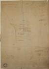
A map of Fyagh [Feagh] in the barony of Kells Lower and County of Meath, the estate of Thomas Bligh. Surveyed in September 1787 by J.B.
Map
Main Creator:
Brownrigg,
John
, ca. 1748-1838, surveyor
Language:
English
Format:
Map
In collection:
Longfield Map Collection
Published / Created
[1787-1788]
Notes
Inset map: "A map of a piece of ground on the west si...
Call Number:
Loading...
Located:
Loading...
A survey of a holding at St. Stephen's Green held by Mr. Thomas Glynn under Peter Digges Latouche Esq. Done by John Brownrigg Nov 23 1787. Scale 20 Feet to an Inch
Map
Main Creator:
Brownrigg,
John
, ca. 1748-1838, surveyor
Language:
English
Format:
Map
In collection:
Longfield Map Collection
Published / Created
[November 23 1787]
Notes
Physical description: 1 map Geographic Coverage: Dub...
Call Number:
Loading...
Located:
Loading...
A map of Eight Lots of Building ground in Frederick Street and in the County of the City of Dublin. By J. Longfield 1816
Map
Main Creator:
Longfield,
John
, ca. 1775-1833, surveyor
Language:
English
Format:
Map
In collection:
Longfield Map Collection
Published / Created
[1816]
Notes
Physical description: 1 map Geographic Coverage: Dub...
Call Number:
Loading...
Located:
Loading...
A map of a Holding [No.17] on the North side of Cook St in the City of Dublin, let by [illegible] Ball Esq. to Mr. Egan. Surveyed by J. Longfield Dec 1809
Map
Main Creator:
Longfield,
John
, ca. 1775-1833, surveyor
Language:
English
Format:
Map
In collection:
Longfield Map Collection
Published / Created
[December 1809]
Notes
Physical description: 1 map Geographic Coverage: Dub...
Call Number:
Loading...
Located:
Loading...
A survey of George Paul Monk Esq holding at St Stephen's Green done for [illegible] Mitchell Esq. by John Brownrigg Aug 11 1787
Map
Main Creator:
Brownrigg,
John
, ca. 1748-1838, surveyor
Language:
English
Format:
Map
In collection:
Longfield Map Collection
Published / Created
[August 11 1787]
Notes
Physical description: 1 map Geographic Coverage: Dub...
Call Number:
Loading...
Located:
Loading...
A survey of part of the lands of Baggots Rath for Francis Thomas Russell. By John Longfield May 1824. Scale 10 perches to an inch. Mr Haig's holding shown.
Map
Main Creator:
Longfield,
John
, ca. 1775-1833, surveyor
Language:
English
Format:
Map
In collection:
Longfield Map Collection
Published / Created
[May 1824]
Notes
Physical description: 1 map Geographic Coverage: Dub...
Call Number:
Loading...
Located:
Loading...
A map of a lot of ground on the north side of Sheriff Street in the City of Dublin done for James Williams by John Longfield 1815. Adjoining names shown
Map
Main Creator:
Longfield,
John
, ca. 1775-1833, surveyor
Language:
English
Format:
Map
In collection:
Longfield Map Collection
Published / Created
[1815]
Notes
Physical description: 1 map Geographic Coverage: Dub...
Call Number:
Loading...
Located:
Loading...
[A plan of holdings at] Johnmills in the Barony of Uppercross Co Dublin belonging to John Gilmore Esq. by J.B. 1774.
Map
Main Creator:
Brownrigg,
John
, ca. 1748-1838, surveyor
Language:
English
Format:
Map
In collection:
Longfield Map Collection
Published / Created
[1774]
Notes
Inset map: "A plan showing Temple Street and Stable L...
Call Number:
Loading...
Located:
Loading...
A map of a holding on the East side of Aungier St. In the City of Dublin, known by the name Ram Inn belonging to Mr. Philip Martin. Surveyed by Brownrigg, Longfield & Murray 1800.
Map
Main Creator:
Brownrigg, Longfield and Murray, fl. 1799-ca. 1805, surveyors
Language:
English
Format:
Map
In collection:
Longfield Map Collection
Published / Created
[1800]
Notes
Physical description: 1 map Geographic Coverage: Dub...
Contributors:
“
...Longfield,
John
, ca. 1775-1833, surveyor...
”
Call Number:
Loading...
Located:
Loading...
A map of a piece of ground at Booterstown in the County of Dublin. Surveyed for Counr. Caldbeck by Brownrigg & Co. 1801. Scale 40 Feet to an Inch.
Map
Main Creator:
Brownrigg & Co., fl. 1801-1809, surveyors
Language:
English
Format:
Map
In collection:
Longfield Map Collection
Published / Created
[1801]
Notes
Inset map: "A map of a holding on the East side of Pa...
Contributors:
“
...Brownrigg,
John
, ca. 1748-1838, surveyor...
”
Call Number:
Loading...
Located:
Loading...
A map of part of the Precincts of St John without Newgate Dublin, the Estate of Thomas & Ralph Smith Esq. By Brownrigg & Sherrard 1778
Map
Main Creator:
Brownrigg & Sherrard, fl. 1777-1778, surveyors
Language:
English
Format:
Map
In collection:
Longfield Map Collection
Published / Created
[1778]
Notes
Physical description: 1 map Geographic Coverage: Dub...
Contributors:
“
...Brownrigg,
John
, ca. 1748-1838, surveyor...
”
Call Number:
Loading...
Located:
Loading...
Get RSS Feed
Email this Search
History
Narrow Search
Digitised
Remove Filters
Clear Filter
Region: Dublin City (Barony)
Clear Filter
Subject: Boundaries (Estates)
Format
16
Map
Online Availability
12
Not Digitised
4
Digitised
Published / Created
From:
To:
Subject
16
Administration of estates
Boundaries (Estates)
16
Land tenure
16
Land use surveys
11
History
Author
9
Brownrigg, John, ca. 1748-1838, surveyor
4
Longfield, John, ca. 1775-1833, surveyor
1
Brownrigg & Co., fl. 1801-1809, surveyors
1
Brownrigg & Sherrard, fl. 1777-1778, surveyors
1
Brownrigg, Longfield and Murray, fl. 1799-ca. 1805, surveyors
Collections
16
Longfield Map Collection
Language
16
English
Genre
16
Manuscript maps
16
Maps, Manuscript
11
Early works to 1800
Era
11
18th century
Region
16
Dublin (Ireland : County)
Dublin City (Barony)
16
Ireland
15
Dublin (County)
15
Dublin (Ireland)
12
Dublin
more ...
1
Dublin (Barony)
1
Dublin City
1
Dublin City (Barony))
1
Fore (Barony)
1
Kells Lower (Barony)
1
Meath
1
Meath (Ireland)
1
Rathdown (Barony)
1
Uppercross (Barony)
1
Westmeath
1
Westmeath (Ireland)
see all ...
less ...
Loading...
![A map of Fyagh [Feagh] in the barony of Kells Lower and County of Meath, the estate of Thomas Bligh. Surveyed in September 1787 by J.B.](/IIIF/000310000/000301785/vtls000301785_001.jp2/full/100,/0/default.jpg)

