Showing
61 - 80
results of
526
for search '
Will, John.
'
Skip to content
Toggle navigation
NLI Website
- Catalogue -
English
Gaeilge
Home
Help
Advanced Search
Browse
Orders
Ask a Librarian
Language
English
Gaeilge
All Fields
Title
Author
Subject
Call Number
ISBN/ISSN
Publisher
Coordinates
Search digitised content only
FIND
Author
Will, John.
Results
Showing
61 - 80
results of
526
for search '
Will, John.
'
, query time: 0.05s
List
Grid
Sort
Relevance
Newest First
Oldest First
Call Number
Author
Title
1
Previous
1
2
3
4
5
6
7
8
9
10
11
Next
27
A map of two Holdings in the street of Tallaght in the County of Dublin belonging to Mr. Anthy. Cleval by J. Brownrigg 1797. Scale Eight Perches to an Inch
Map
Main Creator:
Brownrigg,
John
, ca. 1748-1838, surveyor
Language:
English
Format:
Map
In collection:
Longfield Map Collection
Published / Created
[1797]
Notes
Physical description: 1 map Geographic Coverage: Bar...
Call Number:
Loading...
Located:
Loading...
A map of Part of the Lands of Rathfarnham Surveyed for Mr. Moore by J.L. 1812. Scale 10 Perches to an Inch
Map
Main Creator:
Longfield,
John
, ca. 1775-1833, surveyor
Language:
English
Format:
Map
In collection:
Longfield Map Collection
Published / Created
[1812]
Notes
Physical description: 1 map Geographic Coverage: Bar...
Call Number:
Loading...
Located:
Loading...
A map of a holding on the north side of Summer Hill in the City of Dublin the propety of Mr. Wood. Surveyed by J.B. 1792. Names of adjoining tenants shown
Map
Main Creator:
Brownrigg,
John
, ca. 1748-1838, surveyor
Language:
English
Format:
Map
In collection:
Longfield Map Collection
Published / Created
[1792]
Notes
Physical description: 1 map Geographic Coverage: Dub...
Call Number:
Loading...
Located:
Loading...
A survey of the Lands of Furry Hill, a subdenomination of Balally in the County of Dublin done in 1777 by John Connor and copied 1782 by John Brownrigg. Scale 10 Perches to an Inch
Map
Main Creator:
Brownrigg,
John
, ca. 1748-1838, surveyor
Language:
English
Format:
Map
In collection:
Longfield Map Collection
Published / Created
[1782]
Notes
Physical description: 1 map Geographic Coverage: Bar...
Contributors:
“
...Connor,
John
, fl. 1774-1778, surveyor...
”
Call Number:
Loading...
Located:
Loading...
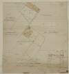
A survey of the lands of Ballinlig and Cornamucklagh [near Clonard] in the barony of Carbury and County of Kildare part of the estate of Lady Jane Loftus. By J. Longfield. June 1819. Some tenants names shown on holdings
Map
Main Creator:
Longfield,
John
, ca. 1775-1833, surveyor
Language:
English
Format:
Map
In collection:
Longfield Map Collection
Published / Created
[June 1819]
Notes
Damaged, with some tears and creases. Some staining i...
Call Number:
Loading...
Located:
Loading...
A survey of a holding at St. Stephen's Green held by Mr. Thomas Glynn under Peter Digges Latouche Esq. Done by John Brownrigg Nov 23 1787. Scale 20 Feet to an Inch
Map
Main Creator:
Brownrigg,
John
, ca. 1748-1838, surveyor
Language:
English
Format:
Map
In collection:
Longfield Map Collection
Published / Created
[November 23 1787]
Notes
Physical description: 1 map Geographic Coverage: Dub...
Call Number:
Loading...
Located:
Loading...
A map of several pieces of ground call'd the Castle Farm near Swords in the County of Dublin. Survey'd for Sr. Sl. Synge Hutchinson Esq by J. L. 1806. Scale 20 Perches to an Inch,
Map
Main Creator:
Longfield,
John
, ca. 1775-1833, surveyor
Language:
English
Format:
Map
In collection:
Longfield Map Collection
Published / Created
[1806]
Notes
Physical description: 1 map Geographic Coverage: Bar...
Call Number:
Loading...
Located:
Loading...
A map of the Line intended for the Royal Canal from Ashtown to Barberstown in the County of Dublin, as laid out by Richd. Evans Enginr. Surveyed by J. Brownrigg. 1791. Scale 500 Feet to an Inch
Map
Main Creator:
Brownrigg,
John
, ca. 1748-1838, surveyor
Language:
English
Format:
Map
In collection:
Longfield Map Collection
Published / Created
[1791]
Notes
Physical description: 1 map Geographic Coverage: Bar...
Call Number:
Loading...
Located:
Loading...
A survey of three houses in Queen Street part of the estate of the Marquis of Lansdowne. Surveyed by John Longfield 1827. Names of tenants shown on properties.
Map
Main Creator:
Longfield,
John
, ca. 1775-1833, surveyor
Language:
English
Format:
Map
In collection:
Longfield Map Collection
Published / Created
[1827]
Notes
Physical description: 1 map Geographic Coverage: Dub...
Call Number:
Loading...
Located:
Loading...
A map of the manor of Clare in the County of Armagh & Kingdom of Ireland, the Estate of the Rt. Honourable John Earl of Sandwich & Peter De Sales Esq. Reduced from R. Brassingtons survey by Jn.. Longfield, 1805.
Map
Main Creator:
Longfield,
John
, ca. 1775-1833, surveyor
Language:
English
Format:
Map
In collection:
Longfield Map Collection
Published / Created
[1805]
Notes
Physical description: 1 map Geographic Coverage: Par...
Call Number:
Loading...
Located:
Loading...
[A map showing part of Bushy Park and the Lands of Butterfield & Synge Esq in the County Dublin] a dotted line indicates the bed of the river in 1782 according to a survey made by Mr. Brownrigg. Scale 10 Perches to an Inch
Map
Main Creator:
Brownrigg,
John
, ca. 1748-1838, surveyor
Language:
English
Format:
Map
In collection:
Longfield Map Collection
Published / Created
[1782]
Notes
Physical description: 1 map Geographic Coverage: Bar...
Call Number:
Loading...
Located:
Loading...
Longitudinal and transverse sections of that part of the river Blackwater adjoining the lands of Mullaghard Rathaldron and Liscartan in the County of Meath. Surveyed by John Long under the direction of William F. Mulvany C.E.
Map
Main Creator:
Longfield,
John
, ca. 1775-1833, surveyor
Language:
English
Format:
Map
In collection:
Longfield Map Collection
Published / Created
[between 1795 and 1833]
Notes
For other sections of the river Blackwater see MS 21...
Call Number:
Loading...
Located:
Loading...
A map of two holdings on the north side of St Stephens Green in the City of Dublin. Surveyed by John Longfield 1833. Names of tenants shown on properties and adjoining tenants shown.
Map
Main Creator:
Longfield,
John
, ca. 1775-1833, surveyor
Language:
English
Format:
Map
In collection:
Longfield Map Collection
Published / Created
[1833]
Notes
Physical description: 1 map Geographic Coverage: Dub...
Call Number:
Loading...
Located:
Loading...
A survey of part of the Lands of Springfield and part of Butterfield in the County of Dublin the property of W Middlewood by John Brownrigg, 1795. Scale 20 Perches to an Inch
Map
Main Creator:
Brownrigg,
John
, ca. 1748-1838, surveyor
Language:
English
Format:
Map
In collection:
Longfield Map Collection
Published / Created
[1795]
Notes
Physical description: 1 map Geographic Coverage: Bar...
Call Number:
Loading...
Located:
Loading...
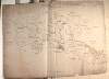
A survey of part of the estate of John Pollock situate in the barony of Lower Kells and County of Meath [at Tullyatten...] By J.L. 1805. Names of tenants & acreage of holdings shown.
Map
Main Creator:
Longfield,
John
, ca. 1775-1833, surveyor
Language:
English
Format:
Map
In collection:
Longfield Map Collection
Published / Created
[1805]
Notes
Physical description: 1 map Geographic Coverage: Bar...
Call Number:
Loading...
Located:
Loading...
A map of the Grange of Balscaddin in the Barony of Balrothery & County of Dublin - the Estate of the Dean of Christ Church. Surveyed by J.L. 1823.
Map
Main Creator:
Longfield,
John
, ca. 1775-1833, surveyor
Language:
English
Format:
Map
In collection:
Longfield Map Collection
Published / Created
[1823]
Notes
Physical description: 1 map Geographic Coverage: Bar...
Call Number:
Loading...
Located:
Loading...
A map of part of the Lands of Crumlin in the County of Dublin. The Estate of the Dean & Chapter of Christ Church let to [illegible]. Survey'd by Jn.. Longfield 1805. Scale 20 Perches to an Inch
Map
Main Creator:
Longfield,
John
, ca. 1775-1833, surveyor
Language:
English
Format:
Map
In collection:
Longfield Map Collection
Published / Created
[1805]
Notes
Physical description: 1 map Geographic Coverage: Bar...
Call Number:
Loading...
Located:
Loading...
A map of a Proposed Line of New Road, to shorten the carriage way from Ballsbridge to the new Church and Bridge of Donnybrook in the County of Dublin. Surveyed and laid out by John Longfield in April 1828. Scale 10 Perches to an Inch
Map
Main Creator:
Longfield,
John
, ca. 1775-1833, surveyor
Language:
English
Format:
Map
In collection:
Longfield Map Collection
Published / Created
[April 1828]
Notes
Physical description: 1 map Geographic Coverage: Bar...
Call Number:
Loading...
Located:
Loading...
A map of Bay View & Mount Pleasant in the Barony of Coolock & County of Dublin belonging to Robt. Burton Esq. Surveyed by J. Brownrigg 1792. Scale 10 Perches to an Inch
Map
Main Creator:
Brownrigg,
John
, ca. 1748-1838, surveyor
Language:
English
Format:
Map
In collection:
Longfield Map Collection
Published / Created
[1792]
Notes
Physical description: 1 map Geographic Coverage: Bar...
Call Number:
Loading...
Located:
Loading...
A map of Part of the Lands of Churchtown in the Co Dublin, the property of Mr. Leasam. Survey'd by J. Longfield 1819. Scale 10 Perches to an Inch.
Map
Main Creator:
Longfield,
John
, ca. 1775-1833, surveyor
Language:
English
Format:
Map
In collection:
Longfield Map Collection
Published / Created
[1819]
Notes
Physical description: 1 map Geographic Coverage: Bar...
Call Number:
Loading...
Located:
Loading...
1
Previous
1
2
3
4
5
6
7
8
9
10
11
Next
27
Get RSS Feed
Email this Search
History
Narrow Search
Digitised
Remove Filters
Clear Filter
Genre: Maps, Manuscript
Clear Filter
Subject: Boundaries (Estates)
Format
526
Map
Online Availability
264
Digitised
262
Not Digitised
Published / Created
From:
To:
Subject
Boundaries (Estates)
526
Land tenure
526
Land use surveys
516
Administration of estates
126
History
19
Administration of Estates
Author
335
Longfield, John, ca. 1775-1833, surveyor
112
Brownrigg, John, ca. 1748-1838, surveyor
42
Brownrigg & Co., fl. 1801-1809, surveyors
7
Brownrigg, Longfield and Murray, fl. 1799-ca. 1805, surveyors
6
Longfield, William, fl. 1825-ca. 1870, surveyor
4
Scalé, Brownrigg & Sherrard, fl. 1774-1778, surveyors
more ...
3
Roe, John, fl. 1793-1824, surveyor
2
Brownrigg & Sherrard, fl. 1777-1778, surveyors
2
Byrne, John, fl. 1789-1828, surveyor
2
Moynahan, John, fl. 1736-1764, surveyor
1
Balfe, M., fl. 1821, surveyor
1
Battersby, John, fl. 1778, surveyor
1
Bell, John (I and II), fl. 1721-1820
1
Browne, John, fl. 1788-ca. 1807, surveyor
1
Connolly, John, fl. 1826, surveyor
1
Kelly, John, fl. 1820-1852, surveyor
1
Logan, John, fl. 1827-1846, surveyor
1
Molloy, John, fl. 1809-1839, surveyor
1
Netterville, John, fl. 1747-1768, surveyor
1
O'Brien, John, fl. 1784-1820, surveyor
1
Wright, John, fl. 1759-1775, surveyor
see all ...
less ...
Collections
526
Longfield Map Collection
Language
526
English
Genre
526
Manuscript maps
Maps, Manuscript
126
Early works to 1800
Era
126
18th century
Region
522
Ireland
321
Dublin (Ireland : County)
320
Dublin (County)
130
Dublin (Ireland)
127
Dublin
58
Meath
more ...
58
Meath (Ireland)
57
Rathdown (Barony)
49
Kildare (County)
49
Kildare (Ireland : County)
40
Coolock (Barony)
27
Uppercross (Barony)
21
Newcastle (Barony)
18
Offaly West (Barony)
17
Dublin (Barony)
16
Castleknock (Barony)
16
Dublin City (Barony)
16
Nethercross (Barony)
13
Wicklow (County)
13
Wicklow (Ireland : County)
12
Westmeath
12
Westmeath (Ireland)
11
Balrothery (Barony)
10
Roscommon (County)
10
Roscommon (Ireland : County)
9
Duleek Upper (Barony)
9
Laois
9
Laois (Ireland)
8
Tipperary (County)
8
Tipperary (Ireland : County)
see all ...
less ...
Loading...
![A survey of the lands of Ballinlig and Cornamucklagh [near Clonard] in the barony of Carbury and County of Kildare part of the estate of Lady Jane Loftus. By J. Longfield. June 1819. Some tenants names shown on holdings](/IIIF/000310000/000301969/vtls000301969_001.jp2/full/100,/0/default.jpg)
![A survey of part of the estate of John Pollock situate in the barony of Lower Kells and County of Meath [at Tullyatten...] By J.L. 1805. Names of tenants & acreage of holdings shown.](/IIIF/000310000/000301771/vtls000301771_001.jp2/full/100,/0/default.jpg)