Showing
1 - 11
results of
11
for search '
Will, John.
'
Skip to content
Toggle navigation
NLI Website
- Catalogue -
English
Gaeilge
Home
Help
Advanced Search
Browse
Orders
Ask a Librarian
Language
English
Gaeilge
All Fields
Title
Author
Subject
Call Number
ISBN/ISSN
Publisher
Coordinates
Search digitised content only
FIND
Author
Will, John.
Results
Showing
1 - 11
results of
11
for search '
Will, John.
'
, query time: 0.04s
List
Grid
Sort
Relevance
Newest First
Oldest First
Call Number
Author
Title
A map of the Lands of Ring in the Barony of Balrothery and County of Dublin, part of the Estate of Jenico Visct. Gormanston. Surveyed in October 1819 by J.L.
Map
Main Creator:
Longfield,
John
, ca. 1775-1833, surveyor
Language:
English
Format:
Map
In collection:
Longfield Map Collection
Published / Created
[October 1819]
Notes
Physical description: 1 map Geographic Coverage: Bar...
Call Number:
Loading...
Located:
Loading...
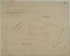
A survey of the Grange of Balscaddin in the Barony of Balrothery and County of Dublin belongg. to the Dean & Chapter of Christ Church by J.B. -[?]. March 7 1795
Map
Main Creator:
Brownrigg,
John
, ca. 1748-1838, surveyor
Language:
English
Format:
Map
In collection:
Longfield Map Collection
Published / Created
[March 07 1795]
Notes
Physical description: 1 map Geographic Coverage: Bar...
Call Number:
Loading...
Located:
Loading...
A map of the Grange of Balscaddin in the Barony of Balrothery & County of Dublin - the Estate of the Dean of Christ Church. Surveyed by J.L. 1823.
Map
Main Creator:
Longfield,
John
, ca. 1775-1833, surveyor
Language:
English
Format:
Map
In collection:
Longfield Map Collection
Published / Created
[1823]
Notes
Physical description: 1 map Geographic Coverage: Bar...
Call Number:
Loading...
Located:
Loading...
A map of the Lands of Ring in the Barony of Balrothery and County of Dublin, part of the Estate of Jenico Viscount Gormanston. Surveyed by John Longfield. 1819.
Map
Main Creator:
Longfield,
John
, ca. 1775-1833, surveyor
Language:
English
Format:
Map
In collection:
Longfield Map Collection
Published / Created
[1819]
Notes
Physical description: 1 map Geographic Coverage: Bar...
Call Number:
Loading...
Located:
Loading...
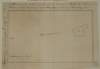
A survey of pt. of the Lands of Flemingstown in the Co of Dublin pt. of the Estate of the Marquis of Lansdown let to M. Dillon [Ths.] in April by John Longfield 1832.
Map
Main Creator:
Longfield,
John
, ca. 1775-1833, surveyor
Language:
English
Format:
Map
In collection:
Longfield Map Collection
Published / Created
[April 1832]
Notes
In poor condition with a tear across the top of the m...
Call Number:
Loading...
Located:
Loading...
A map of the Lands of Gracedien and its subdenominations in the Barony of Balrothery & County of Dublin, the Estate of John Venox Esq. by John Brownrigg. November 1794. Scale 20 Perches to an Inch
Map
Main Creator:
Brownrigg,
John
, ca. 1748-1838, surveyor
Language:
English
Format:
Map
In collection:
Longfield Map Collection
Published / Created
[November 1794]
Notes
Physical description: 1 map Geographic Coverage: Bar...
Call Number:
Loading...
Located:
Loading...
A map of part of the Lands of Lusk, in the County of Dublin the Estate of W. Parsons Esq. Surveyed by Laurence Magennis 1791. Copy.d. by J. Brownrigg 1792. Scale 20 Perches to an Inch.
Map
Main Creator:
Brownrigg,
John
, ca. 1748-1838, surveyor
Language:
English
Format:
Map
In collection:
Longfield Map Collection
Published / Created
[1792]
Notes
Physical description: 1 map Geographic Coverage: Bar...
Call Number:
Loading...
Located:
Loading...
A map of part of the Lands of Palmerstown in the County of Dublin let by the Revd Sir B. Synge Hutchinson Bt. to [illegible]. Surveyed by J.L. 1816
Map
Main Creator:
Longfield,
John
, ca. 1775-1833, surveyor
Language:
English
Format:
Map
In collection:
Longfield Map Collection
Published / Created
[1816]
Notes
Physical description: 1 map Geographic Coverage: Bar...
Call Number:
Loading...
Located:
Loading...
A survey of the Demense of Wyanstown, etc., etc., in the Barony of Balrothery, County of Dublin, done for M. McCausland Esq. by J.L.
Map
Main Creator:
Longfield,
John
, ca. 1775-1833, surveyor
Language:
English
Format:
Map
In collection:
Longfield Map Collection
Published / Created
[between 1795 and 1833]
Notes
Physical description: 1 map Geographic Coverage: Bar...
Call Number:
Loading...
Located:
Loading...
A survey of part of the Lands of Cottrellstown and Weystown partly in the Parish of Palmerstown and partly in the Parish of Ballymadun in the Barony of Balrothery & Co Dublin, belonging to the Vicars & prebends of Christ Church Dublin. Let to [illegible]. Surveyed by Brownrigg and Co. 1800
Map
Main Creator:
Brownrigg & Co., fl. 1801-1809, surveyors
Language:
English
Format:
Map
In collection:
Longfield Map Collection
Published / Created
[1800]
Notes
Physical description: 1 map Geographic Coverage: Par...
Contributors:
“
...Brownrigg,
John
, ca. 1748-1838, surveyor...
”
Call Number:
Loading...
Located:
Loading...
[A map of the townland of ] Turvey, by Scalé, Brownrigg & Sherrard, 1774. Scale 20 Perches to an Inch
Map
Main Creator:
Scalé, Brownrigg & Sherrard, fl. 1774-1778, surveyors
Language:
English
Format:
Map
In collection:
Longfield Map Collection
Published / Created
[1774]
Notes
Physical description: 1 map Geographic Coverage: Bar...
Contributors:
“
...Brownrigg,
John
, ca. 1748-1838, surveyor...
”
Call Number:
Loading...
Located:
Loading...
Get RSS Feed
Email this Search
History
Narrow Search
Digitised
Remove Filters
Clear Filter
Genre: Manuscript maps
Clear Filter
Region: Balrothery (Barony)
Clear Filter
Subject: Land tenure
Format
11
Map
Online Availability
11
Digitised
Published / Created
From:
To:
Subject
11
Administration of estates
11
Boundaries (Estates)
Land tenure
11
Land use surveys
5
History
Author
6
Longfield, John, ca. 1775-1833, surveyor
3
Brownrigg, John, ca. 1748-1838, surveyor
1
Brownrigg & Co., fl. 1801-1809, surveyors
1
Scalé, Brownrigg & Sherrard, fl. 1774-1778, surveyors
Collections
11
Longfield Map Collection
Language
11
English
Genre
Manuscript maps
11
Maps, Manuscript
5
Early works to 1800
Era
5
18th century
Region
Balrothery (Barony)
11
Dublin (County)
11
Dublin (Ireland : County)
11
Ireland
1
Ballymadun Parish
1
Ballymadun Parish (Ireland)
more ...
1
Palmerstown Parish
1
Palmerstown Parish (Ireland)
see all ...
less ...
Loading...
![A survey of the Grange of Balscaddin in the Barony of Balrothery and County of Dublin belongg. to the Dean & Chapter of Christ Church by J.B. -[?]. March 7 1795](/IIIF/000310000/000302261/vtls000302261_001.jp2/full/100,/0/default.jpg)


![A survey of pt. of the Lands of Flemingstown in the Co of Dublin pt. of the Estate of the Marquis of Lansdown let to M. Dillon [Ths.] in April by John Longfield 1832.](/IIIF/000310000/000302275/vtls000302275_001.jp2/full/100,/0/default.jpg)

![A map of part of the Lands of Palmerstown in the County of Dublin let by the Revd Sir B. Synge Hutchinson Bt. to [illegible]. Surveyed by J.L. 1816](/IIIF/000310000/000302272/vtls000302272_001.jp2/full/100,/0/default.jpg)

![A survey of part of the Lands of Cottrellstown and Weystown partly in the Parish of Palmerstown and partly in the Parish of Ballymadun in the Barony of Balrothery & Co Dublin, belonging to the Vicars & prebends of Christ Church Dublin. Let to [illegible]. Surveyed by Brownrigg and Co. 1800](/IIIF/000310000/000302264/vtls000302264_001.jp2/full/100,/0/default.jpg)
![[A map of the townland of ] Turvey, by Scalé, Brownrigg & Sherrard, 1774. Scale 20 Perches to an Inch](/IIIF/000310000/000302280/vtls000302280_001.jp2/full/100,/0/default.jpg)