Showing
1 - 20
results of
53
for search '
Will, John.
'
Skip to content
Toggle navigation
NLI Website
- Catalogue -
English
Gaeilge
Home
Help
Advanced Search
Browse
Orders
Ask a Librarian
Language
English
Gaeilge
All Fields
Title
Author
Subject
Call Number
ISBN/ISSN
Publisher
Coordinates
Search digitised content only
FIND
Author
Will, John.
Results
Showing
1 - 20
results of
53
for search '
Will, John.
'
, query time: 0.06s
List
Grid
Sort
Relevance
Newest First
Oldest First
Call Number
Author
Title
1
2
3
Next
3
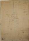
A map of Killishee [Killashee] Soordlestown [Swordlestown] etc, in the barony of Naas and County of Kildare belonging to Robert Graydon. By John Brownrigg 1777. Names of tenants shown on some holdings.
Map
Main Creator:
Brownrigg,
John
, ca. 1748-1838, surveyor
Language:
English
Format:
Map
In collection:
Longfield Map Collection
Published / Created
[1777]
Notes
Physical description: 1 map Geographic Coverage: Bar...
Call Number:
Loading...
Located:
Loading...
A map of part of Peafield in the Barony of Coolock & County of Dublin, the Estate of [illegible] Bever Esq. Survey'd by John Brownrigg 1795. Scale 20 Perches to an Inch
Map
Main Creator:
Brownrigg,
John
, ca. 1748-1838, surveyor
Language:
English
Format:
Map
In collection:
Longfield Map Collection
Published / Created
[1795]
Notes
Physical description: 1 map Geographic Coverage: Bar...
Call Number:
Loading...
Located:
Loading...
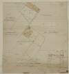
A map of Ballinealoe and Williamstown in the barony of Fore and County of Westmeath, the estate of Thomas Smyth. By J.B. March 1781.
Map
Main Creator:
Brownrigg,
John
, ca. 1748-1838, surveyor
Language:
English
Format:
Map
In collection:
Longfield Map Collection
Published / Created
[1781]
Notes
Inset map: "A map of several lots of ground lying bet...
Call Number:
Loading...
Located:
Loading...
A survey of the demense of Killdalkey [Kildalkey] in the parish of Killdalkey [Kildalkey] barony of Lune and County of Meath [Surveyed by J.B.] May 7th 1772 for Robert Walle.
Map
Main Creator:
Brownrigg,
John
, ca. 1748-1838, surveyor
Language:
English
Format:
Map
In collection:
Longfield Map Collection
Published / Created
[May 07 1772]
Notes
Physical description: 1 map Geographic Coverage: Par...
Call Number:
Loading...
Located:
Loading...
A survey of Cloonihane alias Dovegrove in the barony of Eglish and Kings [Offaly] County the estate of the Rt. Hon. Charles Earl of Drogheda. By J. Brownrigg. 1789.
Map
Main Creator:
Brownrigg,
John
, ca. 1748-1838, surveyor
Language:
English
Format:
Map
In collection:
Longfield Map Collection
Published / Created
[1789]
Notes
Physical description: 1 map Geographic Coverage: Bar...
Call Number:
Loading...
Located:
Loading...
A map of the Lands of Gracedien and its subdenominations in the Barony of Balrothery & County of Dublin, the Estate of John Venox Esq. by John Brownrigg. November 1794. Scale 20 Perches to an Inch
Map
Main Creator:
Brownrigg,
John
, ca. 1748-1838, surveyor
Language:
English
Format:
Map
In collection:
Longfield Map Collection
Published / Created
[November 1794]
Notes
Physical description: 1 map Geographic Coverage: Bar...
Call Number:
Loading...
Located:
Loading...
A map of Ballymore in the barony of Granard and County of Longford the joint estate of the Honable. George F. Lyttleton and William F. Greville by John Brownrigg 1792. Scale 20 perches to an inch. Table of reference showing denominations & acreage.
Map
Main Creator:
Brownrigg,
John
, ca. 1748-1838, surveyor
Language:
English
Format:
Map
In collection:
Longfield Map Collection
Published / Created
[1792]
Notes
Some staining on the right-hand side and bottom of th...
Call Number:
Loading...
Located:
Loading...
A map of the Line intended for the Royal Canal from Ashtown to Barberstown in the County of Dublin, as laid out by Richd. Evans Enginr. Surveyed by J. Brownrigg. 1791. Scale 500 Feet to an Inch
Map
Main Creator:
Brownrigg,
John
, ca. 1748-1838, surveyor
Language:
English
Format:
Map
In collection:
Longfield Map Collection
Published / Created
[1791]
Notes
Physical description: 1 map Geographic Coverage: Bar...
Call Number:
Loading...
Located:
Loading...
A map of Bay View & Mount Pleasant in the Barony of Coolock & County of Dublin belonging to Robt. Burton Esq. Surveyed by J. Brownrigg 1792. Scale 10 Perches to an Inch
Map
Main Creator:
Brownrigg,
John
, ca. 1748-1838, surveyor
Language:
English
Format:
Map
In collection:
Longfield Map Collection
Published / Created
[1792]
Notes
Physical description: 1 map Geographic Coverage: Bar...
Call Number:
Loading...
Located:
Loading...
A survey of Mylarstown [Mylerstown] in the Islands of Allen barony of Great Connell County of Kildare the estate of Thomas Hutchinson Smyth. By John Brownrigg 1794. Scale 20 perches to an inch. Table of reference, numbered allotments & descriptive details of land with acreage of land tenants names shown.
Map
Main Creator:
Brownrigg,
John
, ca. 1748-1838, surveyor
Language:
English
Format:
Map
In collection:
Longfield Map Collection
Published / Created
[1794]
Notes
Physical description: 1 map Geographic Coverage: Bar...
Call Number:
Loading...
Located:
Loading...
A survey of a piece of ground called the Slip field near Clontarf in the Barony of Coolock and County of Dublin let by A. Savage Esq. To John Ash by J.B. 1792. Scale 10 Perches to an Inch
Map
Main Creator:
Brownrigg,
John
, ca. 1748-1838, surveyor
Language:
English
Format:
Map
In collection:
Longfield Map Collection
Published / Created
[1792]
Notes
Physical description: 1 map Geographic Coverage: Bar...
Call Number:
Loading...
Located:
Loading...
A survey of the lands of Knavenstown [Knavinstown] the two Killawrences & Ballylogas in the barony of western Ophaly and County of Kildare the estate of the Dean and Chapter of Kildare let to Charles Fitzgerald. By J. Brownrigg, 1788. Scale 20 perches to an inch.
Map
Main Creator:
Brownrigg,
John
, ca. 1748-1838, surveyor
Language:
English
Format:
Map
In collection:
Longfield Map Collection
Published / Created
[1788]
Notes
Physical description: 1 map Geographic Coverage: Bar...
Call Number:
Loading...
Located:
Loading...
A survey of part of the Lands of Puckstown in the County of Dublin, let by Thos. Twig Esq. to [illegible] Hammell Esq. Surveyed by J.B. 18th May 1793. Scale 10 Perches to an Inch
Map
Main Creator:
Brownrigg,
John
, ca. 1748-1838, surveyor
Language:
English
Format:
Map
In collection:
Longfield Map Collection
Published / Created
[May 18 1793]
Notes
Physical description: 1 map Geographic Coverage: Bar...
Call Number:
Loading...
Located:
Loading...
A survey of Carn in the barony of Fore and County of Westmeath part of the estate of the Rt. Hon. the Earl of Longford. By J.B. December 1798. Scale 20 perches to an inch.
Map
Main Creator:
Brownrigg,
John
, ca. 1748-1838, surveyor
Language:
English
Format:
Map
In collection:
Longfield Map Collection
Published / Created
[December 1798]
Notes
Physical description: 1 map Geographic Coverage: Bar...
Call Number:
Loading...
Located:
Loading...
A survey of Aughakyne [Aghakine] in the parish of Saint Cullom Kill, barony of Granard and County of Longford the estate of Thomas Burrows by John Brownrigg August 27, 1790. A scale of twenty perches to an inch. Table of reference, names of tenants & acreage shown.
Map
Main Creator:
Brownrigg,
John
, ca. 1748-1838, surveyor
Language:
English
Format:
Map
In collection:
Longfield Map Collection
Published / Created
[August 27 1790]
Notes
Physical description: 1 map Geographic Coverage: Par...
Call Number:
Loading...
Located:
Loading...
A map of a proposed line to be laid out as an equal give and take straight boundary between Hodgestown the estate of the Rt. Hon. the Earl of Longford, and Higginstown the estate of George Nugent. Surveyed by John Brownrigg. 1796. Scale 20 perches to an inch.
Map
Main Creator:
Brownrigg,
John
, ca. 1748-1838, surveyor
Language:
English
Format:
Map
In collection:
Longfield Map Collection
Published / Created
[1796]
Notes
Physical description: 1 map Geographic Coverage: Bar...
Call Number:
Loading...
Located:
Loading...
A survey of part of Corballis in the barony [of Kilkea and Moone] and County of Kildare belonging to Thomas Graydon. By J. Brownrigg 1779. Names of tenants & area of holdings shown.
Map
Main Creator:
Brownrigg,
John
, ca. 1748-1838, surveyor
Language:
English
Format:
Map
In collection:
Longfield Map Collection
Published / Created
[1779]
Notes
Physical description: 1 map Geographic Coverage: Bar...
Call Number:
Loading...
Located:
Loading...
A map of Fyagh [Feagh] in the barony of Kells Lower and County of Meath, the estate of Thomas Bligh. Surveyed in September 1787 by J.B.
Map
Main Creator:
Brownrigg,
John
, ca. 1748-1838, surveyor
Language:
English
Format:
Map
In collection:
Longfield Map Collection
Published / Created
[1787-1788]
Notes
Inset map: "A map of a piece of ground on the west si...
Call Number:
Loading...
Located:
Loading...
A map of Mylarstown [Mylerstown] & Killiagh [Killeagh] in the Island of Allen and County of Kildare the estate of Thomas Smyth held by William Wyly, Joseph & Aaron Mickle. Surveyed February 1765 by John Nettervile. Scale 40 perches to an inch. Table of reference showing tenants & acreage of holdings.
Map
Main Creator:
Netterville,
John
, fl. 1747-1768, surveyor
Language:
English
Format:
Map
In collection:
Longfield Map Collection
Published / Created
[February 1765]
Notes
Physical description: 1 map Geographic Coverage: Bar...
Call Number:
Loading...
Located:
Loading...
Map of the Demense of Kinturk in the barony of Fore and County of Westmeath the seat of William Pollard. Surveyed in 1786 by J.B. Scale 10 perches to an inch.
Map
Main Creator:
Brownrigg,
John
, ca. 1748-1838, surveyor
Language:
English
Format:
Map
In collection:
Longfield Map Collection
Published / Created
[1786]
Notes
Physical description: 1 map Geographic Coverage: Bar...
Call Number:
Loading...
Located:
Loading...
1
2
3
Next
3
Get RSS Feed
Email this Search
History
Narrow Search
Clear Filter
Digitised
Remove Filters
Clear Filter
Era: 18th century
Clear Filter
Genre: Maps, Manuscript
Format
53
Map
Online Availability
Digitised
Published / Created
From:
To:
Subject
53
Administration of estates
53
Boundaries (Estates)
53
History
53
Land tenure
53
Land use surveys
Author
44
Brownrigg, John, ca. 1748-1838, surveyor
4
Scalé, Brownrigg & Sherrard, fl. 1774-1778, surveyors
1
Bell, John (I and II), fl. 1721-1820
1
Browne, John, fl. 1788-ca. 1807, surveyor
1
Brownrigg & Co., fl. 1801-1809, surveyors
1
Netterville, John, fl. 1747-1768, surveyor
more ...
1
O'Brien, John, fl. 1784-1820, surveyor
see all ...
less ...
Collections
53
Longfield Map Collection
Language
53
English
Genre
53
Early works to 1800
53
Manuscript maps
Maps, Manuscript
Era
18th century
Region
53
Ireland
19
Dublin (Ireland : County)
18
Dublin (County)
9
Coolock (Barony)
9
Meath
9
Meath (Ireland)
more ...
8
Westmeath
8
Westmeath (Ireland)
7
Kildare (County)
7
Kildare (Ireland : County)
5
Balrothery (Barony)
5
Fore (Barony)
5
Longford (County)
5
Longford (Ireland : County)
4
Granard (Barony)
4
Skreen (Barony)
3
Connell (Barony)
2
Columbkille Parish
2
Columbkille Parish (Ireland)
2
Dublin (Barony)
2
Dublin (Ireland)
2
Dublin City (Barony)
2
Farbill (Barony)
2
Limerick (County)
2
Limerick (Ireland : County)
2
Offaly
2
Offaly (Ireland)
2
Offaly West (Barony)
2
Rathdown (Barony)
1
Ballymadun Parish
see all ...
less ...
Loading...
![A map of Killishee [Killashee] Soordlestown [Swordlestown] etc, in the barony of Naas and County of Kildare belonging to Robert Graydon. By John Brownrigg 1777. Names of tenants shown on some holdings.](/IIIF/000310000/000302012/vtls000302012_001.jp2/full/100,/0/default.jpg)
![A map of part of Peafield in the Barony of Coolock & County of Dublin, the Estate of [illegible] Bever Esq. Survey'd by John Brownrigg 1795. Scale 20 Perches to an Inch](/IIIF/000310000/000301182/vtls000301182_001.jp2/full/100,/0/default.jpg)
![A survey of the demense of Killdalkey [Kildalkey] in the parish of Killdalkey [Kildalkey] barony of Lune and County of Meath [Surveyed by J.B.] May 7th 1772 for Robert Walle.](/IIIF/000310000/000301788/vtls000301788_001.jp2/full/100,/0/default.jpg)
![A survey of Cloonihane alias Dovegrove in the barony of Eglish and Kings [Offaly] County the estate of the Rt. Hon. Charles Earl of Drogheda. By J. Brownrigg. 1789.](/IIIF/000310000/000302163/vtls000302163_001.jp2/full/100,/0/default.jpg)


![A survey of Mylarstown [Mylerstown] in the Islands of Allen barony of Great Connell County of Kildare the estate of Thomas Hutchinson Smyth. By John Brownrigg 1794. Scale 20 perches to an inch. Table of reference, numbered allotments & descriptive details of land with acreage of land tenants names shown.](/IIIF/000310000/000301989/vtls000301989_001.jp2/full/100,/0/default.jpg)

![A survey of the lands of Knavenstown [Knavinstown] the two Killawrences & Ballylogas in the barony of western Ophaly and County of Kildare the estate of the Dean and Chapter of Kildare let to Charles Fitzgerald. By J. Brownrigg, 1788. Scale 20 perches to an inch.](/IIIF/000310000/000302091/vtls000302091_001.jp2/full/100,/0/default.jpg)
![A survey of part of the Lands of Puckstown in the County of Dublin, let by Thos. Twig Esq. to [illegible] Hammell Esq. Surveyed by J.B. 18th May 1793. Scale 10 Perches to an Inch](/IIIF/000310000/000301180/vtls000301180_001.jp2/full/100,/0/default.jpg)

![A survey of Aughakyne [Aghakine] in the parish of Saint Cullom Kill, barony of Granard and County of Longford the estate of Thomas Burrows by John Brownrigg August 27, 1790. A scale of twenty perches to an inch. Table of reference, names of tenants & acreage shown.](/IIIF/000310000/000302252/vtls000302252_001.jp2/full/100,/0/default.jpg)

![A survey of part of Corballis in the barony [of Kilkea and Moone] and County of Kildare belonging to Thomas Graydon. By J. Brownrigg 1779. Names of tenants & area of holdings shown.](/IIIF/000310000/000302010/vtls000302010_001.jp2/full/100,/0/default.jpg)
![A map of Fyagh [Feagh] in the barony of Kells Lower and County of Meath, the estate of Thomas Bligh. Surveyed in September 1787 by J.B.](/IIIF/000310000/000301785/vtls000301785_001.jp2/full/100,/0/default.jpg)
![A map of Mylarstown [Mylerstown] & Killiagh [Killeagh] in the Island of Allen and County of Kildare the estate of Thomas Smyth held by William Wyly, Joseph & Aaron Mickle. Surveyed February 1765 by John Nettervile. Scale 40 perches to an inch. Table of reference showing tenants & acreage of holdings.](/IIIF/000310000/000302034/vtls000302034_001.jp2/full/100,/0/default.jpg)
