Showing
1 - 20
results of
174
for search '
Brownrigg, John, ca. 1748-1838, surveyor
'
Skip to content
Toggle navigation
NLI Website
- Catalogue -
English
Gaeilge
Home
Help
Advanced Search
Browse
Orders
Ask a Librarian
Language
English
Gaeilge
All Fields
Title
Author
Subject
Call Number
ISBN/ISSN
Publisher
Coordinates
Search digitised content only
FIND
Author
Brownrigg, John, ca. 1748-1838, surveyor
Results
Showing
1 - 20
results of
174
for search '
Brownrigg, John, ca. 1748-1838, surveyor
'
, query time: 0.10s
List
Grid
Sort
Relevance
Newest First
Oldest First
Call Number
Author
Title
1
2
3
4
5
6
7
8
9
Next
9
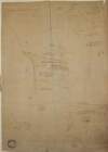
A survey of Mylerstown in the Islans of Allen barony of Great Connell and County of Kildare the estate of Thomas Hutchinson Smyth By John Brown[r]igg. 1792. Scale 20 perches to an inch. Names of adjoining tenants shown
Map
Main Creator:
Brownrigg
,
John
,
ca
.
1748
-
1838
,
surveyor
Language:
English
Format:
Map
In collection:
Longfield Map Collection
Published / Created
[1792]
Notes
Physical description: 1 map Geographic Coverage: Bar...
Call Number:
Loading...
Located:
Loading...
A survey of part of the estate of the Rt. Hon. Lord Templetown. By John Brownrigg 1800, at Drumaoib ... and Liseenan in County Monaghan. Names of tenants & acreage of holdings shown.
Map
Main Creator:
Brownrigg
,
John
,
ca
.
1748
-
1838
,
surveyor
Language:
English
Format:
Map
In collection:
Longfield Map Collection
Published / Created
[1800]
Notes
Physical description: 1 map Geographic Coverage: Bar...
Call Number:
Loading...
Located:
Loading...
A map of Ballinealoe and Williamstown in the barony of Fore and County of Westmeath, the estate of Thomas Smyth. By J.B. March 1781.
Map
Main Creator:
Brownrigg
,
John
,
ca
.
1748
-
1838
,
surveyor
Language:
English
Format:
Map
In collection:
Longfield Map Collection
Published / Created
[1781]
Notes
Inset map: "A map of several lots of ground lying bet...
Call Number:
Loading...
Located:
Loading...
A map of a lot of ground lying on the north side of Merrion Row formerly belonging to Susanna Landie, deceased. Surveyed by J. Brownrigg July 6, 1791. Adjoining tenants shown & notes on the concerns
Map
Main Creator:
Brownrigg
,
John
,
ca
.
1748
-
1838
,
surveyor
Language:
English
Format:
Map
In collection:
Longfield Map Collection
Published / Created
[July 06 1791]
Notes
Physical description: 1 map Geographic Coverage: Dub...
Call Number:
Loading...
Located:
Loading...
A map of a concern on Constitution Hill in the County of the City of Dublin. Surveyed for Mr. John Wilkinson by John Brownrigg 2nd Dec 1791. Scale 20 feet to an inch
Map
Main Creator:
Brownrigg
,
John
,
ca
.
1748
-
1838
,
surveyor
Language:
English
Format:
Map
In collection:
Longfield Map Collection
Published / Created
[December 02 1791]
Notes
Physical description: 1 map Geographic Coverage: Dub...
Call Number:
Loading...
Located:
Loading...
A map of part of the Farm of St. Sepulchres in the County of Dublin held under his Grace Robt. Lord Archbishop of Dublin by Wm. Thomas Esq. Survey'd by John Brownrigg 1795. Scale 80 Feet to an Inch
Map
Main Creator:
Brownrigg
,
John
,
ca
.
1748
-
1838
,
surveyor
Language:
English
Format:
Map
In collection:
Longfield Map Collection
Published / Created
[1795]
Notes
Physical description: 1 map Geographic Coverage: Bar...
Call Number:
Loading...
Located:
Loading...
A map of a parcel of ground in St. Sepulchres in the County of Dublin let by John Hatch to Robert Watson Wade and Edward Whitton. Surveyed by John Brownrigg. June-Aug 1791. Scale 100 feet to an inch.
Map
Main Creator:
Brownrigg
,
John
,
ca
.
1748
-
1838
,
surveyor
Language:
English
Format:
Map
In collection:
Longfield Map Collection
Published / Created
[June 1791]
Notes
In mylar covering. Physical description: 1 map Geogr...
Call Number:
Loading...
Located:
Loading...
A rough map and section of part of the mill race and river adjoining Elm [?] in the County of Limerick done for the Honble. Lieut. General Massy? By John Brownrigg October 1787. Scale of perches.
Map
Main Creator:
Brownrigg
,
John
,
ca
.
1748
-
1838
,
surveyor
Language:
English
Format:
Map
In collection:
Longfield Map Collection
Published / Created
[October 1787]
Notes
Physical description: 1 map Geographic Coverage: Bar...
Call Number:
Loading...
Located:
Loading...
A survey of part of the farm of St. Sepulchre's in the County of Dublin let by His Grace Robert Lord Archbishop of Dublin to Mr. Francis Usher. By John Brownrigg 1782. Scale 400 feet to an inch
Map
Main Creator:
Brownrigg
,
John
,
ca
.
1748
-
1838
,
surveyor
Language:
English
Format:
Map
In collection:
Longfield Map Collection
Published / Created
[1782]
Notes
Physical description: 1 map Geographic Coverage: Dub...
Call Number:
Loading...
Located:
Loading...
A survey of two fields on Rathmines Road part of the Estate of the Right Honble. the Earl of Meath, by John Brownrigg. Oct. 1791
Map
Main Creator:
Brownrigg
,
John
,
ca
.
1748
-
1838
,
surveyor
Language:
English
Format:
Map
In collection:
Longfield Map Collection
Published / Created
[October 1791]
Notes
Physical description: 1 map Geographic Coverage: Bar...
Call Number:
Loading...
Located:
Loading...
A map of a lot of ground between Boyne Street and Denzile Street the property of Thomas Hamilton. By John Brownrigg Nov 19th 1791.
Map
Main Creator:
Brownrigg
,
John
,
ca
.
1748
-
1838
,
surveyor
Language:
English
Format:
Map
In collection:
Longfield Map Collection
Published / Created
[November 19 1791]
Notes
Physical description: 1 map Geographic Coverage: Dub...
Call Number:
Loading...
Located:
Loading...
A map of that part of the Royal Canal intended to pass through the County of Dublin from Summer Hill to Ashtown. By John Brownrigg 1790. Scale 500 feet to an Inch. Table of reference showing denominations Proprietors Leases under-Tenants & remarks on the properties
Map
Main Creator:
Brownrigg
,
John
,
ca
.
1748
-
1838
,
surveyor
Language:
English
Format:
Map
In collection:
Longfield Map Collection
Published / Created
[1790]
Notes
Physical description: 1 map Geographic Coverage: Dub...
Call Number:
Loading...
Located:
Loading...
A map of Ballymore in the barony of Granard and County of Longford the joint estate of the Honable. George F. Lyttleton and William F. Greville by John Brownrigg 1792. Scale 20 perches to an inch. Table of reference showing denominations & acreage.
Map
Main Creator:
Brownrigg
,
John
,
ca
.
1748
-
1838
,
surveyor
Language:
English
Format:
Map
In collection:
Longfield Map Collection
Published / Created
[1792]
Notes
Some staining on the right-hand side and bottom of th...
Call Number:
Loading...
Located:
Loading...
A map of the Line intended for the Royal Canal from Ashtown to Barberstown in the County of Dublin, as laid out by Richd. Evans Enginr. Surveyed by J. Brownrigg. 1791. Scale 500 Feet to an Inch
Map
Main Creator:
Brownrigg
,
John
,
ca
.
1748
-
1838
,
surveyor
Language:
English
Format:
Map
In collection:
Longfield Map Collection
Published / Created
[1791]
Notes
Physical description: 1 map Geographic Coverage: Bar...
Call Number:
Loading...
Located:
Loading...
A map of two Holdings in the street of Tallaght in the County of Dublin belonging to Mr. Anthy. Cleval by J. Brownrigg 1797. Scale Eight Perches to an Inch
Map
Main Creator:
Brownrigg
,
John
,
ca
.
1748
-
1838
,
surveyor
Language:
English
Format:
Map
In collection:
Longfield Map Collection
Published / Created
[1797]
Notes
Physical description: 1 map Geographic Coverage: Bar...
Call Number:
Loading...
Located:
Loading...
A map of a holding on the north side of Summer Hill in the City of Dublin the propety of Mr. Wood. Surveyed by J.B. 1792. Names of adjoining tenants shown
Map
Main Creator:
Brownrigg
,
John
,
ca
.
1748
-
1838
,
surveyor
Language:
English
Format:
Map
In collection:
Longfield Map Collection
Published / Created
[1792]
Notes
Physical description: 1 map Geographic Coverage: Dub...
Call Number:
Loading...
Located:
Loading...
A survey of the Lands of Furry Hill, a subdenomination of Balally in the County of Dublin done in 1777 by John Connor and copied 1782 by John Brownrigg. Scale 10 Perches to an Inch
Map
Main Creator:
Brownrigg
,
John
,
ca
.
1748
-
1838
,
surveyor
Language:
English
Format:
Map
In collection:
Longfield Map Collection
Published / Created
[1782]
Notes
Physical description: 1 map Geographic Coverage: Bar...
Call Number:
Loading...
Located:
Loading...
A survey of part of the lands of Clondoogan, Clonmahon, and [Drumlargan in the barony of Deece Upper] in the barony of Moyfenrath and County of Meath the estate of the Rt. Hon. Lord Langford. By John Brownrigg 1795. Names of tenants and acreage of holdings shown. Scale 20 perches to an inch.
Map
Main Creator:
Brownrigg
,
John
,
ca
.
1748
-
1838
,
surveyor
Language:
English
Format:
Map
In collection:
Longfield Map Collection
Published / Created
[1795]
Notes
Physical description: 1 map Geographic Coverage: Bar...
Call Number:
Loading...
Located:
Loading...
A map of the mill and part of the lands of Ardmulchon [Ardmulchan] intended to be taken for the use of the Boyne Navigation the estate of Lord Boyne. John Martin tenant. Surveyed by John Brownrigg 1791. Scale 250 feet to an inch. A note showing that the land purchased by the company was 1a. 1r. and not 2r. 20p.
Map
Main Creator:
Brownrigg
,
John
,
ca
.
1748
-
1838
,
surveyor
Language:
English
Format:
Map
In collection:
Longfield Map Collection
Published / Created
[1791]
Notes
Physical description: 1 map Geographic Coverage: Bar...
Call Number:
Loading...
Located:
Loading...
A survey of part of Corballis in the barony [of Kilkea and Moone] and County of Kildare belonging to Thomas Graydon. By J. Brownrigg 1779. Names of tenants & area of holdings shown.
Map
Main Creator:
Brownrigg
,
John
,
ca
.
1748
-
1838
,
surveyor
Language:
English
Format:
Map
In collection:
Longfield Map Collection
Published / Created
[1779]
Notes
Physical description: 1 map Geographic Coverage: Bar...
Call Number:
Loading...
Located:
Loading...
1
2
3
4
5
6
7
8
9
Next
9
Get RSS Feed
Email this Search
History
Narrow Search
Digitised
Remove Filters
Clear Filter
Region: Ireland
Format
171
Map
2
Prints & Drawings
1
Manuscript
Online Availability
104
Not Digitised
70
Digitised
Published / Created
From:
To:
Subject
171
Land use surveys
169
Administration of estates
169
Boundaries (Estates)
169
Land tenure
117
History
2
Administration of Estates
more ...
2
Antiquities
2
Cartography
2
Dolmens
2
Estates
2
Irish
2
Maps
2
Maps and Surveys
2
Surveyors
1
Estate papers
1
Maps, Manuscript
see all ...
less ...
Author
114
Brownrigg, John, ca. 1748-1838, surveyor
42
Brownrigg & Co., fl. 1801-1809, surveyors
6
Brownrigg, Longfield and Murray, fl. 1799-ca. 1805, surveyors
4
Scalé, Brownrigg & Sherrard, fl. 1774-1778, surveyors
3
Longfield, John, ca. 1775-1833, surveyor
2
Brownrigg & Sherrard, fl. 1777-1778, surveyors
more ...
2
Frazer, William, d. 1905, artist
1
Longfield, William, fl. 1825-ca. 1870, surveyor
see all ...
less ...
Collections
170
Longfield Map Collection
2
Sketch books of Irish antiquities
1
Fowler and Rawdon of Rathmoylon Papers, 1710-1897.
1
Gardiner Papers, ca. 1667-1898.
Language
174
English
Genre
170
Manuscript maps
169
Maps, Manuscript
116
Early works to 1800
2
Ink drawings
2
Pen works
2
Wash drawings
Era
117
18th century
2
1880-1900
1
1780-1840
Region
Ireland
125
Dublin (Ireland : County)
124
Dublin (County)
60
Dublin (Ireland)
58
Dublin
20
Rathdown (Barony)
more ...
14
Coolock (Barony)
14
Meath (Ireland)
13
Dublin (Barony)
13
Meath
12
Dublin City (Barony)
12
Uppercross (Barony)
8
Kildare (County)
8
Kildare (Ireland : County)
8
Westmeath
8
Westmeath (Ireland)
7
Longford (Ireland : County)
5
Balrothery (Barony)
5
Fore (Barony)
5
Longford (County)
4
Nethercross (Barony)
4
Newcastle (Barony)
3
Granard (Barony)
3
Skreen (Barony)
2
Castleknock (Barony)
2
Connell (Barony)
2
Farbill (Barony)
2
Kells Upper (Barony)
2
Laois
2
Laois (Ireland)
see all ...
less ...
Loading...
![A survey of Mylerstown in the Islans of Allen barony of Great Connell and County of Kildare the estate of Thomas Hutchinson Smyth By John Brown[r]igg. 1792. Scale 20 perches to an inch. Names of adjoining tenants shown](/IIIF/000310000/000301988/vtls000301988_001.jp2/full/100,/0/default.jpg)

![A rough map and section of part of the mill race and river adjoining Elm [?] in the County of Limerick done for the Honble. Lieut. General Massy? By John Brownrigg October 1787. Scale of perches.](/IIIF/000310000/000302246/vtls000302246_001.jp2/full/100,/0/default.jpg)

![A survey of part of the lands of Clondoogan, Clonmahon, and [Drumlargan in the barony of Deece Upper] in the barony of Moyfenrath and County of Meath the estate of the Rt. Hon. Lord Langford. By John Brownrigg 1795. Names of tenants and acreage of holdings shown. Scale 20 perches to an inch.](/IIIF/000310000/000301813/vtls000301813_001.jp2/full/100,/0/default.jpg)
![A map of the mill and part of the lands of Ardmulchon [Ardmulchan] intended to be taken for the use of the Boyne Navigation the estate of Lord Boyne. John Martin tenant. Surveyed by John Brownrigg 1791. Scale 250 feet to an inch. A note showing that the land purchased by the company was 1a. 1r. and not 2r. 20p.](/IIIF/000310000/000301863/vtls000301863_001.jp2/full/100,/0/default.jpg)
![A survey of part of Corballis in the barony [of Kilkea and Moone] and County of Kildare belonging to Thomas Graydon. By J. Brownrigg 1779. Names of tenants & area of holdings shown.](/IIIF/000310000/000302010/vtls000302010_001.jp2/full/100,/0/default.jpg)