![The ground plott of Bellfast [sic] with the cittadell [sic] designed upon the Strand /](/IIIF/000280000/000278082/vtls000278082_001.jp2/full/800,/0/default.jpg)
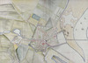
The ground plott of Bellfast [sic] with the cittadell [sic] designed upon the Strand /
Tho: Phillips,
[1685].
| Main Creator: | |
|---|---|
| Contributors: | |
| Summary: | Map of Belfast City showing fortifications, and Belfast Lough, Northern Ireland. Thomas Phillips submitted his survey recommendations to George Legge, 1st Lord Dartmouth, former Governor of Portsmouth, and Master General of the Ordnance. Lord Dartmouth had proposed that Commissioners be sent from England to Ireland to survey the stores and forts with a view to securing the Kingdom of Ireland against attack or invasion. Thomas Phillips' Irish survey was submitted by Lord Dartmouth to the Lord Lieutenant of Ireland, James Butler, 1st Duke of Ormond. The Lord Lieutenant submitted the survey to the Privy Council in 1685, but the proposals were not implemented. |
| Format: | Map |
| Language: | English |
| Citation: | National Library of Ireland. Department of Manuscripts. |
| Subjects: | |
| Notes: | Exhibits signs of 'pricking', a means by which exact originals would have been produced from this map. Physical description: 1 sheet : 29 x 40 inches. Geographic Coverage: Belfast, Northern Ireland. more |
As a digital copy of this item is available, the original will not be issued.
| Call Number | View In | Collection |
|---|---|---|
|
MS 3137 /41 |
Manuscripts Reading Room |
Manuscripts |