Showing
1 - 20
results of
343
for search '
Longfield, John, ca. 1775-1833, surveyor
'
Skip to content
Toggle navigation
NLI Website
- Catalogue -
English
Gaeilge
Home
Help
Advanced Search
Browse
Orders
Ask a Librarian
Language
English
Gaeilge
All Fields
Title
Author
Subject
Call Number
ISBN/ISSN
Publisher
Coordinates
Search digitised content only
FIND
Author
Longfield, John, ca. 1775-1833, surveyor
Results
Showing
1 - 20
results of
343
for search '
Longfield, John, ca. 1775-1833, surveyor
'
, query time: 0.04s
List
Grid
Sort
Relevance
Newest First
Oldest First
Call Number
Author
Title
1
2
3
4
5
6
7
8
9
10
11
Next
18
A map of part of the Lands of Rathcoole in the County of Dublin belonging to Laurence Clynch Esq. Surveyed and traced by John Longfield 1827. Scale 10 Perches to an Inch.
Map
Main Creator:
Longfield
,
John
,
ca
.
1775
-
1833
,
surveyor
Language:
English
Format:
Map
In collection:
Longfield Map Collection
Published / Created
[1827]
Notes
Physical description: 1 map Geographic Coverage: Bar...
Call Number:
Loading...
Located:
Loading...
A survey of Redesdale [Part of the Lands of Kilmacud] in the Parish of Stillorgan, Barony of Rathdown & County of Dublin for Walter Bourne Esq. June 1833 by Jn. Longfield. Scale 10 statute Perches to an Inch
Map
Main Creator:
Longfield
,
John
,
ca
.
1775
-
1833
,
surveyor
Language:
English
Format:
Map
In collection:
Longfield Map Collection
Published / Created
[June 1833]
Notes
Physical description: 1 map Geographic Coverage: Par...
Call Number:
Loading...
Located:
Loading...
A map of a holding in Blessington St in the City of Dublin let to Charles Hunt. Surveyed by J. Longfield 1824. Scale 20 feet to an Inch
Map
Main Creator:
Longfield
,
John
,
ca
.
1775
-
1833
,
surveyor
Language:
English
Format:
Map
In collection:
Longfield Map Collection
Published / Created
[1824]
Notes
Physical description: 1 map Geographic Coverage: Dub...
Call Number:
Loading...
Located:
Loading...
A map of part of the Lands of Dunleary in the Barony of Rathdown and County of Dublin let by Edwd. Bonham Esq. to Mrs. Maria Burbury Isaac. Survey'd by J.L. 1809. Scale 10 Perches to an Inch
Map
Main Creator:
Longfield
,
John
,
ca
.
1775
-
1833
,
surveyor
Language:
English
Format:
Map
In collection:
Longfield Map Collection
Published / Created
[1809]
Notes
Physical description: 1 map Geographic Coverage: Bar...
Call Number:
Loading...
Located:
Loading...
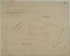
A map of Retreat [Raheen] upper half barony of Philipstown and Kings [Offaly] County belonging to Mr. Vicars. Surveyed by J. Longfield 1820. Scale 20 perches to an inch.
Map
Main Creator:
Longfield
,
John
,
ca
.
1775
-
1833
,
surveyor
Language:
English
Format:
Map
In collection:
Longfield Map Collection
Published / Created
[1820]
Notes
Physical description: 1 map Geographic Coverage: Bar...
Call Number:
Loading...
Located:
Loading...
A map of a piece of ground situate on the west side of New Bride St and in the County of the City of Dublin the property of John Synge. Surveyed 23 April 1828. By John Longfield. Scale 40 feet to an inch. Widow Briens holding shown
Map
Main Creator:
Longfield
,
John
,
ca
.
1775
-
1833
,
surveyor
Language:
English
Format:
Map
In collection:
Longfield Map Collection
Published / Created
[April 23 1828]
Notes
Physical description: 1 map Geographic Coverage: Dub...
Call Number:
Loading...
Located:
Loading...
A map of part of Lloyd's Rope walk and sundry other premises lying on the north side of Lower Abbey St. Taken from Saml. Byron's survey made in 1791 on which is described the ground purchased by the Commissrs. of Wide Streets as by Deed dated 2nd & 4th of Dec 1797 may appear; & also the ground which they now claim in addition to said Purchase done by John Longfield 1807. Scale 30 Feet to an Inch
Map
Main Creator:
Longfield
,
John
,
ca
.
1775
-
1833
,
surveyor
Language:
English
Format:
Map
In collection:
Longfield Map Collection
Published / Created
[1807]
Notes
Physical description: 1 map Geographic Coverage: Dub...
Call Number:
Loading...
Located:
Loading...
A map of part of the lands of Kelshamore in the barony of Talbotstown Upper and County of Wicklow the estate of the Rev. Sir Samuel Synge Hutchinson, Bart let to Edward Flynn, Junior. Surveyed by John Longfield 1813. Scale 20 perches to an inch.
Map
Main Creator:
Longfield
,
John
,
ca
.
1775
-
1833
,
surveyor
Language:
English
Format:
Map
In collection:
Longfield Map Collection
Published / Created
[1813]
Notes
Physical description: 1 map Geographic Coverage: Bar...
Call Number:
Loading...
Located:
Loading...
A survey of part of the lands of Moyvannan in the barony of Athlone and County of Roscommon the estate of Col. F. W. French M.P. Surveyed by J.L. 1825. Scale 16 perches to an inch. Owen Ward's allotment shown.
Map
Main Creator:
Longfield
,
John
,
ca
.
1775
-
1833
,
surveyor
Language:
English
Format:
Map
In collection:
Longfield Map Collection
Published / Created
[1825]
Notes
Physical description: 1 map Geographic Coverage: Bar...
Call Number:
Loading...
Located:
Loading...
A survey of part of Carah [Carragh] and part of Raheen in the barony of Clane and County Kildare part of the estate of John Mansfield. By J.L. 1813. Table of reference showing tenants names acreage of holdings
Map
Main Creator:
Longfield
,
John
,
ca
.
1775
-
1833
,
surveyor
Language:
English
Format:
Map
In collection:
Longfield Map Collection
Published / Created
[1813]
Notes
Some staining at the top of the map. Physical descrip...
Call Number:
Loading...
Located:
Loading...
A map of a piece of ground situate on the north side of Henry St in the City of Dublin, the property of Capt. Daniel. Surveyed by J.L. 1809. Also a description of a plot of ground on s.side of Malville Lane...
Map
Main Creator:
Longfield
,
John
,
ca
.
1775
-
1833
,
surveyor
Language:
English
Format:
Map
In collection:
Longfield Map Collection
Published / Created
[1809]
Notes
Physical description: 1 map Geographic Coverage: Dub...
Call Number:
Loading...
Located:
Loading...
A map of part of the River Dodder between Milltown or Clonskeagh in the County Dublin - shewing the central bounds in said River between Jos. Thompson & [illegible] Madden Esq. Survey'd & laid out by John Longfield & John Rowe in July 1813
Map
Main Creator:
Longfield
,
John
,
ca
.
1775
-
1833
,
surveyor
Language:
English
Format:
Map
In collection:
Longfield Map Collection
Published / Created
[July 1813]
Notes
Physical description: 1 map Geographic Coverage: Bar...
Call Number:
Loading...
Located:
Loading...
A survey of the demense and lands of Inchanappa in the barony of Newcastle and County of Wicklow done for Mrs. Earberry by J.L. 1806. Tenants names and acreage of holdings shown. Scale 10 perches to an inch.
Map
Main Creator:
Longfield
,
John
,
ca
.
1775
-
1833
,
surveyor
Language:
English
Format:
Map
In collection:
Longfield Map Collection
Published / Created
[1806]
Notes
Physical description: 1 map Geographic Coverage: Bar...
Call Number:
Loading...
Located:
Loading...
[A Survey of Lands in the townlands of Barberstown, Dunbrow, Huntstown & Pickardstown in the Barony of Coolock and County of Dublin] Surveyed, 1825-1833, 1834-1837 by Wm and J. Longfield. Scale 20 Statute Perches to an Inch
Map
Main Creator:
Longfield
,
John
,
ca
.
1775
-
1833
,
surveyor
Language:
English
Format:
Map
In collection:
Longfield Map Collection
Published / Created
[between 1795 and 1833]
Notes
Some damage to the centre of the map which is now in...
Call Number:
Loading...
Located:
Loading...
A map of part of the Lands of Glasnevin in the County of Dublin, the Estate of the Rt. Revd. The Dean of Christ Church let to Isaac A. Eccles Esq. Surveyed by J. Longfield 1807. Scale 10 Perches to an Inch
Map
Main Creator:
Longfield
,
John
,
ca
.
1775
-
1833
,
surveyor
Language:
English
Format:
Map
In collection:
Longfield Map Collection
Published / Created
[1807]
Notes
Inset attached to the map. Physical description: 1 m...
Call Number:
Loading...
Located:
Loading...
A map of the lands of Oughill [Oghil] in the barony of Ophaley [Offaly] west and County of Kildare the estate of the most noble Charles Marquis of Drogheda. Surveyed by John Longfield 1816. Names of tenants and acreage of holdings shown.
Map
Main Creator:
Longfield
,
John
,
ca
.
1775
-
1833
,
surveyor
Language:
English
Format:
Map
In collection:
Longfield Map Collection
Published / Created
[1816]
Notes
Physical description: 1 map Geographic Coverage: Bar...
Call Number:
Loading...
Located:
Loading...
A plan of several holdings lying between Barrack St & Ellis's Quay in the City of Dublin. Surveyed for Francis Prendergast, by J.L. 1813. Names of tenants shown on properties
Map
Main Creator:
Longfield
,
John
,
ca
.
1775
-
1833
,
surveyor
Language:
English
Format:
Map
In collection:
Longfield Map Collection
Published / Created
[1813]
Notes
Physical description: 1 map Geographic Coverage: Dub...
Call Number:
Loading...
Located:
Loading...
A map of part of the Lands of Finglass in the Co Dublin - Surveyed for John Bayly Esq. by J.L. 1818. Scale 10 Perches to an Inch
Map
Main Creator:
Longfield
,
John
,
ca
.
1775
-
1833
,
surveyor
Language:
English
Format:
Map
In collection:
Longfield Map Collection
Published / Created
[1818]
Notes
Physical description: 1 map Geographic Coverage: Bar...
Call Number:
Loading...
Located:
Loading...
A map of the Lands of Ring in the Barony of Balrothery and County of Dublin, part of the Estate of Jenico Visct. Gormanston. Surveyed in October 1819 by J.L.
Map
Main Creator:
Longfield
,
John
,
ca
.
1775
-
1833
,
surveyor
Language:
English
Format:
Map
In collection:
Longfield Map Collection
Published / Created
[October 1819]
Notes
Physical description: 1 map Geographic Coverage: Bar...
Call Number:
Loading...
Located:
Loading...
A map of a lot of ground on the east side of St. Michaels Lane in the City of Dublin the estate of the Dean & Chapter of Christ Church let to John H. Burgess. Surveyed by John Longfield 1815. Nowlans holding shown.
Map
Main Creator:
Longfield
,
John
,
ca
.
1775
-
1833
,
surveyor
Language:
English
Format:
Map
In collection:
Longfield Map Collection
Published / Created
[1815]
Notes
Physical description: 1 map Geographic Coverage: Dub...
Call Number:
Loading...
Located:
Loading...
1
2
3
4
5
6
7
8
9
10
11
Next
18
Get RSS Feed
Email this Search
History
Narrow Search
Digitised
Remove Filters
Clear Filter
Language: English
Format
343
Map
Online Availability
190
Digitised
153
Not Digitised
Published / Created
From:
To:
Subject
343
Boundaries (Estates)
343
Land tenure
343
Land use surveys
333
Administration of estates
19
Administration of Estates
2
History
Author
335
Longfield, John, ca. 1775-1833, surveyor
7
Brownrigg, Longfield and Murray, fl. 1799-ca. 1805, surveyors
1
Longfield, William, fl. 1825-ca. 1870, surveyor
Collections
343
Longfield Map Collection
Language
English
Genre
343
Manuscript maps
343
Maps, Manuscript
2
Early works to 1800
Era
2
18th century
Region
339
Ireland
191
Dublin (County)
191
Dublin (Ireland : County)
73
Dublin
73
Dublin (Ireland)
43
Meath
more ...
43
Meath (Ireland)
39
Kildare (County)
39
Kildare (Ireland : County)
33
Rathdown (Barony)
27
Coolock (Barony)
16
Offaly West (Barony)
14
Castleknock (Barony)
14
Uppercross (Barony)
13
Newcastle (Barony)
12
Nethercross (Barony)
11
Wicklow (County)
11
Wicklow (Ireland : County)
8
Duleek Upper (Barony)
8
Laois
8
Laois (Ireland)
8
Roscommon (County)
8
Roscommon (Ireland : County)
7
Moyfenrath Upper (Barony)
7
Ratoath (Barony)
6
Balrothery (Barony)
5
Dublin City (Barony)
5
Kilcullen (Barony)
5
Kilkenny (County)
5
Kilkenny (Ireland : County)
see all ...
less ...
Loading...
![A map of Retreat [Raheen] upper half barony of Philipstown and Kings [Offaly] County belonging to Mr. Vicars. Surveyed by J. Longfield 1820. Scale 20 perches to an inch.](/IIIF/000310000/000302170/vtls000302170_001.jp2/full/100,/0/default.jpg)


![A survey of part of Carah [Carragh] and part of Raheen in the barony of Clane and County Kildare part of the estate of John Mansfield. By J.L. 1813. Table of reference showing tenants names acreage of holdings](/IIIF/000310000/000301977/vtls000301977_001.jp2/full/100,/0/default.jpg)
![[A Survey of Lands in the townlands of Barberstown, Dunbrow, Huntstown & Pickardstown in the Barony of Coolock and County of Dublin] Surveyed, 1825-1833, 1834-1837 by Wm and J. Longfield. Scale 20 Statute Perches to an Inch](/IIIF/000310000/000301126/vtls000301126_001.jp2/full/100,/0/default.jpg)

![A map of the lands of Oughill [Oghil] in the barony of Ophaley [Offaly] west and County of Kildare the estate of the most noble Charles Marquis of Drogheda. Surveyed by John Longfield 1816. Names of tenants and acreage of holdings shown.](/IIIF/000310000/000302067/vtls000302067_001.jp2/full/100,/0/default.jpg)