Showing
1 - 16
results of
16
for search '
Longfield, John, ca. 1775-1833, surveyor
'
Skip to content
Toggle navigation
NLI Website
- Catalogue -
English
Gaeilge
Home
Help
Advanced Search
Browse
Orders
Ask a Librarian
Language
English
Gaeilge
All Fields
Title
Author
Subject
Call Number
ISBN/ISSN
Publisher
Coordinates
Search digitised content only
FIND
Author
Longfield, John, ca. 1775-1833, surveyor
Results
Showing
1 - 16
results of
16
for search '
Longfield, John, ca. 1775-1833, surveyor
'
, query time: 0.04s
List
Grid
Sort
Relevance
Newest First
Oldest First
Call Number
Author
Title
A map of the lands of Oughill [Oghil] in the barony of Ophaley [Offaly] west and County of Kildare the estate of the most noble Charles Marquis of Drogheda. Surveyed by John Longfield 1816. Names of tenants and acreage of holdings shown.
Map
Main Creator:
Longfield
,
John
,
ca
.
1775
-
1833
,
surveyor
Language:
English
Format:
Map
In collection:
Longfield Map Collection
Published / Created
[1816]
Notes
Physical description: 1 map Geographic Coverage: Bar...
Call Number:
Loading...
Located:
Loading...
A mapp of a lott of ground situate west side of Drogheda St. Monasterevin ... Surveyed by J Longfield. 1809. Scale 4 perches to an inch.
Map
Main Creator:
Longfield
,
John
,
ca
.
1775
-
1833
,
surveyor
Language:
English
Format:
Map
In collection:
Longfield Map Collection
Published / Created
[1809]
Notes
In mylar covering. Physical description: 1 map Geogr...
Call Number:
Loading...
Located:
Loading...
A map of a piece of ground [now a plantation] adjoining the concerns of John Cassidy in Monasterevin, the estate of Charles Marquis of Drogheda. Surveyed September 1806. By J.L. Scale 42 feet to an inch.
Map
Main Creator:
Longfield
,
John
,
ca
.
1775
-
1833
,
surveyor
Language:
English
Format:
Map
In collection:
Longfield Map Collection
Published / Created
[1806]
Notes
Physical description: 1 map Geographic Coverage: Bar...
Call Number:
Loading...
Located:
Loading...
A map of part of the bog of Monasterevin in the County of Kildare the estate of the most noble Charles, Marqis of Drogheda. By J.L. 1811. Names of tenants & acreage of turbary shown.
Map
Main Creator:
Longfield
,
John
,
ca
.
1775
-
1833
,
surveyor
Language:
English
Format:
Map
In collection:
Longfield Map Collection
Published / Created
[1811]
Notes
Physical description: 1 map Geographic Coverage: Bar...
Call Number:
Loading...
Located:
Loading...
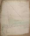
A survey of Cloncarlon [Cloncarlin or Glebe island] parish of Monasterevin County of Kildare, the estate of the most noble Charles Marquis Drogheda. Surveyed by J. Longfield on the part of the Marquis of Drogheda and Clarges Green on the part of John Cassidy August, 1817. Scale 16 perches to an inch. Notes on differences in surveys & references to lease.
Map
Main Creator:
Longfield
,
John
,
ca
.
1775
-
1833
,
surveyor
Language:
English
Format:
Map
In collection:
Longfield Map Collection
Published / Created
[August 1817]
Notes
Physical description: 1 map Geographic Coverage: Par...
Call Number:
Loading...
Located:
Loading...
A map of the bog of Cloonegad [Clonegath] in the County of Kildare shewing the situation and extent of the several turf banks occupied by sundry tenants of the most noble Charles Marquis of Drogheda. By J.L. 1811.
Map
Main Creator:
Longfield
,
John
,
ca
.
1775
-
1833
,
surveyor
Language:
English
Format:
Map
In collection:
Longfield Map Collection
Published / Created
[1811]
Notes
Physical description: 1 map Geographic Coverage: Bar...
Call Number:
Loading...
Located:
Loading...
A survey of the lands & bogs of Cloncarlon [Cloncarlin] near Monasterevin in the County of Kildare occupied by John Cassidy. By J.L. 1815. Scale 16 perches to an inch. Table of reference showing area of profitable and cutaway bog.
Map
Main Creator:
Longfield
,
John
,
ca
.
1775
-
1833
,
surveyor
Language:
English
Format:
Map
In collection:
Longfield Map Collection
Published / Created
[1815]
Notes
Physical description: 1 map Geographic Coverage: Bar...
Call Number:
Loading...
Located:
Loading...
A survey of the town of Monasterevin done with a view to shew the advantage & improvement of changing the bridge from its present site so as to range with the main entrance from Dublin. By John Longfield, 1807. Scale 100 feet to an inch. Names of some tenants shown on properties.
Map
Main Creator:
Longfield
,
John
,
ca
.
1775
-
1833
,
surveyor
Language:
English
Format:
Map
In collection:
Longfield Map Collection
Published / Created
[1807]
Notes
Physical description: 1 map Geographic Coverage: Bar...
Call Number:
Loading...
Located:
Loading...
A map of part of the Town Parks of Monasterevin, west of the river Barrow, the estate of the most noble Charles Marquis of Drogheda. Survey'd by J.L. 1806. Scale 10 perches to an inch. Names of adjoining tenants shown.
Map
Main Creator:
Longfield
,
John
,
ca
.
1775
-
1833
,
surveyor
Language:
English
Format:
Map
In collection:
Longfield Map Collection
Published / Created
[1806]
Notes
Physical description: 1 map Geographic Coverage: Bar...
Call Number:
Loading...
Located:
Loading...
A survey of part of the lands of Hybla [or Ballyreage] in the barony of Ophaly and County of Kildare belonging to Howard Moore. Surveyed by J.L. 1813. Scale 20 perches to an inch.
Map
Main Creator:
Longfield
,
John
,
ca
.
1775
-
1833
,
surveyor
Language:
English
Format:
Map
In collection:
Longfield Map Collection
Published / Created
[1813]
Notes
Physical description: 1 map Geographic Coverage: Bar...
Call Number:
Loading...
Located:
Loading...
A survey of the town of Monasterevin done with a view to shew the advantage & improvement of changing the bridge from its present site so as to range with the main entrance from Dublin. By John Longfield, 1807. Scale 100 feet to an inch.
Map
Main Creator:
Longfield
,
John
,
ca
.
1775
-
1833
,
surveyor
Language:
English
Format:
Map
In collection:
Longfield Map Collection
Published / Created
[1807]
Notes
Physical description: 1 map Geographic Coverage: Bar...
Call Number:
Loading...
Located:
Loading...
A map of Fearmoor [Fearmore] in the Barony of Offaly West and County of Kildare the estate of the Marquis of Drogheda. By John Longfield 1815. Scale 20 perches to an inch. Names of tenants and acreage of holdings shown.
Map
Main Creator:
Longfield
,
John
,
ca
.
1775
-
1833
,
surveyor
Language:
English
Format:
Map
In collection:
Longfield Map Collection
Published / Created
[1815]
Notes
Inset map: "A map of the lands of Grangecoor in the B...
Call Number:
Loading...
Located:
Loading...
[A map of] part of the bog of Monavollagh. Surveyed for the most noble the Marquis of Drogheda by John Longfield 1815.
Map
Main Creator:
Longfield
,
John
,
ca
.
1775
-
1833
,
surveyor
Language:
English
Format:
Map
In collection:
Longfield Map Collection
Published / Created
[1815]
Notes
Physical description: 1 map Geographic Coverage: Bar...
Call Number:
Loading...
Located:
Loading...
[Map of] reduction of part of Rickardstown [in the Barony of Offaly West and County of Kildare] done for Dominick O Reilly & surveyed 1816. By J.L. Scale 10 perches to an inch.
Map
Main Creator:
Longfield
,
John
,
ca
.
1775
-
1833
,
surveyor
Language:
English
Format:
Map
In collection:
Longfield Map Collection
Published / Created
[1816]
Notes
Physical description: 1 map Geographic Coverage: Bar...
Call Number:
Loading...
Located:
Loading...
A map of a give and take line between Cloneygath [Clonegath] the estgate of the most noble Charles Marquis of Drogheda & Kildangan the estate of Dominick O Reilly situate near Monasterevin in the County of Kildare. Surveyed and laid out by J.L. 1817.
Map
Main Creator:
Longfield
,
John
,
ca
.
1775
-
1833
,
surveyor
Language:
English
Format:
Map
In collection:
Longfield Map Collection
Published / Created
[1817]
Notes
Inset map: "Map of part of Rickardstown and part of K...
Call Number:
Loading...
Located:
Loading...
[A map of] Rathmuck in the barony of west Ophaly and County of Kildare the estate of Dominick O Reilly. Surveyed April 9th 1818 By J.L.
Map
Main Creator:
Longfield
,
John
,
ca
.
1775
-
1833
,
surveyor
Language:
English
Format:
Map
In collection:
Longfield Map Collection
Published / Created
[April 19 1818]
Notes
Physical description: 1 map Geographic Coverage: Bar...
Call Number:
Loading...
Located:
Loading...
Get RSS Feed
Email this Search
History
Narrow Search
Digitised
Remove Filters
Clear Filter
Region: Offaly West (Barony)
Format
16
Map
Online Availability
15
Digitised
1
Not Digitised
Published / Created
From:
To:
Subject
16
Administration of estates
16
Boundaries (Estates)
16
Land tenure
16
Land use surveys
Author
16
Longfield, John, ca. 1775-1833, surveyor
Collections
16
Longfield Map Collection
Language
16
English
Genre
16
Manuscript maps
16
Maps, Manuscript
Region
16
Ireland
16
Kildare (County)
16
Kildare (Ireland : County)
Offaly West (Barony)
1
Monasterevin Parish
1
Monasterevin Parish (Ireland)
Loading...
![A map of the lands of Oughill [Oghil] in the barony of Ophaley [Offaly] west and County of Kildare the estate of the most noble Charles Marquis of Drogheda. Surveyed by John Longfield 1816. Names of tenants and acreage of holdings shown.](/IIIF/000310000/000302067/vtls000302067_001.jp2/full/100,/0/default.jpg)
![A map of a piece of ground [now a plantation] adjoining the concerns of John Cassidy in Monasterevin, the estate of Charles Marquis of Drogheda. Surveyed September 1806. By J.L. Scale 42 feet to an inch.](/IIIF/000310000/000302176/vtls000302176_001.jp2/full/100,/0/default.jpg)

![A survey of Cloncarlon [Cloncarlin or Glebe island] parish of Monasterevin County of Kildare, the estate of the most noble Charles Marquis Drogheda. Surveyed by J. Longfield on the part of the Marquis of Drogheda and Clarges Green on the part of John Cassidy August, 1817. Scale 16 perches to an inch. Notes on differences in surveys & references to lease.](/IIIF/000310000/000302188/vtls000302188_001.jp2/full/100,/0/default.jpg)
![A map of the bog of Cloonegad [Clonegath] in the County of Kildare shewing the situation and extent of the several turf banks occupied by sundry tenants of the most noble Charles Marquis of Drogheda. By J.L. 1811.](/IIIF/000310000/000302206/vtls000302206_001.jp2/full/100,/0/default.jpg)
![A survey of the lands & bogs of Cloncarlon [Cloncarlin] near Monasterevin in the County of Kildare occupied by John Cassidy. By J.L. 1815. Scale 16 perches to an inch. Table of reference showing area of profitable and cutaway bog.](/IIIF/000310000/000302062/vtls000302062_001.jp2/full/100,/0/default.jpg)

![A survey of part of the lands of Hybla [or Ballyreage] in the barony of Ophaly and County of Kildare belonging to Howard Moore. Surveyed by J.L. 1813. Scale 20 perches to an inch.](/IIIF/000310000/000302221/vtls000302221_001.jp2/full/100,/0/default.jpg)

![A map of Fearmoor [Fearmore] in the Barony of Offaly West and County of Kildare the estate of the Marquis of Drogheda. By John Longfield 1815. Scale 20 perches to an inch. Names of tenants and acreage of holdings shown.](/IIIF/000310000/000302218/vtls000302218_001.jp2/full/100,/0/default.jpg)
![[A map of] part of the bog of Monavollagh. Surveyed for the most noble the Marquis of Drogheda by John Longfield 1815.](/IIIF/000310000/000302061/vtls000302061_001.jp2/full/100,/0/default.jpg)
![[Map of] reduction of part of Rickardstown [in the Barony of Offaly West and County of Kildare] done for Dominick O Reilly & surveyed 1816. By J.L. Scale 10 perches to an inch.](/IIIF/000310000/000302225/vtls000302225_001.jp2/full/100,/0/default.jpg)
![A map of a give and take line between Cloneygath [Clonegath] the estgate of the most noble Charles Marquis of Drogheda & Kildangan the estate of Dominick O Reilly situate near Monasterevin in the County of Kildare. Surveyed and laid out by J.L. 1817.](/IIIF/000310000/000302223/vtls000302223_001.jp2/full/100,/0/default.jpg)
![[A map of] Rathmuck in the barony of west Ophaly and County of Kildare the estate of Dominick O Reilly. Surveyed April 9th 1818 By J.L.](/IIIF/000310000/000302094/vtls000302094_001.jp2/full/100,/0/default.jpg)