Showing
1 - 1
results of
1
for search '
Brownrigg, Longfield and Murray, fl. 1799-ca. 1805, surveyors
'
Skip to content
Toggle navigation
NLI Website
- Catalogue -
English
Gaeilge
Home
Help
Advanced Search
Browse
Orders
Ask a Librarian
Language
English
Gaeilge
All Fields
Title
Author
Subject
Call Number
ISBN/ISSN
Publisher
Coordinates
Search digitised content only
FIND
Author
Brownrigg, Longfield and Murray, fl. 1799-ca. 1805, surveyors
Results
Showing
1 - 1
results of
1
for search '
Brownrigg, Longfield and Murray, fl. 1799-ca. 1805, surveyors
'
, query time: 0.04s
List
Grid
Sort
Relevance
Newest First
Oldest First
Call Number
Author
Title
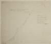
A map of an intended line of new Road between the Towns of Mallahide & Swords in the County of Dublin. Survey'd by Brownrigg Longfield & Murray. Scale 20 Perches to an Inch
Map
Main Creator:
Brownrigg
,
Longfield
and
Murray
,
fl
.
1799
-
ca
.
1805
,
surveyors
Language:
English
Format:
Map
In collection:
Longfield Map Collection
Published / Created
[between 1799 and 1805]
Notes
Physical description: 1 map Geographic Coverage: Bar...
Call Number:
Loading...
Located:
Loading...
Get RSS Feed
Email this Search
History
Narrow Search
Digitised
Remove Filters
Clear Filter
Region: Coolock (Barony)
Format
1
Map
Online Availability
1
Digitised
Published / Created
From:
To:
Subject
1
Administration of estates
1
Boundaries (Estates)
1
Land tenure
1
Land use surveys
Author
1
Brownrigg, Longfield and Murray, fl. 1799-ca. 1805, surveyors
Collections
1
Longfield Map Collection
Language
1
English
Genre
1
Manuscript maps
1
Maps, Manuscript
Region
Coolock (Barony)
1
Dublin (County)
1
Dublin (Ireland : County)
1
Ireland
Loading...