Showing
1 - 20
results of
118
for search '
Longfield, Robert Ormsby, 1844-1908, donor
'
Skip to content
Toggle navigation
NLI Website
- Catalogue -
English
Gaeilge
Home
Help
Advanced Search
Browse
Orders
Ask a Librarian
Language
English
Gaeilge
All Fields
Title
Author
Subject
Call Number
ISBN/ISSN
Publisher
Coordinates
Search digitised content only
FIND
Author
Longfield, Robert Ormsby, 1844-1908, donor
Results
Showing
1 - 20
results of
118
for search '
Longfield, Robert Ormsby, 1844-1908, donor
'
, query time: 0.04s
List
Grid
Sort
Relevance
Newest First
Oldest First
Call Number
Author
Title
1
2
3
4
5
6
Next
6
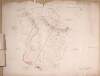
A map of lands at Cloondart in the barony of Frenchpark and County of Roscommon. James Grady & Co shown as proprietors.
Map
Language:
English
Format:
Map
In collection:
Longfield Map Collection
Published / Created
[between 1770 and 1840]
Notes
Physical description: 1 map Geographic Coverage: Bar...
Contributors:
“
...
Longfield
,
Robert
Ormsby
,
1844
-
1908
,
donor
...
”
Call Number:
Loading...
Located:
Loading...
A survey of lands at Drumsillagh, Loughill and Kilmacarril and the island of Inishatirra in the barony of Boyle and County of Roscommon. Names of tenants and acreage of holdings shown.
Map
Language:
English
Format:
Map
In collection:
Longfield Map Collection
Published / Created
[between 1770 and 1840]
Notes
Physical description: 1 map Geographic Coverage: Bar...
Contributors:
“
...
Longfield
,
Robert
Ormsby
,
1844
-
1908
,
donor
...
”
Call Number:
Loading...
Located:
Loading...
A map of part of the estate of Cloonalis in the parish of Kilkeevin barony of Castlereagh and County of Roscommon. Surveyed in April 1805 by Andrew Kelly.
Map
Main Creator:
Kelly, Andrew, fl. 1805, surveyor
Language:
English
Format:
Map
In collection:
Longfield Map Collection
Published / Created
[April 1805]
Notes
Physical description: 1 map Geographic Coverage: Par...
Contributors:
“
...
Longfield
,
Robert
Ormsby
,
1844
-
1908
,
donor
...
”
Call Number:
Loading...
Located:
Loading...
A survey of part of the lands of Moyvannan in the barony of Athlone and County of Roscommon the estate of Col. F. W. French M.P. Surveyed by J.L. 1825. Scale 16 perches to an inch. Owen Ward's allotment shown.
Map
Main Creator:
Longfield, John, ca. 1775-1833, surveyor
Language:
English
Format:
Map
In collection:
Longfield Map Collection
Published / Created
[1825]
Notes
Physical description: 1 map Geographic Coverage: Bar...
Contributors:
“
...
Longfield
,
Robert
Ormsby
,
1844
-
1908
,
donor
...
”
Call Number:
Loading...
Located:
Loading...
A survey of Tully in the barony of Castlereagh and County of Roscommon. Scale 20 perches to an inch. Names of tenants and acreage of holdings shown.
Map
Language:
English
Format:
Map
In collection:
Longfield Map Collection
Published / Created
[between 1770 and 1840]
Notes
Physical description: 1 map Geographic Coverage: Bar...
Contributors:
“
...
Longfield
,
Robert
Ormsby
,
1844
-
1908
,
donor
...
”
Call Number:
Loading...
Located:
Loading...
A map of Boxford and Cams in the County of Roscommon. March 1829. Scale 20 perches to an inch. Names of tenants and acreage of holdings shown.
Map
Language:
English
Format:
Map
In collection:
Longfield Map Collection
Published / Created
[March 1829]
Notes
Physical description: 1 map Geographic Coverage: Bar...
Contributors:
“
...
Longfield
,
Robert
Ormsby
,
1844
-
1908
,
donor
...
”
Call Number:
Loading...
Located:
Loading...
A map of lands at Cloonfad in the barony of Frenchpark and County Roscommon. Names of tenants and acreage of holdings shown.
Map
Language:
English
Format:
Map
In collection:
Longfield Map Collection
Published / Created
[between 1770 and 1840]
Notes
Physical description: 1 map Geographic Coverage: Bar...
Contributors:
“
...
Longfield
,
Robert
Ormsby
,
1844
-
1908
,
donor
...
”
Call Number:
Loading...
Located:
Loading...
A punctual and exact plan of Clooncah ... and Derry then qualities and quantities according to the bounds traced by Edmond Kenny, Peter Henry and John Dillon. Surveyed at the instance of Capt. French of Frenchpark laid down by a scale of 40 perches to an inch in October 1753. By James Costello. Table of reference showing acreage & description of lands.
Map
Main Creator:
Costello, James, fl. 1753-1787, surveyor
Language:
English
Format:
Map
In collection:
Longfield Map Collection
Published / Created
[October 1753]
Notes
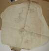
Map is quite faded. Physical description: 1 map Geog...
Contributors:
“
...
Longfield
,
Robert
Ormsby
,
1844
-
1908
,
donor
...
”
Call Number:
Loading...
Located:
Loading...
A survey of Aghagad and Buckfield situate in the County of Roscommon part of the estate of St. George Caulfield. By Michael Cuddehy March 1803. Scale of 20 perches to an inch. Table of reference showing allotments and names of tenants.
Map
Main Creator:
Cuddehy, Michael, fl. 1791-1803, surveyor
Language:
English
Format:
Map
In collection:
Longfield Map Collection
Published / Created
[March 1803]
Notes
Physical description: 1 map Geographic Coverage: Bar...
Contributors:
“
...
Longfield
,
Robert
Ormsby
,
1844
-
1908
,
donor
...
”
Call Number:
Loading...
Located:
Loading...
A survey of Termon More and Moor in the barony of Castlereagh and County of Roscommon. Names of tenants and acreage of holdings shown.
Map
Language:
English
Format:
Map
In collection:
Longfield Map Collection
Published / Created
[between 1770 and 1840]
Notes
Physical description: 1 map Geographic Coverage: Bar...
Contributors:
“
...
Longfield
,
Robert
Ormsby
,
1844
-
1908
,
donor
...
”
Call Number:
Loading...
Located:
Loading...
A map of lands at Buckill in the barony of Frenchpark and County of Roscommon. Names of tenants and acreage of holdings shown.
Map
Language:
English
Format:
Map
In collection:
Longfield Map Collection
Published / Created
[between 1770 and 1840]
Notes
Physical description: 1 map Geographic Coverage: Bar...
Contributors:
“
...
Longfield
,
Robert
Ormsby
,
1844
-
1908
,
donor
...
”
Call Number:
Loading...
Located:
Loading...
A map of lands at Tully ... and Figh in the barony of Frenchpark and County of Roscommon. Scale of 80 perches to an inch.
Map
Language:
English
Format:
Map
In collection:
Longfield Map Collection
Published / Created
[between 1770 and 1840]
Notes
Physical description: 1 map Geographic Coverage: Bar...
Contributors:
“
...
Longfield
,
Robert
Ormsby
,
1844
-
1908
,
donor
...
”
Call Number:
Loading...
Located:
Loading...
A survey of lands at Derryquirk Ardkeenagh Aghloonagh Grange and Tulsk in the barony and County of Roscommon. Scale 16 perches to an inch. Names of tenants and acreage of holdings shown.
Map
Language:
English
Format:
Map
In collection:
Longfield Map Collection
Published / Created
[between 1770 and 1840]
Notes
Physical description: 1 map Geographic Coverage: Bar...
Contributors:
“
...
Longfield
,
Robert
Ormsby
,
1844
-
1908
,
donor
...
”
Call Number:
Loading...
Located:
Loading...
A map of Rooaun in the barony of Ballintober North and County of Roscommon. Mrs. Norton shown as tenant acreage also shown.
Map
Language:
English
Format:
Map
In collection:
Longfield Map Collection
Published / Created
[between 1770 and 1840]
Notes
Physical description: 1 map Geographic Coverage: Bar...
Contributors:
“
...
Longfield
,
Robert
Ormsby
,
1844
-
1908
,
donor
...
”
Call Number:
Loading...
Located:
Loading...
A map of the lands of Carrowreagh and Peak in the barony of Castlereagh and County of Roscommon. Names of tenants and acreage of holdings shown.
Map
Language:
English
Format:
Map
In collection:
Longfield Map Collection
Published / Created
[between 1770 and 1840]
Notes
Physical description: 1 map Geographic Coverage: Bar...
Contributors:
“
...
Longfield
,
Robert
Ormsby
,
1844
-
1908
,
donor
...
”
Call Number:
Loading...
Located:
Loading...
A map of lands at Carrigeenagappul ... in the barony and County of Roscommon. Names of tenants shown. Scale 40 perches to an inch.
Map
Language:
English
Format:
Map
In collection:
Longfield Map Collection
Published / Created
[between 1770 and 1840]
Notes
Physical description: 1 map Geographic Coverage: Bar...
Contributors:
“
...
Longfield
,
Robert
Ormsby
,
1844
-
1908
,
donor
...
”
Call Number:
Loading...
Located:
Loading...
A map of lands at Curraghard ... and Cloontowart in the barony of Frenchpark and County of Roscommon. Table of reference showing townlands & acreage & condition of lands.
Map
Language:
English
Format:
Map
In collection:
Longfield Map Collection
Published / Created
[between 1770 and 1840]
Notes
Physical description: 1 map Geographic Coverage: Bar...
Contributors:
“
...
Longfield
,
Robert
Ormsby
,
1844
-
1908
,
donor
...
”
Call Number:
Loading...
Located:
Loading...
A map of the wood of Equity and of lands at Newtown Kilcashel in the barony of Moycarn and County of Roscommon. Scale 20 perches to an inch.
Map
Language:
English
Format:
Map
In collection:
Longfield Map Collection
Published / Created
[between 1770 and 1840]
Notes
Physical description: 1 map Geographic Coverage: Bar...
Contributors:
“
...
Longfield
,
Robert
Ormsby
,
1844
-
1908
,
donor
...
”
Call Number:
Loading...
Located:
Loading...
A map of lands at Cooldornagh Ballymintan Tirconnellbeg and Milltown in the barony of Athlone and County of Roscommon. Names of tenants and acreage of holdings shown.
Map
Language:
English
Format:
Map
In collection:
Longfield Map Collection
Published / Created
[between 1770 and 1840]
Notes
Physical description: 1 map Geographic Coverage: Bar...
Contributors:
“
...
Longfield
,
Robert
Ormsby
,
1844
-
1908
,
donor
...
”
Call Number:
Loading...
Located:
Loading...
A map of lands at Cornalara Dangan and Corry in the barony of Ballintober North and County of Roscommon. Scale 20 perches to an inch. Names of tenants and acreage of holdings shown.
Map
Language:
English
Format:
Map
In collection:
Longfield Map Collection
Published / Created
[between 1770 and 1840]
Notes
Physical description: 1 map Geographic Coverage: Bar...
Contributors:
“
...
Longfield
,
Robert
Ormsby
,
1844
-
1908
,
donor
...
”
Call Number:
Loading...
Located:
Loading...
1
2
3
4
5
6
Next
6
Get RSS Feed
Email this Search
History
Narrow Search
Digitised
Remove Filters
Clear Filter
Subject: Land tenure
Clear Filter
Region: Roscommon (County)
Format
118
Map
Online Availability
111
Digitised
7
Not Digitised
Published / Created
From:
To:
Subject
118
Administration of estates
118
Boundaries (Estates)
Land tenure
118
Land use surveys
10
History
Author
7
Longfield, John, ca. 1775-1833, surveyor
2
Cuddehy, Michael, fl. 1791-1803, surveyor
2
Donlevy, Bryan, fl. 1784-1792, surveyor
2
Mulvihill, Peter, ca. 1736-d. 1798, surveyor
1
Balfe, M., fl. 1821, surveyor
1
Boyd, Joseph, fl. 1780-1807, surveyor
more ...
1
Brownrigg, Longfield and Murray, fl. 1799-ca. 1805, surveyors
1
Connolly, John, fl. 1826, surveyor
1
Costello, James, fl. 1753-1787, surveyor
1
Cuttle, Thomas (I), fl. 1722-d. 1769
1
Kelly, Andrew, fl. 1805, surveyor
1
Kelly, Martin T., fl. 1808, surveyor
1
Kirrilly, Bryan, fl. 1715-1716, surveyor
1
Longfield, William, fl. 1825-ca. 1870, surveyor
1
Simpson, Edward, fl. 1770-1804, surveyor
see all ...
less ...
Collections
118
Longfield Map Collection
Language
118
English
Genre
118
Manuscript maps
118
Maps, Manuscript
10
Early works to 1800
Era
10
18th century
Region
118
Ireland
Roscommon (County)
118
Roscommon (Ireland : County)
40
Frenchpark (Barony)
22
Castlereagh (Barony)
15
Athlone (Barony)
more ...
14
Boyle (Barony)
7
Ballintober South (Barony)
7
Roscommon (Barony)
6
Ballymoe (Barony)
5
Ballintober North (Barony)
3
Moycarn (Barony)
1
Athlone South (Barony)
1
Kilcolagh Parish
1
Kilcolagh Parish (Ireland)
1
Kilglass Parish
1
Kilglass Parish (Ireland)
1
Kilkeevin Parish
1
Kilkeevin Parish (Ireland)
1
Kilmeane Parish
1
Kilmeane Parish (Ireland)
1
Tibohine Parish
1
Tibohine Parish (Ireland)
1
Tilohine Parish
1
Tilohine Parish (Ireland)
see all ...
less ...
Loading...