Showing
1 - 20
results of
45
for search '
Longfield, Robert Ormsby, 1844-1908, donor
'
Skip to content
Toggle navigation
NLI Website
- Catalogue -
English
Gaeilge
Home
Help
Advanced Search
Browse
Orders
Ask a Librarian
Language
English
Gaeilge
All Fields
Title
Author
Subject
Call Number
ISBN/ISSN
Publisher
Coordinates
Search digitised content only
FIND
Author
Longfield, Robert Ormsby, 1844-1908, donor
Results
Showing
1 - 20
results of
45
for search '
Longfield, Robert Ormsby, 1844-1908, donor
'
, query time: 0.06s
List
Grid
Sort
Relevance
Newest First
Oldest First
Call Number
Author
Title
1
2
3
Next
3
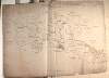
[A map of Legmacaffrey Aghnahinch Leitrim and other townlands in the Barony of Coole County Fermanagh]. Scale 20 perches to an inch. Names of tenants with acreage shown on holdings.
Map
Language:
English
Format:
Map
In collection:
Longfield Map Collection
Published / Created
[between 1770 and 1840]
Notes
Physical description: 1 map Geographic Coverage: Bar...
Contributors:
“
...
Longfield
,
Robert
Ormsby
,
1844
-
1908
,
donor
...
”
Call Number:
Loading...
Located:
Loading...
A map of the Lands of Coolnacran and village of Loughbrickland in the County of Down.
Map
Language:
English
Format:
Map
In collection:
Longfield Map Collection
Published / Created
[between 1770 and 1840]
Notes
Some staining at the edges of the map. Physical descr...
Contributors:
“
...
Longfield
,
Robert
Ormsby
,
1844
-
1908
,
donor
...
”
Call Number:
Loading...
Located:
Loading...
A map of part of the estate of James Stewart situate in the barony of Dungannon and parish of Arboe County Tyrone. Surveyed in 1803 included are the the townlands of Anneeter Beg, Anneeter More, Ardean, Cluntoe [Richardson], Lurgyroe, Kinrush ... and Killycanavan. Names of tenants and area of holdings shown.
Map
Language:
English
Format:
Map
In collection:
Longfield Map Collection
Published / Created
[1803]
Notes
Physical description: 1 map Geographic Coverage: Par...
Contributors:
“
...
Longfield
,
Robert
Ormsby
,
1844
-
1908
,
donor
...
”
Call Number:
Loading...
Located:
Loading...
A map of the manor of Clare in the County of Armagh & Kingdom of Ireland, the Estate of the Rt. Honourable John Earl of Sandwich & Peter De Sales Esq. Reduced from R. Brassingtons survey by Jn.. Longfield, 1805.
Map
Main Creator:
Longfield, John, ca. 1775-1833, surveyor
Language:
English
Format:
Map
In collection:
Longfield Map Collection
Published / Created
[1805]
Notes
Physical description: 1 map Geographic Coverage: Par...
Contributors:
“
...
Longfield
,
Robert
Ormsby
,
1844
-
1908
,
donor
...
”
Call Number:
Loading...
Located:
Loading...
An outline map of holdings at Tullynasoo in the County Down and the barony of Iveagh Upper lower half. Table of reference showing tenants & acreage of holdings.
Map
Language:
English
Format:
Map
In collection:
Longfield Map Collection
Published / Created
[between 1770 and 1840]
Notes
In poor condition. Map is in two pieces, torn and sta...
Contributors:
“
...
Longfield
,
Robert
Ormsby
,
1844
-
1908
,
donor
...
”
Call Number:
Loading...
Located:
Loading...
A survey of Newtown Butler with the neighbouring lands in the County of Fermanagh. Scale 20 perches to an inch. Table of reference showing tenants names & acreage of holdings.
Map
Language:
English
Format:
Map
In collection:
Longfield Map Collection
Published / Created
[between 1770 and 1840]
Notes
Physical description: 1 map Geographic Coverage: Bar...
Contributors:
“
...
Longfield
,
Robert
Ormsby
,
1844
-
1908
,
donor
...
”
Call Number:
Loading...
Located:
Loading...
A map and survey of Ballipheras, situate in the parish of St. Andrews, Barony of Ards and County of Down, the Estate of Sir James Blackwood & Francis Savage Esq. Surveyed in Oct 1803.
Map
Language:
English
Format:
Map
In collection:
Longfield Map Collection
Published / Created
[October 1803]
Notes
Physical description: 1 map Geographic Coverage: Par...
Contributors:
“
...
Longfield
,
Robert
Ormsby
,
1844
-
1908
,
donor
...
”
Call Number:
Loading...
Located:
Loading...
A map of lands at Drummond, Crossdermot, Mulnagore, Curlonan, Moree, Drumballyhugh ... and Moynagh in the barony of Dungannon Upper and County of Tyrone. Names of tenants and acreage of holdings shown.
Map
Language:
English
Format:
Map
In collection:
Longfield Map Collection
Published / Created
[between 1770 and 1840]
Notes
Physical description: 1 map Geographic Coverage: Bar...
Contributors:
“
...
Longfield
,
Robert
Ormsby
,
1844
-
1908
,
donor
...
”
Call Number:
Loading...
Located:
Loading...
Maps of pt. of Wm. White's Estate near Loughbrickland, 1804
Map
Language:
English
Format:
Map
In collection:
Longfield Map Collection
Published / Created
[1804]
Notes
Physical description: 1 map Geographic Coverage: Bar...
Contributors:
“
...
Longfield
,
Robert
Ormsby
,
1844
-
1908
,
donor
...
”
Call Number:
Loading...
Located:
Loading...
[A map of ] Ennuch in the Lower half Barony of Ossier and County Armagh the Estate of the Rep. of Saml. Hanna Esq. Let to Mr. Norris.
Map
Language:
English
Format:
Map
In collection:
Longfield Map Collection
Published / Created
[between 1770 and 1840]
Notes
Physical description: 1 map Geographic Coverage: Par...
Contributors:
“
...
Longfield
,
Robert
Ormsby
,
1844
-
1908
,
donor
...
”
Call Number:
Loading...
Located:
Loading...
An outline map of lands in Drumnahane, Co Down 1803
Map
Language:
English
Format:
Map
In collection:
Longfield Map Collection
Published / Created
[1803]
Notes
Physical description: 1 map Geographic Coverage: Bar...
Contributors:
“
...
Longfield
,
Robert
Ormsby
,
1844
-
1908
,
donor
...
”
Call Number:
Loading...
Located:
Loading...
[A survey of the townlands of Duckery, Tullyear and Ballydown, in the Barony of Iveagh, Upper and County of Down]
Map
Language:
English
Format:
Map
In collection:
Longfield Map Collection
Published / Created
[between 1770 and 1840]
Notes
Physical description: 1 map Geographic Coverage: Bar...
Contributors:
“
...
Longfield
,
Robert
Ormsby
,
1844
-
1908
,
donor
...
”
Call Number:
Loading...
Located:
Loading...
[A map of Gubh and other townlands in County Fermanagh]. Names of tenants acreage shown
Map
Language:
English
Format:
Map
In collection:
Longfield Map Collection
Published / Created
[between 1770 and 1840]
Notes
Physical description: 1 map Geographic Coverage: Cou...
Contributors:
“
...
Longfield
,
Robert
Ormsby
,
1844
-
1908
,
donor
...
”
Call Number:
Loading...
Located:
Loading...
Map of part of Ballymagrorty, part of the lands of Shantalla in the County of Derry & properties in Derry city. Names of tenants & area of holdings shown.
Map
Language:
English
Format:
Map
In collection:
Longfield Map Collection
Published / Created
[between 1770 and 1840]
Notes
Physical description: 1 map Geographic Coverage: Der...
Contributors:
“
...
Longfield
,
Robert
Ormsby
,
1844
-
1908
,
donor
...
”
Call Number:
Loading...
Located:
Loading...
[A map of Coragleck County Fermanagh]. Names of proprietors & acres of holdings shown
Map
Language:
English
Format:
Map
In collection:
Longfield Map Collection
Published / Created
[between 1770 and 1840]
Notes
Physical description: 1 map Geographic Coverage: Bar...
Contributors:
“
...
Longfield
,
Robert
Ormsby
,
1844
-
1908
,
donor
...
”
Call Number:
Loading...
Located:
Loading...
A map of Tullaghmore Ross Lurgy and Sherrigrin in the barony of Dungannon Middle and County Tyrone the estate of James Stewart 1798. Scale 20 perches to an inch. Names of tenants & acreage of holdings shown.
Map
Language:
English
Format:
Map
In collection:
Longfield Map Collection
Published / Created
[1798]
Notes
Physical description: 1 map Geographic Coverage: Bar...
Contributors:
“
...
Longfield
,
Robert
Ormsby
,
1844
-
1908
,
donor
...
”
Call Number:
Loading...
Located:
Loading...
A map of lands at Clonavaddy and Aghaginduff in the barony of Dungannon Middle and County of Tyrone. Table of reference showing tenants acreage of holdings and condition of land.
Map
Language:
English
Format:
Map
In collection:
Longfield Map Collection
Published / Created
[between 1770 and 1840]
Notes
Physical description: 1 map Geographic Coverage: Bar...
Contributors:
“
...
Longfield
,
Robert
Ormsby
,
1844
-
1908
,
donor
...
”
Call Number:
Loading...
Located:
Loading...
[A map of] Part of the townland of Ballymuckateer [Ballymacaton] in the Parish of Magheralin, Barony of Lower Iveagh, Co Down. 1828.
Map
Language:
English
Format:
Map
In collection:
Longfield Map Collection
Published / Created
[1828]
Notes
Physical description: 1 map Geographic Coverage: Par...
Contributors:
“
...
Longfield
,
Robert
Ormsby
,
1844
-
1908
,
donor
...
”
Call Number:
Loading...
Located:
Loading...
A map of lands at Kilcronagh Ballyreagh Knockacunny Annaghmore Annaghananam and Annaghteigh in the barony of Dungannon Upper and County of Tyrone. Names of tenants and acreage of holdings shown.
Map
Language:
English
Format:
Map
In collection:
Longfield Map Collection
Published / Created
[between 1770 and 1840]
Notes
Physical description: 1 map Geographic Coverage: Bar...
Contributors:
“
...
Longfield
,
Robert
Ormsby
,
1844
-
1908
,
donor
...
”
Call Number:
Loading...
Located:
Loading...
A map of part of Archerstown in the barony of Delvin and County of Westmeath the estate of William Smyth let to John Nugent ... Sept. 1786.
Map
Language:
English
Format:
Map
In collection:
Longfield Map Collection
Published / Created
[September 1786]
Notes
Inset map: "Widow Donegan's part of Cackinish in the...
Contributors:
“
...
Longfield
,
Robert
Ormsby
,
1844
-
1908
,
donor
...
”
Call Number:
Loading...
Located:
Loading...
1
2
3
Next
3
Get RSS Feed
Email this Search
History
Narrow Search
Digitised
Remove Filters
Clear Filter
Subject: Boundaries (Estates)
Clear Filter
Region: Northern Ireland
Format
45
Map
Online Availability
39
Digitised
6
Not Digitised
Published / Created
From:
To:
Subject
45
Administration of estates
Boundaries (Estates)
45
Land tenure
45
Land use surveys
5
History
Author
3
Longfield, John, ca. 1775-1833, surveyor
1
Brownrigg, Longfield and Murray, fl. 1799-ca. 1805, surveyors
Collections
45
Longfield Map Collection
Language
45
English
Genre
45
Manuscript maps
45
Maps, Manuscript
5
Early works to 1800
Era
5
18th century
Region
Northern Ireland
18
Down (County)
18
Down (Northern Ireland : County)
12
Fermanagh (County)
12
Fermanagh (Northern Ireland : County)
8
Tyrone (County)
more ...
8
Tyrone (Northern Ireland : County)
7
Iveagh Upper (Barony)
6
Coole (Barony)
5
Iveagh Lower (Barony)
4
Dungannon Middle (Barony)
4
Knockninny (Barony)
3
Armagh (County)
3
Armagh (Northern Ireland : County)
3
Dungannon Upper (Barony)
3
Orior Lower (Barony)
2
Antrim (County)
2
Antrim (Northern Ireland : County)
2
Derry (County)
2
Derry (Northern Ireland : County)
2
Glenarm Lower (Barony)
2
Iveagh Upper, Upper Half (Barony)
1
Arboe Parish
1
Arboe Parish (Northern Ireland)
1
Ards Upper (Barony)
1
Ballymore Parish
1
Ballymore Parish (Northern Ireland)
1
Delvin (Barony)
1
Derry
1
Derry (Northern Ireland)
see all ...
less ...
Loading...
![[A map of Legmacaffrey Aghnahinch Leitrim and other townlands in the Barony of Coole County Fermanagh]. Scale 20 perches to an inch. Names of tenants with acreage shown on holdings.](/IIIF/000310000/000301946/vtls000301946_001.jp2/full/100,/0/default.jpg)

![A map of part of the estate of James Stewart situate in the barony of Dungannon and parish of Arboe County Tyrone. Surveyed in 1803 included are the the townlands of Anneeter Beg, Anneeter More, Ardean, Cluntoe [Richardson], Lurgyroe, Kinrush ... and Killycanavan. Names of tenants and area of holdings shown.](/IIIF/000310000/000302573/vtls000302573_001.jp2/full/100,/0/default.jpg)


![[A map of ] Ennuch in the Lower half Barony of Ossier and County Armagh the Estate of the Rep. of Saml. Hanna Esq. Let to Mr. Norris.](/IIIF/000310000/000301888/vtls000301888_001.jp2/full/100,/0/default.jpg)
![[A survey of the townlands of Duckery, Tullyear and Ballydown, in the Barony of Iveagh, Upper and County of Down]](/IIIF/000310000/000301931/vtls000301931_001.jp2/full/100,/0/default.jpg)
![[A map of Gubh and other townlands in County Fermanagh]. Names of tenants acreage shown](/IIIF/000310000/000301944/vtls000301944_001.jp2/full/100,/0/default.jpg)

![[A map of Coragleck County Fermanagh]. Names of proprietors & acres of holdings shown](/IIIF/000310000/000301950/vtls000301950_001.jp2/full/100,/0/default.jpg)


![[A map of] Part of the townland of Ballymuckateer [Ballymacaton] in the Parish of Magheralin, Barony of Lower Iveagh, Co Down. 1828.](/IIIF/000310000/000301939/vtls000301939_001.jp2/full/100,/0/default.jpg)

