Showing
61 - 80
results of
1,578
for search '
Longfield, Robert Ormsby, 1844-1908, donor
'
Skip to content
Toggle navigation
NLI Website
- Catalogue -
English
Gaeilge
Home
Help
Advanced Search
Browse
Orders
Ask a Librarian
Language
English
Gaeilge
All Fields
Title
Author
Subject
Call Number
ISBN/ISSN
Publisher
Coordinates
Search digitised content only
FIND
Author
Longfield, Robert Ormsby, 1844-1908, donor
Results
Showing
61 - 80
results of
1,578
for search '
Longfield, Robert Ormsby, 1844-1908, donor
'
, query time: 0.06s
List
Grid
Sort
Relevance
Newest First
Oldest First
Call Number
Author
Title
1
Previous
1
2
3
4
5
6
7
8
9
10
11
Next
79
Loading...
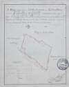
A map of Rossan Bogstown and Killaskillen Bogs in the barony of Moyfenrath Upper and County of M...
Loading...
A map of that part of the Royal Canal intended to pass through the County of Dublin from Summer...
Loading...
A map of lands at Proudstown in the barony of Skreen and County of Meath. Tenants names & acrea...
Loading...
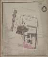
A map of Compton Domville's holding under the Dean of Christ Church April 1814. Scale 20 feet t...
Loading...
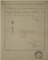
A map [illegible] "This plott of ground is under the High Court of Chancery and belongs to the V...
Loading...
[A plan of holdings in the neighbourhood of Dolphins Barn] by John Battersby 1778
Loading...
Survey of concerns between Kevin's Port and Montague Street. Names of tenants shown on properti...
Loading...
A map of part of the Glebe lands of Kilcullen in the County of Kildare, granted by the Rev. Thom...
Loading...
A map of a piece of ground on the west side of Camden Street adjoining tenant's name shown.
Loading...
A map of a lot of ground between Boyne Street and Denzile Street the property of Thomas Hamilton...
Loading...
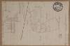
Section of river Boyne.
Loading...
Plan of north east Dublin City. Streets not named
Loading...
A map of Levallyroe in the barony of Costello and County of Mayo. Scale 20 statute perches to a...
Loading...
A plan of Monasterevin County Kildare. Names of tenants & area of holdings shown.
Loading...
A survey of part of the Lands of Dunbrow called Huntstown situate in the Barony of Coolock and C...
Loading...
A map of sundry premises on the north side of Thomas Street in the City of Dublin in the tenure...
Loading...
A map of cabins and gardens in Monasterevin. Names of tenants & area of holdings shown.
Loading...
A map of part of the lands at Kelshamore in the barony of Talbotstown Upper and County of Wicklo...
Loading...
Plan of the Brewery premises in Monasterevin County Kildare. Scale 2 perches to an inch. Table...
Loading...
A map of Barbavilla demense in the barony of Fore and County of Westmeath. Names of tenants and...
1
Previous
1
2
3
4
5
6
7
8
9
10
11
Next
79
Get RSS Feed
Email this Search
History
Narrow Search
Digitised
Remove Filters
Clear Filter
Subject: Boundaries (Estates)
Format
1,578
Map
Online Availability
954
Digitised
624
Not Digitised
Published / Created
From:
To:
Subject
Boundaries (Estates)
1,578
Land tenure
1,578
Land use surveys
1,565
Administration of estates
268
History
48
Administration of Estates
Author
335
Longfield, John, ca. 1775-1833, surveyor
112
Brownrigg, John, ca. 1748-1838, surveyor
42
Brownrigg & Co., fl. 1801-1809, surveyors
38
Longfield, William, fl. 1825-ca. 1870, surveyor
8
Reading, Thomas, ca. 1704-1779, surveyor
7
Brownrigg, Longfield and Murray, fl. 1799-ca. 1805, surveyors
more ...
6
Gartland, William, fl. 1838-1851/68, surveyor
5
Byron, Samuel, fl. 1768-1795
4
Cave, Thomas, fl. ca. 1709-1749, surveyor
4
Scalé, Brownrigg & Sherrard, fl. 1774-1778, surveyors
3
Chaloner, Samuel, fl. 1812-1833, surveyor
3
Cuddehy, Michael, fl. 1791-1803, surveyor
3
Mathews, Thomas, fl. 1760-1784, surveyor
3
Roe, John, fl. 1793-1824, surveyor
3
Scully, Patrick, fl. 1777, surveyor
3
Sherrard, Thomas, ca. 1750-1837, surveyor
2
Brownrigg & Sherrard, fl. 1777-1778, surveyors
2
Byrne, John, fl. 1789-1828, surveyor
2
Donlevy, Bryan, fl. 1784-1792, surveyor
2
Frizell, Richard, fl. 1750-1797
2
Kirrilly, Bryan, fl. 1715-1716, surveyor
2
Lewis, Robert, fl. 1745-1785, surveyor
2
Lynch, Thomas, fl. 1804-1809, surveyor
2
Moynahan, John, fl. 1736-1764, surveyor
2
Mulvihill, Peter, ca. 1736-d. 1798, surveyor
2
Neville, Arthur Richards, fl. 1775-1828, surveyor
2
Sherrard & Brassington, fl. 1800-1822, surveyors
1
Balfe, M., fl. 1821, surveyor
1
Battersby, John, fl. 1778, surveyor
1
Bell, John (I and II), fl. 1721-1820
see all ...
less ...
Collections
1,578
Longfield Map Collection
Language
1,578
English
Genre
1,578
Manuscript maps
1,577
Maps, Manuscript
269
Early works to 1800
Era
268
18th century
1
19th century
Region
1,534
Ireland
711
Dublin (Ireland : County)
710
Dublin (County)
295
Dublin (Ireland)
293
Dublin
182
Kildare (County)
more ...
182
Kildare (Ireland : County)
155
Meath
155
Meath (Ireland)
118
Roscommon (County)
118
Roscommon (Ireland : County)
111
Rathdown (Barony)
85
Coolock (Barony)
76
Offaly West (Barony)
70
Uppercross (Barony)
47
Tipperary (County)
47
Tipperary (Ireland : County)
45
Northern Ireland
43
Newcastle (Barony)
40
Frenchpark (Barony)
40
Wicklow (County)
40
Wicklow (Ireland : County)
36
Castleknock (Barony)
35
Westmeath
35
Westmeath (Ireland)
34
Balrothery (Barony)
33
Laois
33
Laois (Ireland)
31
Dublin (Barony)
29
Nethercross (Barony)
see all ...
less ...
Loading...