Showing
181 - 200
results of
1,578
for search '
Longfield, Robert Ormsby, 1844-1908, donor
'
Skip to content
Toggle navigation
NLI Website
- Catalogue -
English
Gaeilge
Home
Help
Advanced Search
Browse
Orders
Ask a Librarian
Language
English
Gaeilge
All Fields
Title
Author
Subject
Call Number
ISBN/ISSN
Publisher
Coordinates
Search digitised content only
FIND
Author
Longfield, Robert Ormsby, 1844-1908, donor
Results
Showing
181 - 200
results of
1,578
for search '
Longfield, Robert Ormsby, 1844-1908, donor
'
, query time: 0.27s
List
Grid
Sort
Relevance
Newest First
Oldest First
Call Number
Author
Title
1
Previous
5
6
7
8
9
10
11
12
13
14
15
Next
79
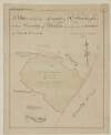
[A survey of] Part of the Lands of Glasnevin let by the Dean and Chapter of Christ Church to the Honble. Wm. John Gore. [By John Longfield]. Scale 16 Perches to an Inch
Map
Main Creator:
Longfield, John, ca. 1775-1833, surveyor
Language:
English
Format:
Map
In collection:
Longfield Map Collection
Published / Created
[between 1795 and 1833]
Notes
Physical description: 1 map Geographic Coverage: Bar...
Contributors:
“
...
Longfield
,
Robert
Ormsby
,
1844
-
1908
,
donor
...
”
Call Number:
Loading...
Located:
Loading...
A map of the village of Ballina in the barony of Owney and Arra and County of Tipperary the estate of John J. Henry. Names of tenants shown on properties.
Map
Language:
English
Format:
Map
In collection:
Longfield Map Collection
Published / Created
[between 1770 and 1840]
Notes
Physical description: 1 map Geographic Coverage: Bar...
Contributors:
“
...
Longfield
,
Robert
Ormsby
,
1844
-
1908
,
donor
...
”
Call Number:
Loading...
Located:
Loading...
A map of a piece of ground situate on the south side of Meredith Place near the Circular Road part of the estate of the Earl of Aldborough
Map
Language:
English
Format:
Map
In collection:
Longfield Map Collection
Published / Created
[between 1770 and 1840]
Notes
Physical description: 1 map Geographic Coverage: Dub...
Contributors:
“
...
Longfield
,
Robert
Ormsby
,
1844
-
1908
,
donor
...
”
Call Number:
Loading...
Located:
Loading...
A map of lands at Kilcullen in the barony of Kilcullen & barony of Naas South in County Kildare. Scale 20 perches to an inch. Names of tenants & area of holdings shown.
Map
Language:
English
Format:
Map
In collection:
Longfield Map Collection
Published / Created
[between 1770 and 1840]
Notes
Physical description: 1 map Geographic Coverage: Bar...
Contributors:
“
...
Longfield
,
Robert
Ormsby
,
1844
-
1908
,
donor
...
”
Call Number:
Loading...
Located:
Loading...
A survey of lands at Gortaganny ... and Tully in the barony of Frenchpark and County of Roscommon. Names of tenants and acreage of holdings shown.
Map
Language:
English
Format:
Map
In collection:
Longfield Map Collection
Published / Created
[between 1770 and 1840]
Notes
Physical description: 1 map Geographic Coverage: Bar...
Contributors:
“
...
Longfield
,
Robert
Ormsby
,
1844
-
1908
,
donor
...
”
Call Number:
Loading...
Located:
Loading...
A map of Ferns Demense in the barony of Scarawalsh and County of Wexford. Scale 40 perches to an inch.
Map
Language:
English
Format:
Map
In collection:
Longfield Map Collection
Published / Created
[between 1770 and 1840]
Notes
Physical description: 1 map Geographic Coverage: Bar...
Contributors:
“
...
Longfield
,
Robert
Ormsby
,
1844
-
1908
,
donor
...
”
Call Number:
Loading...
Located:
Loading...
A survey of six holdings situated in Brown Street done by order of Henry Rooke. By John Longfield 1833. Mr Faleys woollen factory & Mr Greene's holding shown
Map
Main Creator:
Longfield, John, ca. 1775-1833, surveyor
Language:
English
Format:
Map
In collection:
Longfield Map Collection
Published / Created
[1833]
Notes
Physical description: 1 map Geographic Coverage: Dub...
Contributors:
“
...
Longfield
,
Robert
Ormsby
,
1844
-
1908
,
donor
...
”
Call Number:
Loading...
Located:
Loading...
A survey of Venetian Park, in the Barony of Coolock and County of Dublin, the estate of [illegible] Vernon Esq. April 1831. Scale 10 Perches to an Inch
Map
Language:
English
Format:
Map
In collection:
Longfield Map Collection
Published / Created
[April 1831]
Notes
Physical description: 1 map Geographic Coverage: Bar...
Contributors:
“
...
Longfield
,
Robert
Ormsby
,
1844
-
1908
,
donor
...
”
Call Number:
Loading...
Located:
Loading...
A survey of lands Cloongreaghan Cootehall Moigh and Foxhill in the barony of Boyle and County of Roscommon. Scale 20 perches to an inch. Names of tenants and acreage of holdings shown.
Map
Language:
English
Format:
Map
In collection:
Longfield Map Collection
Published / Created
[between 1770 and 1840]
Notes
Physical description: 1 map Geographic Coverage: Bar...
Contributors:
“
...
Longfield
,
Robert
Ormsby
,
1844
-
1908
,
donor
...
”
Call Number:
Loading...
Located:
Loading...
A survey of part of the Lands of Gibberalter. Near the Commons of Kilmainham Surveyed 26 Sept 1793 by J.B. Scale two hundred feet to an Inch
Map
Main Creator:
Brownrigg, John, ca. 1748-1838, surveyor
Language:
English
Format:
Map
In collection:
Longfield Map Collection
Published / Created
[September 26 1793]
Notes
Physical description: 1 map Geographic Coverage: Bar...
Contributors:
“
...
Longfield
,
Robert
Ormsby
,
1844
-
1908
,
donor
...
”
Call Number:
Loading...
Located:
Loading...
A survey of part of the City of Dublin the estate of the college of the Holy and Undivided Trinity of Queen Elizabeth Dublin. By Thos. Sherrard 1781. Table of reference with lists of streets residents, allotments numbered
Map
Main Creator:
Sherrard, Thomas, ca. 1750-1837, surveyor
Language:
English
Format:
Map
In collection:
Longfield Map Collection
Published / Created
[1781]
Notes
Physical description: 1 map Geographic Coverage: Dub...
Contributors:
“
...
Longfield
,
Robert
Ormsby
,
1844
-
1908
,
donor
...
”
Call Number:
Loading...
Located:
Loading...
A survey of ground at Celbridge. April 1838. Surveyed for Mr. Longfield by WG. Table of reference names of tenants & area of properties shown.
Map
Main Creator:
Gartland, William, fl. 1838-1851/68, surveyor
Language:
English
Format:
Map
In collection:
Longfield Map Collection
Published / Created
[April 1838]
Notes
Some damage to the right-hand piece of the map which...
Contributors:
“
...
Longfield
,
Robert
Ormsby
,
1844
-
1908
,
donor
...
”
Call Number:
Loading...
Located:
Loading...
A plan of holdings at St. Stephens Green. Holding of Surgeon Collis shown.
Map
Language:
English
Format:
Map
In collection:
Longfield Map Collection
Published / Created
[between 1770 and 1840]
Notes
Physical description: 1 map Geographic Coverage: Dub...
Contributors:
“
...
Longfield
,
Robert
Ormsby
,
1844
-
1908
,
donor
...
”
Call Number:
Loading...
Located:
Loading...
A survey of Dean Hill and Harristown part of the estate of the Honble. & Rev. Richard Bourke in the barony of Skreen and County of Meath. April 1795 by John Browne. Scale 20 perches to an inch. Names of tenants & acreage of holdings shown.
Map
Main Creator:
Browne, John, fl. 1788-ca. 1807, surveyor
Language:
English
Format:
Map
In collection:
Longfield Map Collection
Published / Created
[April 1795]
Notes
Physical description: 1 map Geographic Coverage: Bar...
Contributors:
“
...
Longfield
,
Robert
Ormsby
,
1844
-
1908
,
donor
...
”
Call Number:
Loading...
Located:
Loading...
A survey of three houses in Queen Street part of the estate of the Marquis of Lansdowne. Surveyed by John Longfield 1827. Names of tenants shown on properties.
Map
Main Creator:
Longfield, John, ca. 1775-1833, surveyor
Language:
English
Format:
Map
In collection:
Longfield Map Collection
Published / Created
[1827]
Notes
Physical description: 1 map Geographic Coverage: Dub...
Contributors:
“
...
Longfield
,
Robert
Ormsby
,
1844
-
1908
,
donor
...
”
Call Number:
Loading...
Located:
Loading...
A map of part of the Lands of St. Dowlaghs in the County of Dublin, the Estate of the Chantor of Christ Church. Surveyed by Jn. Longfield 1815. Scale 20 Perches to an Inch
Map
Main Creator:
Longfield, John, ca. 1775-1833, surveyor
Language:
English
Format:
Map
In collection:
Longfield Map Collection
Published / Created
[1815]
Notes
Physical description: 1 map Geographic Coverage: Bar...
Contributors:
“
...
Longfield
,
Robert
Ormsby
,
1844
-
1908
,
donor
...
”
Call Number:
Loading...
Located:
Loading...
A map of lands at Clondallow and Boolinarig in the barony of Eglish and County Offaly. Names of tenants & acreage of holdings shown.
Map
Language:
English
Format:
Map
In collection:
Longfield Map Collection
Published / Created
[between 1770 and 1840]
Notes
Physical description: 1 map Geographic Coverage: Bar...
Contributors:
“
...
Longfield
,
Robert
Ormsby
,
1844
-
1908
,
donor
...
”
Call Number:
Loading...
Located:
Loading...
A map of the manor of Clare in the County of Armagh & Kingdom of Ireland, the Estate of the Rt. Honourable John Earl of Sandwich & Peter De Sales Esq. Reduced from R. Brassingtons survey by Jn.. Longfield, 1805.
Map
Main Creator:
Longfield, John, ca. 1775-1833, surveyor
Language:
English
Format:
Map
In collection:
Longfield Map Collection
Published / Created
[1805]
Notes
Physical description: 1 map Geographic Coverage: Par...
Contributors:
“
...
Longfield
,
Robert
Ormsby
,
1844
-
1908
,
donor
...
”
Call Number:
Loading...
Located:
Loading...
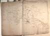
A survey of part of the lands of Coolcashen [Coolcashin] in the barony of Galmoy and County of Kilkenny the estate of George Watters. 1813. Table of reference showing tenants names & acreage of holdings.
Map
Language:
English
Format:
Map
In collection:
Longfield Map Collection
Published / Created
[1813]
Notes
There is a large crease running through the centre of...
Contributors:
“
...
Longfield
,
Robert
Ormsby
,
1844
-
1908
,
donor
...
”
Call Number:
Loading...
Located:
Loading...
A map of holdings in Little Ship Street. Names of tenants shown on holdings
Map
Language:
English
Format:
Map
In collection:
Longfield Map Collection
Published / Created
[between 1770 and 1840]
Notes
Physical description: 1 map Geographic Coverage: Dub...
Contributors:
“
...
Longfield
,
Robert
Ormsby
,
1844
-
1908
,
donor
...
”
Call Number:
Loading...
Located:
Loading...
1
Previous
5
6
7
8
9
10
11
12
13
14
15
Next
79
Get RSS Feed
Email this Search
History
Narrow Search
Digitised
Remove Filters
Clear Filter
Subject: Boundaries (Estates)
Format
1,578
Map
Online Availability
954
Digitised
624
Not Digitised
Published / Created
From:
To:
Subject
Boundaries (Estates)
1,578
Land tenure
1,578
Land use surveys
1,565
Administration of estates
268
History
48
Administration of Estates
Author
335
Longfield, John, ca. 1775-1833, surveyor
112
Brownrigg, John, ca. 1748-1838, surveyor
42
Brownrigg & Co., fl. 1801-1809, surveyors
38
Longfield, William, fl. 1825-ca. 1870, surveyor
8
Reading, Thomas, ca. 1704-1779, surveyor
7
Brownrigg, Longfield and Murray, fl. 1799-ca. 1805, surveyors
more ...
6
Gartland, William, fl. 1838-1851/68, surveyor
5
Byron, Samuel, fl. 1768-1795
4
Cave, Thomas, fl. ca. 1709-1749, surveyor
4
Scalé, Brownrigg & Sherrard, fl. 1774-1778, surveyors
3
Chaloner, Samuel, fl. 1812-1833, surveyor
3
Cuddehy, Michael, fl. 1791-1803, surveyor
3
Mathews, Thomas, fl. 1760-1784, surveyor
3
Roe, John, fl. 1793-1824, surveyor
3
Scully, Patrick, fl. 1777, surveyor
3
Sherrard, Thomas, ca. 1750-1837, surveyor
2
Brownrigg & Sherrard, fl. 1777-1778, surveyors
2
Byrne, John, fl. 1789-1828, surveyor
2
Donlevy, Bryan, fl. 1784-1792, surveyor
2
Frizell, Richard, fl. 1750-1797
2
Kirrilly, Bryan, fl. 1715-1716, surveyor
2
Lewis, Robert, fl. 1745-1785, surveyor
2
Lynch, Thomas, fl. 1804-1809, surveyor
2
Moynahan, John, fl. 1736-1764, surveyor
2
Mulvihill, Peter, ca. 1736-d. 1798, surveyor
2
Neville, Arthur Richards, fl. 1775-1828, surveyor
2
Sherrard & Brassington, fl. 1800-1822, surveyors
1
Balfe, M., fl. 1821, surveyor
1
Battersby, John, fl. 1778, surveyor
1
Bell, John (I and II), fl. 1721-1820
see all ...
less ...
Collections
1,578
Longfield Map Collection
Language
1,578
English
Genre
1,578
Manuscript maps
1,577
Maps, Manuscript
269
Early works to 1800
Era
268
18th century
1
19th century
Region
1,534
Ireland
711
Dublin (Ireland : County)
710
Dublin (County)
295
Dublin (Ireland)
293
Dublin
182
Kildare (County)
more ...
182
Kildare (Ireland : County)
155
Meath
155
Meath (Ireland)
118
Roscommon (County)
118
Roscommon (Ireland : County)
111
Rathdown (Barony)
85
Coolock (Barony)
76
Offaly West (Barony)
70
Uppercross (Barony)
47
Tipperary (County)
47
Tipperary (Ireland : County)
45
Northern Ireland
43
Newcastle (Barony)
40
Frenchpark (Barony)
40
Wicklow (County)
40
Wicklow (Ireland : County)
36
Castleknock (Barony)
35
Westmeath
35
Westmeath (Ireland)
34
Balrothery (Barony)
33
Laois
33
Laois (Ireland)
31
Dublin (Barony)
29
Nethercross (Barony)
see all ...
less ...
Loading...
![[A survey of] Part of the Lands of Glasnevin let by the Dean and Chapter of Christ Church to the Honble. Wm. John Gore. [By John Longfield]. Scale 16 Perches to an Inch](/IIIF/000310000/000301161/vtls000301161_001.jp2/full/100,/0/default.jpg)


![A survey of Venetian Park, in the Barony of Coolock and County of Dublin, the estate of [illegible] Vernon Esq. April 1831. Scale 10 Perches to an Inch](/IIIF/000310000/000301198/vtls000301198_001.jp2/full/100,/0/default.jpg)


![A survey of part of the lands of Coolcashen [Coolcashin] in the barony of Galmoy and County of Kilkenny the estate of George Watters. 1813. Table of reference showing tenants names & acreage of holdings.](/IIIF/000310000/000302137/vtls000302137_001.jp2/full/100,/0/default.jpg)