Showing
1 - 20
results of
33
for search '
Longfield, Robert Ormsby, 1844-1908, donor
'
Skip to content
Toggle navigation
NLI Website
- Catalogue -
English
Gaeilge
Home
Help
Advanced Search
Browse
Orders
Ask a Librarian
Language
English
Gaeilge
All Fields
Title
Author
Subject
Call Number
ISBN/ISSN
Publisher
Coordinates
Search digitised content only
FIND
Author
Longfield, Robert Ormsby, 1844-1908, donor
Results
Showing
1 - 20
results of
33
for search '
Longfield, Robert Ormsby, 1844-1908, donor
'
, query time: 0.04s
List
Grid
Sort
Relevance
Newest First
Oldest First
Call Number
Author
Title
1
2
Next
2
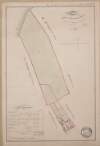
A map of several lots of ground in the town of Mountmellick part of the Marquis of Drogheda estate. Surveyed by John Longfield, 1819. Scale 4 perches to an inch. Table of reference showing tenants names & area of holdings.
Map
Main Creator:
Longfield, John, ca. 1775-1833, surveyor
Language:
English
Format:
Map
In collection:
Longfield Map Collection
Published / Created
[1819]
Notes
Physical description: 1 map Geographic Coverage: Bar...
Contributors:
“
...
Longfield
,
Robert
Ormsby
,
1844
-
1908
,
donor
...
”
Call Number:
Loading...
Located:
Loading...
A map of the Great Commons and of Little Commons adjoining the town of Portarlington in the Queens [Leix] County. Scale 20 perches to an inch.
Map
Language:
English
Format:
Map
In collection:
Longfield Map Collection
Published / Created
[between 1770 and 1840]
Notes
Some staining at the top of the map and a tear at the...
Contributors:
“
...
Longfield
,
Robert
Ormsby
,
1844
-
1908
,
donor
...
”
Call Number:
Loading...
Located:
Loading...
A survey of part of the lands of Shanahoe and Killeany in the barony of Maryborough West and Queen's [Leix] County purchased by H.H. Bawne Surveyed by J.L. 1815. Names of tenants & acreage of holdings shown.
Map
Main Creator:
Longfield, John, ca. 1775-1833, surveyor
Language:
English
Format:
Map
In collection:
Longfield Map Collection
Published / Created
[1815]
Notes
Physical description: 1 map Geographic Coverage: Cou...
Contributors:
“
...
Longfield
,
Robert
Ormsby
,
1844
-
1908
,
donor
...
”
Call Number:
Loading...
Located:
Loading...
A map of lands at Tinneel Mullaghanard and Avoley in the barony of Tinnahinch and Queens [Leix] County. Names of tenants and acreage of holdings shown.
Map
Language:
English
Format:
Map
In collection:
Longfield Map Collection
Published / Created
[between 1770 and 1840]
Notes
Physical description: 1 map Geographic Coverage: Bar...
Contributors:
“
...
Longfield
,
Robert
Ormsby
,
1844
-
1908
,
donor
...
”
Call Number:
Loading...
Located:
Loading...
A map of Woodfarm at Ballygeehin in the barony of Clarmallagh in Laois. Name of tenant & acreage of holding shown.
Map
Language:
English
Format:
Map
In collection:
Longfield Map Collection
Published / Created
[between 1770 and 1840]
Notes
Physical description: 1 map Geographic Coverage: Bar...
Contributors:
“
...
Longfield
,
Robert
Ormsby
,
1844
-
1908
,
donor
...
”
Call Number:
Loading...
Located:
Loading...
A map of lands at Clonbrock in the barony of Slievemargy and County Leix. Names of tenants & acreage of holdings shown.
Map
Language:
English
Format:
Map
In collection:
Longfield Map Collection
Published / Created
[between 1770 and 1840]
Notes
Physical description: 1 map Geographic Coverage: Bar...
Contributors:
“
...
Longfield
,
Robert
Ormsby
,
1844
-
1908
,
donor
...
”
Call Number:
Loading...
Located:
Loading...
A map showing part of the Townparks of Mountmellick in the barony of Tinnahinch and Queens [Leix] County. Names of tenants and acreage of holdings shown on table of reference & on map.
Map
Language:
English
Format:
Map
In collection:
Longfield Map Collection
Published / Created
[between 1770 and 1840]
Notes
Physical description: 1 map Geographic Coverage: Bar...
Contributors:
“
...
Longfield
,
Robert
Ormsby
,
1844
-
1908
,
donor
...
”
Call Number:
Loading...
Located:
Loading...
A survey of Ballycorman in the barony of Ballyadams and Queens County part of the estate of Gd. Fitzgerald let to Mr Tobias Purcell August 12th 1797. Scale 20 perches to an inch.
Map
Language:
English
Format:
Map
In collection:
Longfield Map Collection
Published / Created
[August 12 1797]
Notes
Physical description: 1 map Geographic Coverage: Bar...
Contributors:
“
...
Longfield
,
Robert
Ormsby
,
1844
-
1908
,
donor
...
”
Call Number:
Loading...
Located:
Loading...
A map of the demense of Ashfield in the barony of Portnahinch and Queens [Leix] County let by the Reverend Dean French to Capt. Archdall. Surveyed by J.L. March 1817. Scale 10 perches to an inch. Table of contents.
Map
Main Creator:
Longfield, John, ca. 1775-1833, surveyor
Language:
English
Format:
Map
In collection:
Longfield Map Collection
Published / Created
[March 1817]
Notes
Physical description: 1 map Geographic Coverage: Bar...
Contributors:
“
...
Longfield
,
Robert
Ormsby
,
1844
-
1908
,
donor
...
”
Call Number:
Loading...
Located:
Loading...
A map of Bellegrove and Rathronshin Queens [Leix] County.
Map
Language:
English
Format:
Map
In collection:
Longfield Map Collection
Published / Created
[between 1770 and 1840]
Notes
Physical description: 1 map Geographic Coverage: Bar...
Contributors:
“
...
Longfield
,
Robert
Ormsby
,
1844
-
1908
,
donor
...
”
Call Number:
Loading...
Located:
Loading...
A survey of lands at Garranmaconly and adjoining townlands in the barony of Clandonagh and County Leix. Scale 20 perches to an inch. Names of some tenants shown & acreage of holdings set out.
Map
Language:
English
Format:
Map
In collection:
Longfield Map Collection
Published / Created
[between 1770 and 1840]
Notes
Physical description: 1 map Geographic Coverage: Bar...
Contributors:
“
...
Longfield
,
Robert
Ormsby
,
1844
-
1908
,
donor
...
”
Call Number:
Loading...
Located:
Loading...
A map of lands at Cappalane and Derrylemoge in the barony of Tinnahinch and Queens [Leix] County. Scale 16 perches to an inch. Names of tenants and acreage of holdings shown.
Map
Language:
English
Format:
Map
In collection:
Longfield Map Collection
Published / Created
[between 1770 and 1840]
Notes
Physical description: 1 map Geographic Coverage: Bar...
Contributors:
“
...
Longfield
,
Robert
Ormsby
,
1844
-
1908
,
donor
...
”
Call Number:
Loading...
Located:
Loading...
A map of lands at Graigue and Moat in the barony of Cullenagh and Queens County [Leix] the estate of Gerald Fitzgerald. August 1797. Scale 20 perches to an inch. Adjoining proprietors shown.
Map
Language:
English
Format:
Map
In collection:
Longfield Map Collection
Published / Created
[August 1797]
Notes
Physical description: 1 map Geographic Coverage: Bar...
Contributors:
“
...
Longfield
,
Robert
Ormsby
,
1844
-
1908
,
donor
...
”
Call Number:
Loading...
Located:
Loading...
A map of the lands of Lismore, the estate of William Carden, and adjoining townlands in the parish of Aghaboe and barony of Clandonagh surveyed to ascertain the bounds of lands between the Duchens of Chandos and William Carden by John Longfield 1809.
Map
Main Creator:
Longfield, John, ca. 1775-1833, surveyor
Language:
English
Format:
Map
In collection:
Longfield Map Collection
Published / Created
[1809].
Notes
Physical description: 1 map Geographic Coverage: Par...
Contributors:
“
...
Longfield
,
Robert
Ormsby
,
1844
-
1908
,
donor
...
”
Call Number:
Loading...
Located:
Loading...
A plan showing sheets and properties in the town of Mountmellick in Queens [Leix] County. Names of tenants & acreage of holdings shown.
Map
Language:
English
Format:
Map
In collection:
Longfield Map Collection
Published / Created
[between 1770 and 1840]
Notes
In poor condition with stained, frayed edges and a la...
Contributors:
“
...
Longfield
,
Robert
Ormsby
,
1844
-
1908
,
donor
...
”
Call Number:
Loading...
Located:
Loading...
A map of Kilminchy in the barony of Maryborough East Queens County [Leix] for Gerald Fitzgerald. August 1797. Scale 20 perches to an inch. Names of adjoining owners shown.
Map
Language:
English
Format:
Map
In collection:
Longfield Map Collection
Published / Created
[August 1797]
Notes
Physical description: 1 map Geographic Coverage: Bar...
Contributors:
“
...
Longfield
,
Robert
Ormsby
,
1844
-
1908
,
donor
...
”
Call Number:
Loading...
Located:
Loading...
A map of lands at Ballyhuppahane in the barony of Tinnahinch and Queens [Leix] County. Names of tenants and acreage of holdings shown.
Map
Language:
English
Format:
Map
In collection:
Longfield Map Collection
Published / Created
[between 1770 and 1840]
Notes
Physical description: 1 map Geographic Coverage: Bar...
Contributors:
“
...
Longfield
,
Robert
Ormsby
,
1844
-
1908
,
donor
...
”
Call Number:
Loading...
Located:
Loading...
Map of lands at Coolcorberry, Stewartsgrove and Graceswood in the barony of Clarmallagh and County Leix. Scale 20 perches to an inch. Names of some tenants shown with acreage of holdings.
Map
Language:
English
Format:
Map
In collection:
Longfield Map Collection
Published / Created
[between 1770 and 1840]
Notes
Physical description: 1 map Geographic Coverage: Bar...
Contributors:
“
...
Longfield
,
Robert
Ormsby
,
1844
-
1908
,
donor
...
”
Call Number:
Loading...
Located:
Loading...
A map of part of ... Bellegrove and part of estate of the Reverend Dean French ... Surveyed January 26th 1813. By Edward Wall.
Map
Main Creator:
Wall, Edward, fl. 1795-1818, surveyor
Language:
English
Format:
Map
In collection:
Longfield Map Collection
Published / Created
[January 26 1813]
Notes
Some staining on the right-hand side of the map. Phys...
Contributors:
“
...
Longfield
,
Robert
Ormsby
,
1844
-
1908
,
donor
...
”
Call Number:
Loading...
Located:
Loading...
A map of lands at Cappalane Derrylemoge and Mullaghanard in the barony of Tinnahinch and Queens [Leix] County. Names of tenants and acreage of holdings shown.
Map
Language:
English
Format:
Map
In collection:
Longfield Map Collection
Published / Created
[between 1770 and 1840]
Notes
Physical description: 1 map Geographic Coverage: Bar...
Contributors:
“
...
Longfield
,
Robert
Ormsby
,
1844
-
1908
,
donor
...
”
Call Number:
Loading...
Located:
Loading...
1
2
Next
2
Get RSS Feed
Email this Search
History
Narrow Search
Digitised
Remove Filters
Clear Filter
Subject: Administration of estates
Clear Filter
Region: Laois (Ireland)
Format
33
Map
Online Availability
30
Digitised
3
Not Digitised
Published / Created
From:
To:
Subject
Administration of estates
33
Boundaries (Estates)
33
Land tenure
33
Land use surveys
5
History
Author
7
Longfield, John, ca. 1775-1833, surveyor
1
Brownrigg & Co., fl. 1801-1809, surveyors
1
Brownrigg, Longfield and Murray, fl. 1799-ca. 1805, surveyors
1
Frizell, Richard, fl. 1750-1797
1
Wall, Edward, fl. 1795-1818, surveyor
Collections
33
Longfield Map Collection
Language
33
English
Genre
33
Manuscript maps
33
Maps, Manuscript
5
Early works to 1800
Era
5
18th century
Region
33
Ireland
33
Laois
Laois (Ireland)
9
Portnahinch (Barony)
9
Tinnahinch (Barony)
4
Ballyadams (Barony)
more ...
3
Clarmallagh (Barony)
3
Slievemargy (Barony)
2
Clandonagh (Barony)
1
Aghaboe Parish
1
Aghahoe Parish (Ireland)
1
Cullenagh (Barony)
1
Maryborough East (Barony)
1
Rosenallis Parish
1
Rosenallis Parish (Ireland)
see all ...
less ...
Loading...
![A map of the Great Commons and of Little Commons adjoining the town of Portarlington in the Queens [Leix] County. Scale 20 perches to an inch.](/IIIF/000310000/000302381/vtls000302381_001.jp2/full/100,/0/default.jpg)
![A survey of part of the lands of Shanahoe and Killeany in the barony of Maryborough West and Queen's [Leix] County purchased by H.H. Bawne Surveyed by J.L. 1815. Names of tenants & acreage of holdings shown.](/IIIF/000310000/000302379/vtls000302379_001.jp2/full/100,/0/default.jpg)
![A map of lands at Tinneel Mullaghanard and Avoley in the barony of Tinnahinch and Queens [Leix] County. Names of tenants and acreage of holdings shown.](/IIIF/000310000/000302396/vtls000302396_001.jp2/full/100,/0/default.jpg)

![A map showing part of the Townparks of Mountmellick in the barony of Tinnahinch and Queens [Leix] County. Names of tenants and acreage of holdings shown on table of reference & on map.](/IIIF/000310000/000302401/vtls000302401_001.jp2/full/100,/0/default.jpg)

![A map of the demense of Ashfield in the barony of Portnahinch and Queens [Leix] County let by the Reverend Dean French to Capt. Archdall. Surveyed by J.L. March 1817. Scale 10 perches to an inch. Table of contents.](/IIIF/000310000/000302387/vtls000302387_001.jp2/full/100,/0/default.jpg)
![A map of Bellegrove and Rathronshin Queens [Leix] County.](/IIIF/000310000/000302389/vtls000302389_001.jp2/full/100,/0/default.jpg)

![A map of lands at Cappalane and Derrylemoge in the barony of Tinnahinch and Queens [Leix] County. Scale 16 perches to an inch. Names of tenants and acreage of holdings shown.](/IIIF/000310000/000302397/vtls000302397_001.jp2/full/100,/0/default.jpg)
![A map of lands at Graigue and Moat in the barony of Cullenagh and Queens County [Leix] the estate of Gerald Fitzgerald. August 1797. Scale 20 perches to an inch. Adjoining proprietors shown.](/IIIF/000310000/000302377/vtls000302377_001.jp2/full/100,/0/default.jpg)
![A plan showing sheets and properties in the town of Mountmellick in Queens [Leix] County. Names of tenants & acreage of holdings shown.](/IIIF/000310000/000302384/vtls000302384_001.jp2/full/100,/0/default.jpg)
![A map of Kilminchy in the barony of Maryborough East Queens County [Leix] for Gerald Fitzgerald. August 1797. Scale 20 perches to an inch. Names of adjoining owners shown.](/IIIF/000310000/000302378/vtls000302378_001.jp2/full/100,/0/default.jpg)
![A map of lands at Ballyhuppahane in the barony of Tinnahinch and Queens [Leix] County. Names of tenants and acreage of holdings shown.](/IIIF/000310000/000302400/vtls000302400_001.jp2/full/100,/0/default.jpg)

![A map of lands at Cappalane Derrylemoge and Mullaghanard in the barony of Tinnahinch and Queens [Leix] County. Names of tenants and acreage of holdings shown.](/IIIF/000310000/000302398/vtls000302398_001.jp2/full/100,/0/default.jpg)