Showing
1 - 20
results of
155
for search '
Longfield, Robert Ormsby, 1844-1908, donor
'
Skip to content
Toggle navigation
NLI Website
- Catalogue -
English
Gaeilge
Home
Help
Advanced Search
Browse
Orders
Ask a Librarian
Language
English
Gaeilge
All Fields
Title
Author
Subject
Call Number
ISBN/ISSN
Publisher
Coordinates
Search digitised content only
FIND
Author
Longfield, Robert Ormsby, 1844-1908, donor
Results
Showing
1 - 20
results of
155
for search '
Longfield, Robert Ormsby, 1844-1908, donor
'
, query time: 0.06s
List
Grid
Sort
Relevance
Newest First
Oldest First
Call Number
Author
Title
1
2
3
4
5
6
7
8
Next
8
A map of lands at Drewstown and Clonleasan in the barony of Upper Kells and County of Meath. Names of tenants & acreage of holdings shown.
Map
Language:
English
Format:
Map
In collection:
Longfield Map Collection
Published / Created
[between 1770 and 1840]
Notes
Physical description: 1 map Geographic Coverage: Bar...
Contributors:
“
...
Longfield
,
Robert
Ormsby
,
1844
-
1908
,
donor
...
”
Call Number:
Loading...
Located:
Loading...
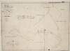
A map of the lands of Clare Mount [at Lisdornan] in the barony of Duleek Upper and County of Meath.
Map
Language:
English
Format:
Map
In collection:
Longfield Map Collection
Published / Created
[between 1770 and 1840]
Notes
Physical description: 1 map Geographic Coverage: Bar...
Contributors:
“
...
Longfield
,
Robert
Ormsby
,
1844
-
1908
,
donor
...
”
Call Number:
Loading...
Located:
Loading...
A survey of part of Stokestown in the barony of Dunboyne and County of Meath being part of the estate of the Most Honble. the Marquis of Lansdowne. Surveyed 14th & 15th August, 1829. Scale 20 statute perches to an inch. Tenants names shown. Table of reference with acreage.
Map
Language:
English
Format:
Map
In collection:
Longfield Map Collection
Published / Created
[August 14 1829]
Notes
Physical description: 1 map Geographic Coverage: Bar...
Contributors:
“
...
Longfield
,
Robert
Ormsby
,
1844
-
1908
,
donor
...
”
Call Number:
Loading...
Located:
Loading...
A map of part of Ballyboggan [situate near Kinnegad] in the County of Meath part of the estate of the Marquis of Lansdowne. By William Longfield May 1835. Scale 16 perches to an inch.
Map
Main Creator:
Longfield, William, fl. 1825-ca. 1870, surveyor
Language:
English
Format:
Map
In collection:
Longfield Map Collection
Published / Created
[May 1835]
Notes
Physical description: 1 map Geographic Coverage: Bar...
Contributors:
“
...
Longfield
,
Robert
Ormsby
,
1844
-
1908
,
donor
...
”
Call Number:
Loading...
Located:
Loading...
A map of the demense and lands of Williamstown in the barony of Kells Upper and County of Meath. Surveyed in May 1824 by John Roe. Scale 20 perches to an inch. On reverse - a letter from John Longfield, 18 January 1825, On the condition of the house & lands & their probable value.
Map
Main Creator:
Roe, John, fl. 1793-1824, surveyor
Language:
English
Format:
Map
In collection:
Longfield Map Collection
Published / Created
[May 1824]
Notes
Physical description: 1 map Geographic Coverage: Bar...
Contributors:
“
...
Longfield
,
Robert
Ormsby
,
1844
-
1908
,
donor
...
”
Call Number:
Loading...
Located:
Loading...
Longitudinal and transverse sections of that part of the river Blackwater adjoining the lands of Mullaghard Rathaldron and Liscartan in the County of Meath. Surveyed by John Long under the direction of William F. Mulvany C.E.
Map
Main Creator:
Longfield, John, ca. 1775-1833, surveyor
Language:
English
Format:
Map
In collection:
Longfield Map Collection
Published / Created
[between 1795 and 1833]
Notes
For other sections of the river Blackwater see: MS 2...
Contributors:
“
...
Longfield
,
Robert
Ormsby
,
1844
-
1908
,
donor
...
”
Call Number:
Loading...
Located:
Loading...
A map of part of Kildangan called Salusky in the barony of Moyfenrath Upper and County of Meath. Tenants names & area of holdings shown.
Map
Language:
English
Format:
Map
In collection:
Longfield Map Collection
Published / Created
[between 1770 and 1840]
Notes
Physical description: 1 map Geographic Coverage: Bar...
Contributors:
“
...
Longfield
,
Robert
Ormsby
,
1844
-
1908
,
donor
...
”
Call Number:
Loading...
Located:
Loading...
A map of Rossan Bogstown and Killaskillen Bogs in the barony of Moyfenrath Upper and County of Meath.
Map
Language:
English
Format:
Map
In collection:
Longfield Map Collection
Published / Created
[between 1770 and 1840]
Notes
Physical description: 1 map Geographic Coverage: Bar...
Contributors:
“
...
Longfield
,
Robert
Ormsby
,
1844
-
1908
,
donor
...
”
Call Number:
Loading...
Located:
Loading...
A map of lands at Proudstown in the barony of Skreen and County of Meath. Tenants names & acreage of lands shown.
Map
Language:
English
Format:
Map
In collection:
Longfield Map Collection
Published / Created
[between 1770 and 1840]
Notes
Physical description: 1 map Geographic Coverage: Bar...
Contributors:
“
...
Longfield
,
Robert
Ormsby
,
1844
-
1908
,
donor
...
”
Call Number:
Loading...
Located:
Loading...
Section of river Boyne.
Map
Language:
English
Format:
Map
In collection:
Longfield Map Collection
Published / Created
[between 1770 and 1840]
Notes
For other sections of the river Boyne see: MS 21 F. 1...
Contributors:
“
...
Longfield
,
Robert
Ormsby
,
1844
-
1908
,
donor
...
”
Call Number:
Loading...
Located:
Loading...
A map of Ardmulchon [Ardmulchan] in the barony of Skreen and County of Meath the estate of Wm. Pole May 1776 showing Mr. Eatons part, and Mr. Floods part of Ardmulchan in the possession of Mr. Taaf.
Map
Language:
English
Format:
Map
In collection:
Longfield Map Collection
Published / Created
[May 1776]
Notes
Physical description: 1 map Geographic Coverage: Bar...
Contributors:
“
...
Longfield
,
Robert
Ormsby
,
1844
-
1908
,
donor
...
”
Call Number:
Loading...
Located:
Loading...
A map of Little Ardrums in the parish of Rathcore and County of Meath ... being part of the estate of Hers. L. Rowly. By Patrick Scully October 1776.
Map
Main Creator:
Scully, Patrick, fl. 1777, surveyor
Language:
English
Format:
Map
In collection:
Longfield Map Collection
Published / Created
[October 1776]
Notes
Physical description: 1 map Geographic Coverage: Par...
Contributors:
“
...
Longfield
,
Robert
Ormsby
,
1844
-
1908
,
donor
...
”
Call Number:
Loading...
Located:
Loading...
Longitudinal and transverse sections of that part of the river Blackwater adjoining the lands of Mullaghard Rathaldron and Liscartan in the County of Meath. Surveyed by John Long under the direction of William F. Mulvany C.E.
Map
Main Creator:
Longfield, John, ca. 1775-1833, surveyor
Language:
English
Format:
Map
In collection:
Longfield Map Collection
Published / Created
[between 1795 and 1833]
Notes
For other sections of the river Blackwater see: MS 21...
Contributors:
“
...
Longfield
,
Robert
Ormsby
,
1844
-
1908
,
donor
...
”
Call Number:
Loading...
Located:
Loading...
A survey of the lands of Johnstown in the barony of Duleek Upper and County of Meath. By J.B. August 31 [17]96. Scale 20 perches to an inch. Names of tenants & acreage of holdings shown.
Map
Main Creator:
Brownrigg, John, ca. 1748-1838, surveyor
Language:
English
Format:
Map
In collection:
Longfield Map Collection
Published / Created
[August 31 1796]
Notes
Physical description: 1 map Geographic Coverage: Bar...
Contributors:
“
...
Longfield
,
Robert
Ormsby
,
1844
-
1908
,
donor
...
”
Call Number:
Loading...
Located:
Loading...
A survey of the lands of Bedlowstown [Bellewstown] in the lower barony of Navan and County of Meath part of the estate of Nathanill Preston. Surveyed April 1813. By John Longfield. Names of tenants and acreage of holdings shown.
Map
Main Creator:
Longfield, John, ca. 1775-1833, surveyor
Language:
English
Format:
Map
In collection:
Longfield Map Collection
Published / Created
[April 1813]
Notes
Physical description: 1 map Geographic Coverage: Bar...
Contributors:
“
...
Longfield
,
Robert
Ormsby
,
1844
-
1908
,
donor
...
”
Call Number:
Loading...
Located:
Loading...
A map of Trubley in the barony of Deece Lower and County of Meath. Names of tenants & acreage of holdings shown.
Map
Language:
English
Format:
Map
In collection:
Longfield Map Collection
Published / Created
[between 1770 and 1840]
Notes
Physical description: 1 map Geographic Coverage: Bar...
Contributors:
“
...
Longfield
,
Robert
Ormsby
,
1844
-
1908
,
donor
...
”
Call Number:
Loading...
Located:
Loading...
A map of an estate at [Dangan?] in the barony of Moyfenrath Lower and County of Meath.
Map
Language:
English
Format:
Map
In collection:
Longfield Map Collection
Published / Created
[between 1770 and 1840]
Notes
There is a large tear running through the centre of t...
Contributors:
“
...
Longfield
,
Robert
Ormsby
,
1844
-
1908
,
donor
...
”
Call Number:
Loading...
Located:
Loading...
A map of Stokestown in the County of Meath ... Surveyed by Thomas Lynch. 1808. Scale 20 perches to an inch. Wards holdings shown.
Map
Main Creator:
Lynch, Thomas, fl. 1804-1809, surveyor
Language:
English
Format:
Map
In collection:
Longfield Map Collection
Published / Created
[1808]
Notes
Physical description: 1 map Geographic Coverage: Bar...
Contributors:
“
...
Longfield
,
Robert
Ormsby
,
1844
-
1908
,
donor
...
”
Call Number:
Loading...
Located:
Loading...
A map of part of the lands of Sterling [Stirling?] in the barony of Dunboyne and County Meath and part of the lands of Pheblestown [Phibblestown] in the barony of Castleknock and County Dublin. Surveyed for Mr. Bingham by J. Longfield 1806. Scale 10 perches to an inch.
Map
Main Creator:
Longfield, John, ca. 1775-1833, surveyor
Language:
English
Format:
Map
In collection:
Longfield Map Collection
Published / Created
[1806]
Notes
Physical description: 1 map Geographic Coverage: Bar...
Contributors:
“
...
Longfield
,
Robert
Ormsby
,
1844
-
1908
,
donor
...
”
Call Number:
Loading...
Located:
Loading...
A map of part of the lands at Gormanston in the barony of Duleek Upper and County of Meath. By W.L. 1844.
Map
Main Creator:
Longfield, William, fl. 1825-ca. 1870, surveyor
Language:
English
Format:
Map
In collection:
Longfield Map Collection
Published / Created
[1844]
Notes
Physical description: 1 map Geographic Coverage: Bar...
Contributors:
“
...
Longfield
,
Robert
Ormsby
,
1844
-
1908
,
donor
...
”
Call Number:
Loading...
Located:
Loading...
1
2
3
4
5
6
7
8
Next
8
Get RSS Feed
Email this Search
History
Narrow Search
Digitised
Remove Filters
Clear Filter
Collections: Longfield Map Collection
Clear Filter
Region: Meath
Format
155
Map
Online Availability
147
Digitised
8
Not Digitised
Published / Created
From:
To:
Subject
155
Boundaries (Estates)
155
Land tenure
155
Land use surveys
143
Administration of estates
33
Administration of Estates
23
History
Author
43
Longfield, John, ca. 1775-1833, surveyor
7
Brownrigg, John, ca. 1748-1838, surveyor
5
Longfield, William, fl. 1825-ca. 1870, surveyor
4
Brownrigg & Co., fl. 1801-1809, surveyors
3
Scully, Patrick, fl. 1777, surveyor
2
Byron, Samuel, fl. 1768-1795
more ...
2
Lynch, Thomas, fl. 1804-1809, surveyor
2
Scalé, Brownrigg & Sherrard, fl. 1774-1778, surveyors
1
Browne, John, fl. 1788-ca. 1807, surveyor
1
Gartland, William, fl. 1838-1851/68, surveyor
1
McCann, James, fl. 1800-1802, surveyor
1
Read, Andrew, fl. 1810, surveyor
1
Roe, John, fl. 1793-1824, surveyor
1
Vaughan, James, fl. 1795-1826
see all ...
less ...
Collections
Longfield Map Collection
Language
155
English
Genre
155
Manuscript maps
155
Maps, Manuscript
24
Early works to 1800
Era
23
18th century
Region
155
Ireland
Meath
155
Meath (Ireland)
20
Moyfenrath Upper (Barony)
19
Duleek Upper (Barony)
17
Skreen (Barony)
more ...
14
Kells Upper (Barony)
14
Moyfenrath Lower (Barony)
11
Morgallion (Barony)
11
Ratoath (Barony)
9
Dunboyne (Barony)
6
Fore (Barony)
5
Deece Upper (Barony)
4
Dublin (County)
4
Dublin (Ireland : County)
4
Kells Lower (Barony)
3
Navan Lower (Barony)
3
Rathcore Parish
3
Rathcore Parish (Ireland)
2
Deece Lower (Barony)
2
Duleek Lower (Barony)
2
Lune (Barony)
2
Upper Duleek (Barony)
1
Ardcath Parish
1
Ardcath Parish (Ireland)
1
Boyne River (Ireland)
1
Castleknock (Barony)
1
Coolock (Barony)
1
Dublin (Ireland)
1
Dublin City (Barony)
see all ...
less ...
Loading...

![A map of the lands of Clare Mount [at Lisdornan] in the barony of Duleek Upper and County of Meath.](/IIIF/000310000/000301746/vtls000301746_001.jp2/full/100,/0/default.jpg)

![A map of part of Ballyboggan [situate near Kinnegad] in the County of Meath part of the estate of the Marquis of Lansdowne. By William Longfield May 1835. Scale 16 perches to an inch.](/IIIF/000310000/000301806/vtls000301806_001.jp2/full/100,/0/default.jpg)


![A map of Ardmulchon [Ardmulchan] in the barony of Skreen and County of Meath the estate of Wm. Pole May 1776 showing Mr. Eatons part, and Mr. Floods part of Ardmulchan in the possession of Mr. Taaf.](/IIIF/000310000/000301861/vtls000301861_001.jp2/full/100,/0/default.jpg)


![A survey of the lands of Johnstown in the barony of Duleek Upper and County of Meath. By J.B. August 31 [17]96. Scale 20 perches to an inch. Names of tenants & acreage of holdings shown.](/IIIF/000310000/000301736/vtls000301736_001.jp2/full/100,/0/default.jpg)
![A survey of the lands of Bedlowstown [Bellewstown] in the lower barony of Navan and County of Meath part of the estate of Nathanill Preston. Surveyed April 1813. By John Longfield. Names of tenants and acreage of holdings shown.](/IIIF/000310000/000301841/vtls000301841_001.jp2/full/100,/0/default.jpg)

![A map of an estate at [Dangan?] in the barony of Moyfenrath Lower and County of Meath.](/IIIF/000310000/000301825/vtls000301825_001.jp2/full/100,/0/default.jpg)
![A map of part of the lands of Sterling [Stirling?] in the barony of Dunboyne and County Meath and part of the lands of Pheblestown [Phibblestown] in the barony of Castleknock and County Dublin. Surveyed for Mr. Bingham by J. Longfield 1806. Scale 10 perches to an inch.](/IIIF/000310000/000301758/vtls000301758_001.jp2/full/100,/0/default.jpg)
