Showing
1 - 15
results of
15
for search '
R. T.
'
Skip to content
Toggle navigation
NLI Website
- Catalogue -
English
Gaeilge
Home
Help
Advanced Search
Browse
Orders
Ask a Librarian
Language
English
Gaeilge
All Fields
Title
Author
Subject
Call Number
ISBN/ISSN
Publisher
Coordinates
Search digitised content only
FIND
Author
R. T.
Results
Showing
1 - 15
results of
15
for search '
R. T.
'
, query time: 0.08s
List
Grid
Sort
Relevance
Newest First
Oldest First
Call Number
Author
Title
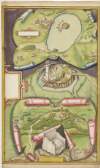
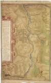
Map and description of Blackwater Valley, showing fortified positions of Irish and English in the O'Neill wars,
circa 1602.
Manuscript
Main Creator:
Bartlett, Richard, d. 1603
Language:
English
Format:
Manuscript
In collection:
Maps, drawings and plans by Richard Bartlett (Barthelet) and others, 1587-1625.
Published / Created
circa 1602.
Notes
Scale is marked "scala 500 passuum geometrical". Phys...
Call Number:
Loading...
Located:
Loading...
View Context
Plan of Mount Norris fort, Co. Armagh, with drawings of cabins,
circa 1602.
Manuscript
Main Creator:
Bartlett, Richard, d. 1603
Language:
English
Format:
Manuscript
In collection:
Maps, drawings and plans by Richard Bartlett (Barthelet) and others, 1587-1625.
Published / Created
circa 1602.
Notes
Scale is marked as "scala passuum comnius". Physical...
Call Number:
Loading...
Located:
Loading...
View Context
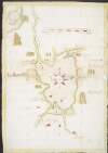
Map of forts in the Lough Neagh area, and showing forts fortified by Tyrone,
circa 1602.
Manuscript
Main Creator:
Bartlett, Richard, d. 1603
Language:
English
Format:
Manuscript
In collection:
Maps, drawings and plans by Richard Bartlett (Barthelet) and others, 1587-1625.
Published / Created
circa 1602.
Notes
Scale is given of "20 myles". Physical description:...
Call Number:
Loading...
Located:
Loading...
View Context
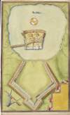
Plan of Mountjoy Fort, Lough Sydneye,
circa 1602.
Manuscript
Main Creator:
Bartlett, Richard, d. 1603
Language:
English
Format:
Manuscript
In collection:
Maps, drawings and plans by Richard Bartlett (Barthelet) and others, 1587-1625.
Published / Created
c. 1960 reproduction after original map
Notes
Scale is marked as "the scale of 20 yeardes 3 feet to...
Call Number:
Loading...
Located:
Loading...
View Context
Map of the district between Dundalk and Newry,
circa 1602.
Manuscript
Main Creator:
Bartlett, Richard, d. 1603
Language:
English
Format:
Manuscript
In collection:
Maps, drawings and plans by Richard Bartlett (Barthelet) and others, 1587-1625.
Published / Created
circa 1602.
Notes
Scale is marked as "Scala milliarium Hiber". Physical...
Call Number:
Loading...
Located:
Loading...
View Context
Autograph letter from Ricard [sic], Burke,
1679 June 8.
Manuscript
Main Creator:
Burke, Ricard
Language:
English
Format:
Manuscript
Published / Created
1679 June 8.
Notes
This letter is written on a small piece of paper (ca....
Call Number:
Loading...
Located:
Loading...
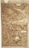
Drawing of Dungannon Castle and the stone chair at Tullaghoge, Co. Tyrone,
circa 1602.
Manuscript
Main Creator:
Bartlett, Richard, d. 1603
Language:
English
Format:
Manuscript
In collection:
Maps, drawings and plans by Richard Bartlett (Barthelet) and others, 1587-1625.
Published / Created
circa 1602.
Notes
No scale or annotations are provided on this plan. Ph...
Call Number:
Loading...
Located:
Loading...
View Context
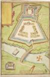
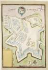
Plan of Charlemont Fort and bridge over the Blackwater river,
circa 1602.
Manuscript
Main Creator:
Bartlett, Richard, d. 1603
Language:
English
Format:
Manuscript
In collection:
Maps, drawings and plans by Richard Bartlett (Barthelet) and others, 1587-1625.
Published / Created
circa 1602.
Notes
Scale is marked as "yeardes and paces geom; th'one an...
Call Number:
Loading...
Located:
Loading...
View Context
Plan of Agher (Augher) Fort, Co. Tyrone,
circa 1602.
Manuscript
Main Creator:
Bartlett, Richard, d. 1603
Language:
English
Format:
Manuscript
In collection:
Maps, drawings and plans by Richard Bartlett (Barthelet) and others, 1587-1625.
Published / Created
circa 1602.
Notes
Scale to 40 yeardes is marked. Physical description:...
Call Number:
Loading...
Located:
Loading...
View Context
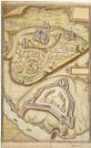
Plan of Armagh City and Mountjoy Fort on the Blackwater river,
circa 1602.
Manuscript
Main Creator:
Bartlett, Richard, d. 1603
Language:
English
Format:
Manuscript
In collection:
Maps, drawings and plans by Richard Bartlett (Barthelet) and others, 1587-1625.
Published / Created
circa 1602.
Notes
No scale is provided on this plan. Physical descripti...
Call Number:
Loading...
Located:
Loading...
View Context
Abstract of government expenditure addressed to Commissioners of Parliament of the Commonwealth of England for the Affairs of Ireland,
1654 May.
Manuscript
Language:
English
Format:
Manuscript
Published / Created
1654 May.
Notes
On vellum membrane, 81 x 67 cm. Physical description:...
Call Number:
Loading...
Located:
Loading...
Poictou :
1579.
Pictonum vicinarum que regionum fidiss descriptio. /
Manuscript
Main Creator:
Ortelius, Abraham, 1527-1598
Format:
Manuscript
In collection:
Theatrum orbis terrarum.
Published / Created
1592].
Notes
From the author's atlas 'Theatrum orbis terrarum', 15...
Call Number:
Loading...
Located:
Loading...
View Context
Palatinatus Bavariae descriptio :
Argentoratensis agri descriptio.
Manuscript
Main Creator:
Ortelius, Abraham, 1527-1598
Format:
Manuscript
In collection:
Theatrum orbis terrarum.
Published / Created
1584].
Notes
From the author's atlas 'Theatrum orbis terrarum', 15...
Call Number:
Loading...
Located:
Loading...
View Context
Buchaviae siue Fuldensis ditionis typus. :
1574 & 1575.
Waldeccensis comitatus descriptio accuratissima.,
Manuscript
Main Creator:
Ortelius, Abraham, 1527-1598
Format:
Manuscript
In collection:
Theatrum orbis terrarum.
Published / Created
1592].
Notes
Relief shown pictorially. From the author's atlas 'T...
Call Number:
Loading...
Located:
Loading...
View Context
Franciae orientalis (vulgo Franckenlant)descriptio. :
Monasteriensis et Osnburgensis episcopatus descriptio.
Manuscript
Main Creator:
Ortelius, Abraham, 1527-1598
Format:
Manuscript
In collection:
Theatrum orbis terrarum.
Published / Created
1592].
Notes
Relief shown pictorially. From the author's atlas 'T...
Call Number:
Loading...
Located:
Loading...
View Context
Get RSS Feed
Email this Search
History
Narrow Search
Clear Filter
Digitised
Remove Filters
Clear Filter
Format: Manuscript
Clear Filter
Genre: Early works to 1800
Format
Manuscript
Online Availability
Digitised
Published / Created
From:
To:
Subject
9
Maps, Manuscript
8
Forts & fortifications
4
Armagh (Northern Ireland : County)
3
History
3
Tyrone (Northern Ireland : County)
2
Politics and government
more ...
1
Bridges
1
Castles & palaces
1
Exile (Punishment)
1
History, Military
1
Louth (Ireland : County)
1
Maps and Surveys
1
Religious discrimination
1
Trials (Treason)
1
Tyrone's Rebellion, 1597-1603
see all ...
less ...
Author
9
Bartlett, Richard, d. 1603
4
Ortelius, Abraham, 1527-1598
1
Burke, Ricard
Collections
9
Maps, drawings and plans by Richard Bartlett (Barthelet) and others, 1587-1625.
4
Theatrum orbis terrarum.
Language
11
English
Genre
Early works to 1800
7
Maps, Manuscript
4
Maps
1
Correspondence
1
Sources
Era
3
17th century
1
1540?-1616
1
1595-1612
1
1649-1660
1
1660-1688
1
16th century
more ...
1
Charles II, 1660-1685
1
Civil War, 1642-1649
1
Commonwealth and Protectorate
see all ...
less ...
Region
9
Northern Ireland
4
Armagh (County)
4
Ireland
3
Tyrone (County)
2
Great Britain
1
Alsace (France)
more ...
1
Baden-Württemberg (Germany)
1
Bavaria (Germany)
1
Danube River
1
Franconia (Germany)
1
Fulda (Germany : Landkreis)
1
Ill River (France)
1
Louth (County)
1
Münsterland (Germany)
1
Osnabrücker Land (Germany)
1
Pays de la Loire (France)
1
Poitou-Charentes (France)
1
Tyrone
1
Waldeck-Frankenberg (Germany)
see all ...
less ...
Loading...

![Autograph letter from Ricard [sic], Burke,](/IIIF/000630000/000625659/vtls000625659_001.jp2/full/100,/0/default.jpg)