Showing
1 - 20
results of
268
for search '
Longfield, Robert Ormsby, 1844-1908, donor
'
Skip to content
Toggle navigation
NLI Website
- Catalogue -
English
Gaeilge
Home
Help
Advanced Search
Browse
Orders
Ask a Librarian
Language
English
Gaeilge
All Fields
Title
Author
Subject
Call Number
ISBN/ISSN
Publisher
Coordinates
Search digitised content only
FIND
Author
Longfield, Robert Ormsby, 1844-1908, donor
Results
Showing
1 - 20
results of
268
for search '
Longfield, Robert Ormsby, 1844-1908, donor
'
, query time: 0.04s
List
Grid
Sort
Relevance
Newest First
Oldest First
Call Number
Author
Title
1
2
3
4
5
6
7
8
9
10
11
Next
14
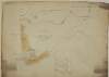
A survey of four holdings fronting Poolbeg Street Hawkins Street in the City of Dublin belonging to Wm. Frans. Read. By J. Brownrigg April 1790. Names of tenants shown on holdings
Map
Main Creator:
Brownrigg, John, ca. 1748-1838, surveyor
Language:
English
Format:
Map
In collection:
Longfield Map Collection
Published / Created
[April 1790]
Notes
Physical description: 1 map Geographic Coverage: Dub...
Contributors:
“
...
Longfield
,
Robert
Ormsby
,
1844
-
1908
,
donor
...
”
Call Number:
Loading...
Located:
Loading...
[Map of] Part of the Lands of Rathgar in the County of Dublin let by Mr. Val. Smith to Mr. Leonard Cornwall Dec 3rd 1795. Scale 10 Perches to an Inch
Map
Language:
English
Format:
Map
In collection:
Longfield Map Collection
Published / Created
[December 03 1795]
Notes
Physical description: 1 map Geographic Coverage: Bar...
Contributors:
“
...
Longfield
,
Robert
Ormsby
,
1844
-
1908
,
donor
...
”
Call Number:
Loading...
Located:
Loading...
A survey of Aughakine [Aghakine] in the parish of St. Cullom Kill [Columkille] barony of Granard & County of Longford the estate of Thomas Burrows. August 27 1790. Scale 20 perches to an inch. Names of tenants & acreage of holdings shown.
Map
Language:
English
Format:
Map
In collection:
Longfield Map Collection
Published / Created
[August 27 1790]
Notes
Physical description: 1 map Geographic Coverage: Par...
Contributors:
“
...
Longfield
,
Robert
Ormsby
,
1844
-
1908
,
donor
...
”
Call Number:
Loading...
Located:
Loading...
A map of Carrowreagh in the barony of Boyle and County of Roscommon as set by Arthur French. A scale of 40 perches to an inch. Surveyed in August 1792. By [illegible] Donleavy. Table of reference showing names of some tenants.
Map
Main Creator:
Donlevy, Bryan, fl. 1784-1792, surveyor
Language:
English
Format:
Map
In collection:
Longfield Map Collection
Published / Created
[August 1792]
Notes
Physical description: 1 map Geographic Coverage: Bar...
Contributors:
“
...
Longfield
,
Robert
Ormsby
,
1844
-
1908
,
donor
...
”
Call Number:
Loading...
Located:
Loading...
A survey of Curratantha [Corratanty] in the barony of Cremorne the estate of the Rt. Hon. Lord Templetown November 1797. Scale 20 perches to an inch. Names of tenants & acreage of holdings shown.
Map
Language:
English
Format:
Map
In collection:
Longfield Map Collection
Published / Created
[November 1797]
Notes
Physical description: 1 map Geographic Coverage: Bar...
Contributors:
“
...
Longfield
,
Robert
Ormsby
,
1844
-
1908
,
donor
...
”
Call Number:
Loading...
Located:
Loading...
A survey of the Estate of Simon Davenport Esq. in the Barony of Tullygarvey and County of Cavan, by J. B[rownrigg] 1791.
Map
Main Creator:
Brownrigg, John, ca. 1748-1838, surveyor
Language:
English
Format:
Map
In collection:
Longfield Map Collection
Published / Created
[1791]
Notes
Physical description: 1 map Geographic Coverage: Par...
Contributors:
“
...
Longfield
,
Robert
Ormsby
,
1844
-
1908
,
donor
...
”
Call Number:
Loading...
Located:
Loading...
A map of a Lott of Building ground in the Lordship of Mary's Abbey and County of Dublin belonging to Mr. William Crosby. Survey'd by J. Brownrigg March 1789
Map
Main Creator:
Brownrigg, John, ca. 1748-1838, surveyor
Language:
English
Format:
Map
In collection:
Longfield Map Collection
Published / Created
[March 1789]
Notes
Physical description: 1 map Geographic Coverage: Dub...
Contributors:
“
...
Longfield
,
Robert
Ormsby
,
1844
-
1908
,
donor
...
”
Call Number:
Loading...
Located:
Loading...
A map of a concern at the rere of the houses on the north side of Castle Street in the City of Dublin let by Wm. English to Mr. Watkins May 1800. Tenants names shown on properties
Map
Language:
English
Format:
Map
In collection:
Longfield Map Collection
Published / Created
[May 1800]
Notes
Physical description: 1 map Geographic Coverage: Dub...
Contributors:
“
...
Longfield
,
Robert
Ormsby
,
1844
-
1908
,
donor
...
”
Call Number:
Loading...
Located:
Loading...
Part of Westmanstown in the Barony of Castleknock & County of Dublin, the Estate of Captn. Vesey. 1786 [illegible]
Map
Language:
English
Format:
Map
In collection:
Longfield Map Collection
Published / Created
[1786-1796]
Notes
Inset maps: B - "A survey of part of Cooltrena in the...
Contributors:
“
...
Longfield
,
Robert
Ormsby
,
1844
-
1908
,
donor
...
”
Call Number:
Loading...
Located:
Loading...
A survey of Cloncrave in the barony of Farbill and County of Westmeath the estate of Thomas Darlington. By J.B. 1795. Scale 20 perches to an inch. Table of reference showing acreage and nature of land.
Map
Main Creator:
Brownrigg, John, ca. 1748-1838, surveyor
Language:
English
Format:
Map
In collection:
Longfield Map Collection
Published / Created
[1795]
Notes
Physical description: 1 map Geographic Coverage: Bar...
Contributors:
“
...
Longfield
,
Robert
Ormsby
,
1844
-
1908
,
donor
...
”
Call Number:
Loading...
Located:
Loading...
A map of three houses on the Bachelors Walk belonging to Mr Alder Armstrong June 26 1784
Map
Language:
English
Format:
Map
In collection:
Longfield Map Collection
Published / Created
[June 26 1784]
Notes
Physical description: 1 map Geographic Coverage: Dub...
Contributors:
“
...
Longfield
,
Robert
Ormsby
,
1844
-
1908
,
donor
...
”
Call Number:
Loading...
Located:
Loading...
Certified trace of a map of property in Channel Row c.1723. Thos. Moland. Scale of 5 Perches to an inch.
Map
Language:
English
Format:
Map
In collection:
Longfield Map Collection
Published / Created
[1723]
Notes
Physical description: 1 map Geographic Coverage: Dub...
Contributors:
“
...
Longfield
,
Robert
Ormsby
,
1844
-
1908
,
donor
...
”
Call Number:
Loading...
Located:
Loading...
A map of part of Killeigh [Killeagh] in the Island of Allen and County Kildare the estate of Thomas Smith 1790.
Map
Language:
English
Format:
Map
In collection:
Longfield Map Collection
Published / Created
[1790]
Notes
Physical description: 1 map Geographic Coverage: Bar...
Contributors:
“
...
Longfield
,
Robert
Ormsby
,
1844
-
1908
,
donor
...
”
Call Number:
Loading...
Located:
Loading...
A survey of a holding in Beggar Lane being part of the Townparks of Longford now in the possession of Connor Moran Petr. Berne & McCarney December 1796.
Map
Language:
English
Format:
Map
In collection:
Longfield Map Collection
Published / Created
[December 1796]
Notes
To view this inset, consult MS 21 F. 40 / (027). Phys...
Contributors:
“
...
Longfield
,
Robert
Ormsby
,
1844
-
1908
,
donor
...
”
Call Number:
Loading...
Located:
Loading...
A plan of streets leading to Carlisle Bridge. Copied by J. Brownrigg 1799.
Map
Main Creator:
Brownrigg, John, ca. 1748-1838, surveyor
Language:
English
Format:
Map
In collection:
Longfield Map Collection
Published / Created
[1799]
Notes
Physical description: 1 map Geographic Coverage: Dub...
Contributors:
“
...
Longfield
,
Robert
Ormsby
,
1844
-
1908
,
donor
...
”
Call Number:
Loading...
Located:
Loading...
A map of Mylarstown [Mylerstown] & Killiagh [Killeagh] in the Island of Allen and County of Kildare the estate of Thomas Smyth held by William Wyly, Joseph & Aaron Mickle. Surveyed February 1765 by John Nettervile. Scale 40 perches to an inch. Table of reference showing tenants & acreage of holdings.
Map
Main Creator:
Netterville, John, fl. 1747-1768, surveyor
Language:
English
Format:
Map
In collection:
Longfield Map Collection
Published / Created
[February 1765]
Notes
Physical description: 1 map Geographic Coverage: Bar...
Contributors:
“
...
Longfield
,
Robert
Ormsby
,
1844
-
1908
,
donor
...
”
Call Number:
Loading...
Located:
Loading...
A survey of part of the lands of Graig [Graigues] in the parish of Downings barony of Clane and County of Kildare belonging to Nicholas Browne. Surveyed in October 1785 by Robert Lewis for John Brownrigg. Scale 20 perches to an inch. Names of some tenants, with areas of holdings, shown.
Map
Main Creator:
Lewis, Robert, fl. 1745-1785, surveyor
Language:
English
Format:
Map
In collection:
Longfield Map Collection
Published / Created
[October 1785]
Notes
Physical description: 1 map Geographic Coverage: Par...
Contributors:
“
...
Longfield
,
Robert
Ormsby
,
1844
-
1908
,
donor
...
”
Call Number:
Loading...
Located:
Loading...
A survey of part of the Lands of Puckstown in the County of Dublin, let by Thos. Twig Esq. to [illegible] Hammell Esq. Surveyed by J.B. 18th May 1793. Scale 10 Perches to an Inch
Map
Main Creator:
Brownrigg, John, ca. 1748-1838, surveyor
Language:
English
Format:
Map
In collection:
Longfield Map Collection
Published / Created
[May 18 1793]
Notes
Physical description: 1 map Geographic Coverage: Bar...
Contributors:
“
...
Longfield
,
Robert
Ormsby
,
1844
-
1908
,
donor
...
”
Call Number:
Loading...
Located:
Loading...
A survey of Jordans Lands in several Divisions in the Town & Lands of Crumlin and County of Dublin done for Wm. Thomas Esq., Miss Sarah Cuthbert, Widow and the Reverend John Grave Clark. By John Brownrigg 1784. Scale Ten Perches to an Inch
Map
Main Creator:
Brownrigg, John, ca. 1748-1838, surveyor
Language:
English
Format:
Map
In collection:
Longfield Map Collection
Published / Created
[1784]
Notes
Physical description: 1 map Geographic Coverage: Bar...
Contributors:
“
...
Longfield
,
Robert
Ormsby
,
1844
-
1908
,
donor
...
”
Call Number:
Loading...
Located:
Loading...
Map of the Demense of Kinturk in the barony of Fore and County of Westmeath the seat of William Pollard. Surveyed in 1786 by J.B. Scale 10 perches to an inch.
Map
Main Creator:
Brownrigg, John, ca. 1748-1838, surveyor
Language:
English
Format:
Map
In collection:
Longfield Map Collection
Published / Created
[1786]
Notes
Physical description: 1 map Geographic Coverage: Bar...
Contributors:
“
...
Longfield
,
Robert
Ormsby
,
1844
-
1908
,
donor
...
”
Call Number:
Loading...
Located:
Loading...
1
2
3
4
5
6
7
8
9
10
11
Next
14
Get RSS Feed
Email this Search
History
Narrow Search
Digitised
Remove Filters
Clear Filter
Era: 18th century
Clear Filter
Subject: Administration of estates
Format
268
Map
Online Availability
142
Digitised
126
Not Digitised
Published / Created
From:
To:
Subject
Administration of estates
268
Boundaries (Estates)
268
History
268
Land tenure
268
Land use surveys
1
Administration of Estates
Author
108
Brownrigg, John, ca. 1748-1838, surveyor
7
Reading, Thomas, ca. 1704-1779, surveyor
5
Byron, Samuel, fl. 1768-1795
4
Cave, Thomas, fl. ca. 1709-1749, surveyor
4
Scalé, Brownrigg & Sherrard, fl. 1774-1778, surveyors
3
Mathews, Thomas, fl. 1760-1784, surveyor
more ...
3
Scully, Patrick, fl. 1777, surveyor
3
Sherrard, Thomas, ca. 1750-1837, surveyor
2
Brownrigg & Co., fl. 1801-1809, surveyors
2
Donlevy, Bryan, fl. 1784-1792, surveyor
2
Frizell, Richard, fl. 1750-1797
2
Kirrilly, Bryan, fl. 1715-1716, surveyor
2
Lewis, Robert, fl. 1745-1785, surveyor
2
Moynahan, John, fl. 1736-1764, surveyor
2
Mulvihill, Peter, ca. 1736-d. 1798, surveyor
1
Battersby, John, fl. 1778, surveyor
1
Bell, John (I and II), fl. 1721-1820
1
Bourke, Theobald, fl. 1721-1746, surveyor
1
Bridge, Timothy, fl. 1725-1732, surveyor
1
Browne, John, fl. 1788-ca. 1807, surveyor
1
Brownrigg & Sherrard, fl. 1777-1778, surveyors
1
Brownrigg, Longfield and Murray, fl. 1799-ca. 1805, surveyors
1
Byrne, John, fl. 1789-1828, surveyor
1
Campbell, James, fl. 1773-1783, surveyor
1
Cooley, Garret, fl. 1787, surveyor
1
Costello, James, fl. 1753-1787, surveyor
1
Cuddehy, Michael, fl. 1791-1803, surveyor
1
Cuttle, Thomas (I), fl. 1722-d. 1769
1
Downer, Maurice, fl. 1747-1778, surveyor
1
Evans, Richard, fl. 1789-1819, surveyor
see all ...
less ...
Collections
268
Longfield Map Collection
Language
268
English
Genre
268
Early works to 1800
268
Manuscript maps
268
Maps, Manuscript
Era
18th century
Region
264
Ireland
156
Dublin (Ireland : County)
155
Dublin (County)
64
Dublin (Ireland)
63
Dublin
25
Rathdown (Barony)
more ...
23
Meath
23
Meath (Ireland)
21
Kildare (County)
21
Kildare (Ireland : County)
20
Coolock (Barony)
18
Uppercross (Barony)
13
Dublin City (Barony)
11
Balrothery (Barony)
11
Westmeath
11
Westmeath (Ireland)
10
Roscommon (County)
10
Roscommon (Ireland : County)
9
Nethercross (Barony)
8
Dublin (Barony)
8
Longford (County)
8
Longford (Ireland : County)
8
Tipperary (County)
8
Tipperary (Ireland : County)
7
Frenchpark (Barony)
7
Skreen (Barony)
6
Connell (Barony)
6
Fore (Barony)
5
Deece Upper (Barony)
5
Eliogarty (Barony)
see all ...
less ...
Loading...
![A survey of Aughakine [Aghakine] in the parish of St. Cullom Kill [Columkille] barony of Granard & County of Longford the estate of Thomas Burrows. August 27 1790. Scale 20 perches to an inch. Names of tenants & acreage of holdings shown.](/IIIF/000310000/000302254/vtls000302254_001.jp2/full/100,/0/default.jpg)
![A map of Carrowreagh in the barony of Boyle and County of Roscommon as set by Arthur French. A scale of 40 perches to an inch. Surveyed in August 1792. By [illegible] Donleavy. Table of reference showing names of some tenants.](/IIIF/000310000/000302449/vtls000302449_001.jp2/full/100,/0/default.jpg)
![A survey of Curratantha [Corratanty] in the barony of Cremorne the estate of the Rt. Hon. Lord Templetown November 1797. Scale 20 perches to an inch. Names of tenants & acreage of holdings shown.](/IIIF/000310000/000302362/vtls000302362_001.jp2/full/100,/0/default.jpg)
![A survey of the Estate of Simon Davenport Esq. in the Barony of Tullygarvey and County of Cavan, by J. B[rownrigg] 1791.](/IIIF/000310000/000302209/vtls000302209_001.jp2/full/100,/0/default.jpg)
![Part of Westmanstown in the Barony of Castleknock & County of Dublin, the Estate of Captn. Vesey. 1786 [illegible]](/IIIF/000310000/000301112/vtls000301112_001.jp2/full/100,/0/default.jpg)
![A map of part of Killeigh [Killeagh] in the Island of Allen and County Kildare the estate of Thomas Smith 1790.](/IIIF/000310000/000302117/vtls000302117_001.jp2/full/100,/0/default.jpg)
![A map of Mylarstown [Mylerstown] & Killiagh [Killeagh] in the Island of Allen and County of Kildare the estate of Thomas Smyth held by William Wyly, Joseph & Aaron Mickle. Surveyed February 1765 by John Nettervile. Scale 40 perches to an inch. Table of reference showing tenants & acreage of holdings.](/IIIF/000310000/000302034/vtls000302034_001.jp2/full/100,/0/default.jpg)
![A survey of part of the lands of Graig [Graigues] in the parish of Downings barony of Clane and County of Kildare belonging to Nicholas Browne. Surveyed in October 1785 by Robert Lewis for John Brownrigg. Scale 20 perches to an inch. Names of some tenants, with areas of holdings, shown.](/IIIF/000310000/000301984/vtls000301984_001.jp2/full/100,/0/default.jpg)
![A survey of part of the Lands of Puckstown in the County of Dublin, let by Thos. Twig Esq. to [illegible] Hammell Esq. Surveyed by J.B. 18th May 1793. Scale 10 Perches to an Inch](/IIIF/000310000/000301180/vtls000301180_001.jp2/full/100,/0/default.jpg)
