Showing
121 - 140
results of
268
for search '
Longfield, Robert Ormsby, 1844-1908, donor
'
Skip to content
Toggle navigation
NLI Website
- Catalogue -
English
Gaeilge
Home
Help
Advanced Search
Browse
Orders
Ask a Librarian
Language
English
Gaeilge
All Fields
Title
Author
Subject
Call Number
ISBN/ISSN
Publisher
Coordinates
Search digitised content only
FIND
Author
Longfield, Robert Ormsby, 1844-1908, donor
Results
Showing
121 - 140
results of
268
for search '
Longfield, Robert Ormsby, 1844-1908, donor
'
, query time: 0.04s
List
Grid
Sort
Relevance
Newest First
Oldest First
Call Number
Author
Title
1
Previous
2
3
4
5
6
7
8
9
10
11
12
Next
14
Map of Leixlip demense in the barony of Salt North and County of Kildare. Surveyed, October 1793. Table of reference showing area of fields.
Map
Language:
English
Format:
Map
In collection:
Longfield Map Collection
Published / Created
[1793-1794]
Notes
Inset map: "Map of part of the Grange of Baldoyle Feb...
Contributors:
“
...
Longfield
,
Robert
Ormsby
,
1844
-
1908
,
donor
...
”
Call Number:
Loading...
Located:
Loading...
A survey of part of the Lands of Kinsaly called Sweets farm in the Barony of Coolock & County of Dublin, the Estate of Mrs. Sarah Tighe by John Brownrigg 1794. Scale 10 Perches to an Inch
Map
Main Creator:
Brownrigg, John, ca. 1748-1838, surveyor
Language:
English
Format:
Map
In collection:
Longfield Map Collection
Published / Created
[1794]
Notes
Physical description: 1 map Geographic Coverage: Bar...
Contributors:
“
...
Longfield
,
Robert
Ormsby
,
1844
-
1908
,
donor
...
”
Call Number:
Loading...
Located:
Loading...
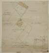
Copy of a map of several parcell's of Land - part of the Lands of Cottrellstown and Weystown. Barony of Balrothery in the County of Dublin, belonging to the Vicars and Prebends of Christ Church Dublin. Surveyed in June 1751. By Thos. Reading. [with copy of Indenture]
Map
Main Creator:
Reading, Thomas, ca. 1704-1779, surveyor
Language:
English
Format:
Map
In collection:
Longfield Map Collection
Published / Created
[June 1751]
Notes
Physical description: 1 map Geographic Coverage: Bar...
Contributors:
“
...
Longfield
,
Robert
Ormsby
,
1844
-
1908
,
donor
...
”
Call Number:
Loading...
Located:
Loading...
A survey of part of the Lands of High park in the parish of Clonturk, Barony of Coolock and County of Dublin March 9th 1790
Map
Language:
English
Format:
Map
In collection:
Longfield Map Collection
Published / Created
[March 09 1790]
Notes
Physical description: 1 map Geographic Coverage: Par...
Contributors:
“
...
Longfield
,
Robert
Ormsby
,
1844
-
1908
,
donor
...
”
Call Number:
Loading...
Located:
Loading...
[A map of holdings in the townlands of Ballisk, Turvery, etc, etc, in the Barony of Nethercross and County of Dublin - the Estate of Lady Dowager Kingsland 1774]
Map
Language:
English
Format:
Map
In collection:
Longfield Map Collection
Published / Created
[1774]
Notes
Physical description: 1 map Geographic Coverage: Bar...
Contributors:
“
...
Longfield
,
Robert
Ormsby
,
1844
-
1908
,
donor
...
”
Call Number:
Loading...
Located:
Loading...
A map of a holding on the east side of Charlemont Street belonging to Mr. Peter. Surveyed by J. Brownrigg 1795. Names of tenants shown on properties
Map
Main Creator:
Brownrigg, John, ca. 1748-1838, surveyor
Language:
English
Format:
Map
In collection:
Longfield Map Collection
Published / Created
[1795]
Notes
Physical description: 1 map Geographic Coverage: Dub...
Contributors:
“
...
Longfield
,
Robert
Ormsby
,
1844
-
1908
,
donor
...
”
Call Number:
Loading...
Located:
Loading...
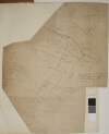
A map of Fyagh [Feagh] in the barony of Kells Lower and County of Meath, the estate of Thomas Bligh. Surveyed in September 1787 by J.B.
Map
Main Creator:
Brownrigg, John, ca. 1748-1838, surveyor
Language:
English
Format:
Map
In collection:
Longfield Map Collection
Published / Created
[1787-1788]
Notes
Inset map: "A map of a piece of ground on the west si...
Contributors:
“
...
Longfield
,
Robert
Ormsby
,
1844
-
1908
,
donor
...
”
Call Number:
Loading...
Located:
Loading...
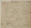
A map of Mr. Lawlers part of Kile [Kyleballynamoe] in the barony of Crannagh and County of Kilkenny. Surveyed 1794. By John O'Brien. Acreage of fields & crop distribution shown.
Map
Main Creator:
O'Brien, John, fl. 1784-1820, surveyor
Language:
English
Format:
Map
In collection:
Longfield Map Collection
Published / Created
[1794]
Notes
The map is in two pieces with a large tear running do...
Contributors:
“
...
Longfield
,
Robert
Ormsby
,
1844
-
1908
,
donor
...
”
Call Number:
Loading...
Located:
Loading...
A map of Kilminchy in the barony of Maryborough East Queens County [Leix] for Gerald Fitzgerald. August 1797. Scale 20 perches to an inch. Names of adjoining owners shown.
Map
Language:
English
Format:
Map
In collection:
Longfield Map Collection
Published / Created
[August 1797]
Notes
Physical description: 1 map Geographic Coverage: Bar...
Contributors:
“
...
Longfield
,
Robert
Ormsby
,
1844
-
1908
,
donor
...
”
Call Number:
Loading...
Located:
Loading...
A map of a holding on the west side of Fishamble Street in the City of Dublin belonging to the Dean & Chapter of Christ Church. March 1799. Names of adjoining tenants shown
Map
Language:
English
Format:
Map
In collection:
Longfield Map Collection
Published / Created
[March 1799]
Notes
Physical description: 1 map Geographic Coverage: Dub...
Contributors:
“
...
Longfield
,
Robert
Ormsby
,
1844
-
1908
,
donor
...
”
Call Number:
Loading...
Located:
Loading...
A map of part of the farm of St. Sepulchres in County of Dublin held under His Grace Robt. Lord Archbishop of Dublin by Wm. Thomas. Surveyed by John Brownrigg 1795. Scale 80 feet to an inch. Names of adjoining tenants shown
Map
Main Creator:
Brownrigg, John, ca. 1748-1838, surveyor
Language:
English
Format:
Map
In collection:
Longfield Map Collection
Published / Created
[1795]
Notes
Physical description: 1 map Geographic Coverage: Dub...
Contributors:
“
...
Longfield
,
Robert
Ormsby
,
1844
-
1908
,
donor
...
”
Call Number:
Loading...
Located:
Loading...
A survey of the lands of Johnstown in the barony of Duleek Upper and County of Meath. By J.B. August 31 [17]96. Scale 20 perches to an inch. Names of tenants & acreage of holdings shown.
Map
Main Creator:
Brownrigg, John, ca. 1748-1838, surveyor
Language:
English
Format:
Map
In collection:
Longfield Map Collection
Published / Created
[August 31 1796]
Notes
Physical description: 1 map Geographic Coverage: Bar...
Contributors:
“
...
Longfield
,
Robert
Ormsby
,
1844
-
1908
,
donor
...
”
Call Number:
Loading...
Located:
Loading...
A map of part of the lands of Maddenstown in the County of Kildare the estate of John Ormsby Vandeleur sett in the following denominations to the undernamed tenants ... Surveyed December 1787 by Garret Cooley? Scale 40 perches to an inch.
Map
Main Creator:
Cooley, Garret, fl. 1787, surveyor
Language:
English
Format:
Map
In collection:
Longfield Map Collection
Published / Created
[1787]
Notes
Physical description: 1 map Geographic Coverage: Bar...
Contributors:
“
...
Longfield
,
Robert
Ormsby
,
1844
-
1908
,
donor
...
”
Call Number:
Loading...
Located:
Loading...
A map of a concern at the rere of the houses on the north side of Castle Street in the City of Dublin let by Wm. English to Mr. Watkins May 1800. Tenants names shown on properties
Map
Language:
English
Format:
Map
In collection:
Longfield Map Collection
Published / Created
[May 1800]
Notes
Physical description: 1 map Geographic Coverage: Dub...
Contributors:
“
...
Longfield
,
Robert
Ormsby
,
1844
-
1908
,
donor
...
”
Call Number:
Loading...
Located:
Loading...
A survey of a concern at the rere of Patricks Market and Patricks Close, part of the estate of Wm. Rowley. Feb 12. 1797. Adjoining owners shown.
Map
Language:
English
Format:
Map
In collection:
Longfield Map Collection
Published / Created
[February 12 1797]
Notes
Physical description: 1 map Geographic Coverage: Dub...
Contributors:
“
...
Longfield
,
Robert
Ormsby
,
1844
-
1908
,
donor
...
”
Call Number:
Loading...
Located:
Loading...
A survey of Mylarstown [Mylerstown] in the Islands of Allen barony of Great Connell County of Kildare the estate of Thomas Hutchinson Smyth. By John Brownrigg 1794. Scale 20 perches to an inch. Table of reference, numbered allotments & descriptive details of land with acreage of land tenants names shown.
Map
Main Creator:
Brownrigg, John, ca. 1748-1838, surveyor
Language:
English
Format:
Map
In collection:
Longfield Map Collection
Published / Created
[1794]
Notes
Physical description: 1 map Geographic Coverage: Bar...
Contributors:
“
...
Longfield
,
Robert
Ormsby
,
1844
-
1908
,
donor
...
”
Call Number:
Loading...
Located:
Loading...
A map of lands at Fermoyle and Clorhaun in the barony of Clarmallagh and County Leix the estate of Gerald Fitzgerald August, 1797. Scale 20 perches to an inch. Names of adjoining tenants shown.
Map
Language:
English
Format:
Map
In collection:
Longfield Map Collection
Published / Created
[August 1797]
Notes
Physical description: 1 map Geographic Coverage: Bar...
Contributors:
“
...
Longfield
,
Robert
Ormsby
,
1844
-
1908
,
donor
...
”
Call Number:
Loading...
Located:
Loading...
A map of Leestown [Leastown] in the Parish of Wespalstown and County of Dublin, the Estate of the Rt. Hon. H. Langd. Rowley Esq. Surveyd. in June 1788 by Peter Evers. Scale 20 Perches to an Inch
Map
Main Creator:
Evers, Peter, fl. 1788, surveyor
Language:
English
Format:
Map
In collection:
Longfield Map Collection
Published / Created
[June 1788]
Notes
Physical description: 1 map Geographic Coverage: Par...
Contributors:
“
...
Longfield
,
Robert
Ormsby
,
1844
-
1908
,
donor
...
”
Call Number:
Loading...
Located:
Loading...
Part of Westmanstown in the Barony of Castleknock & County of Dublin, the Estate of Captn. Vesey. 1786 [illegible]
Map
Language:
English
Format:
Map
In collection:
Longfield Map Collection
Published / Created
[1786-1796]
Notes
Inset maps: B - "A survey of part of Cooltrena in the...
Contributors:
“
...
Longfield
,
Robert
Ormsby
,
1844
-
1908
,
donor
...
”
Call Number:
Loading...
Located:
Loading...
A map of Bay View & Mount Pleasant in the Barony of Coolock & County of Dublin belonging to Robt. Burton Esq. Surveyed by J. Brownrigg 1792. Scale 10 Perches to an Inch
Map
Main Creator:
Brownrigg, John, ca. 1748-1838, surveyor
Language:
English
Format:
Map
In collection:
Longfield Map Collection
Published / Created
[1792]
Notes
Physical description: 1 map Geographic Coverage: Bar...
Contributors:
“
...
Longfield
,
Robert
Ormsby
,
1844
-
1908
,
donor
...
”
Call Number:
Loading...
Located:
Loading...
1
Previous
2
3
4
5
6
7
8
9
10
11
12
Next
14
Get RSS Feed
Email this Search
History
Narrow Search
Digitised
Remove Filters
Clear Filter
Era: 18th century
Format
268
Map
Online Availability
142
Digitised
126
Not Digitised
Published / Created
From:
To:
Subject
268
Administration of estates
268
Boundaries (Estates)
268
History
268
Land tenure
268
Land use surveys
1
Administration of Estates
Author
108
Brownrigg, John, ca. 1748-1838, surveyor
7
Reading, Thomas, ca. 1704-1779, surveyor
5
Byron, Samuel, fl. 1768-1795
4
Cave, Thomas, fl. ca. 1709-1749, surveyor
4
Scalé, Brownrigg & Sherrard, fl. 1774-1778, surveyors
3
Mathews, Thomas, fl. 1760-1784, surveyor
more ...
3
Scully, Patrick, fl. 1777, surveyor
3
Sherrard, Thomas, ca. 1750-1837, surveyor
2
Brownrigg & Co., fl. 1801-1809, surveyors
2
Donlevy, Bryan, fl. 1784-1792, surveyor
2
Frizell, Richard, fl. 1750-1797
2
Kirrilly, Bryan, fl. 1715-1716, surveyor
2
Lewis, Robert, fl. 1745-1785, surveyor
2
Moynahan, John, fl. 1736-1764, surveyor
2
Mulvihill, Peter, ca. 1736-d. 1798, surveyor
1
Battersby, John, fl. 1778, surveyor
1
Bell, John (I and II), fl. 1721-1820
1
Bourke, Theobald, fl. 1721-1746, surveyor
1
Bridge, Timothy, fl. 1725-1732, surveyor
1
Browne, John, fl. 1788-ca. 1807, surveyor
1
Brownrigg & Sherrard, fl. 1777-1778, surveyors
1
Brownrigg, Longfield and Murray, fl. 1799-ca. 1805, surveyors
1
Byrne, John, fl. 1789-1828, surveyor
1
Campbell, James, fl. 1773-1783, surveyor
1
Cooley, Garret, fl. 1787, surveyor
1
Costello, James, fl. 1753-1787, surveyor
1
Cuddehy, Michael, fl. 1791-1803, surveyor
1
Cuttle, Thomas (I), fl. 1722-d. 1769
1
Downer, Maurice, fl. 1747-1778, surveyor
1
Evans, Richard, fl. 1789-1819, surveyor
see all ...
less ...
Collections
268
Longfield Map Collection
Language
268
English
Genre
268
Early works to 1800
268
Manuscript maps
268
Maps, Manuscript
Era
18th century
Region
264
Ireland
156
Dublin (Ireland : County)
155
Dublin (County)
64
Dublin (Ireland)
63
Dublin
25
Rathdown (Barony)
more ...
23
Meath
23
Meath (Ireland)
21
Kildare (County)
21
Kildare (Ireland : County)
20
Coolock (Barony)
18
Uppercross (Barony)
13
Dublin City (Barony)
11
Balrothery (Barony)
11
Westmeath
11
Westmeath (Ireland)
10
Roscommon (County)
10
Roscommon (Ireland : County)
9
Nethercross (Barony)
8
Dublin (Barony)
8
Longford (County)
8
Longford (Ireland : County)
8
Tipperary (County)
8
Tipperary (Ireland : County)
7
Frenchpark (Barony)
7
Skreen (Barony)
6
Connell (Barony)
6
Fore (Barony)
5
Deece Upper (Barony)
5
Eliogarty (Barony)
see all ...
less ...
Loading...

![Copy of a map of several parcell's of Land - part of the Lands of Cottrellstown and Weystown. Barony of Balrothery in the County of Dublin, belonging to the Vicars and Prebends of Christ Church Dublin. Surveyed in June 1751. By Thos. Reading. [with copy of Indenture]](/IIIF/000310000/000302265/vtls000302265_001.jp2/full/100,/0/default.jpg)
![A map of Fyagh [Feagh] in the barony of Kells Lower and County of Meath, the estate of Thomas Bligh. Surveyed in September 1787 by J.B.](/IIIF/000310000/000301785/vtls000301785_001.jp2/full/100,/0/default.jpg)
![A map of Mr. Lawlers part of Kile [Kyleballynamoe] in the barony of Crannagh and County of Kilkenny. Surveyed 1794. By John O'Brien. Acreage of fields & crop distribution shown.](/IIIF/000310000/000302130/vtls000302130_001.jp2/full/100,/0/default.jpg)
![A map of Kilminchy in the barony of Maryborough East Queens County [Leix] for Gerald Fitzgerald. August 1797. Scale 20 perches to an inch. Names of adjoining owners shown.](/IIIF/000310000/000302378/vtls000302378_001.jp2/full/100,/0/default.jpg)
![A survey of the lands of Johnstown in the barony of Duleek Upper and County of Meath. By J.B. August 31 [17]96. Scale 20 perches to an inch. Names of tenants & acreage of holdings shown.](/IIIF/000310000/000301736/vtls000301736_001.jp2/full/100,/0/default.jpg)

![A survey of Mylarstown [Mylerstown] in the Islands of Allen barony of Great Connell County of Kildare the estate of Thomas Hutchinson Smyth. By John Brownrigg 1794. Scale 20 perches to an inch. Table of reference, numbered allotments & descriptive details of land with acreage of land tenants names shown.](/IIIF/000310000/000301989/vtls000301989_001.jp2/full/100,/0/default.jpg)
![A map of Leestown [Leastown] in the Parish of Wespalstown and County of Dublin, the Estate of the Rt. Hon. H. Langd. Rowley Esq. Surveyd. in June 1788 by Peter Evers. Scale 20 Perches to an Inch](/IIIF/000310000/000301077/vtls000301077_001.jp2/full/100,/0/default.jpg)
![Part of Westmanstown in the Barony of Castleknock & County of Dublin, the Estate of Captn. Vesey. 1786 [illegible]](/IIIF/000310000/000301112/vtls000301112_001.jp2/full/100,/0/default.jpg)