Showing
1 - 20
results of
176
for search '
Longfield, Robert Ormsby, 1844-1908, donor
'
Skip to content
Toggle navigation
NLI Website
- Catalogue -
English
Gaeilge
Home
Help
Advanced Search
Browse
Orders
Ask a Librarian
Language
English
Gaeilge
All Fields
Title
Author
Subject
Call Number
ISBN/ISSN
Publisher
Coordinates
Search digitised content only
FIND
Author
Longfield, Robert Ormsby, 1844-1908, donor
Results
Showing
1 - 20
results of
176
for search '
Longfield, Robert Ormsby, 1844-1908, donor
'
, query time: 0.07s
List
Grid
Sort
Relevance
Newest First
Oldest First
Call Number
Author
Title
1
2
3
4
5
6
7
8
9
Next
9
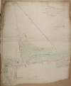
A survey of Borreen [Barreen] in the barony of Ikeathy & Ooughterany and County of Kildare the estate of Judge Johnson let to Mr. Thomas Frayne 1817. Scale 20 perches to an inch. Table of reference showing acreage of fields.
Map
Language:
English
Format:
Map
In collection:
Longfield Map Collection
Published / Created
[1817]
Notes
Physical description: 1 map Geographic Coverage: Bar...
Contributors:
“
...
Longfield
,
Robert
Ormsby
,
1844
-
1908
,
donor
...
”
Call Number:
Loading...
Located:
Loading...
A map of the lands of Carna [Carn] Barony of Offaly East and County of Kildare in the tenure of [Edward] Byrne. A survey of part of the lands of Carna [Carn] Barony of Offaly East Co Kildare in the tenure of Hugh Toole. Scale 16 perches to an inch. Table of reference tenants names & acreage of fields shown.
Map
Language:
English
Format:
Map
In collection:
Longfield Map Collection
Published / Created
[between 1770 and 1840]
Notes
Some staining around the edges with some old tape mar...
Contributors:
“
...
Longfield
,
Robert
Ormsby
,
1844
-
1908
,
donor
...
”
Call Number:
Loading...
Located:
Loading...
A map of the lands of Grangebeg in the Barony of Offaly West and County of Kildare. Names of tenants & acreage of holdings shown.
Map
Language:
English
Format:
Map
In collection:
Longfield Map Collection
Published / Created
[between 1770 and 1840]
Notes
Physical description: 1 map Geographic Coverage: Bar...
Contributors:
“
...
Longfield
,
Robert
Ormsby
,
1844
-
1908
,
donor
...
”
Call Number:
Loading...
Located:
Loading...
A map of lands at Gallows Hill and and Courtstown [Courttown] in the in the Barony of Narragh & Reban West in the County of Kildare. Scale 20 statute perches to an inch. Names of tenants & acreage of holdings shown.
Map
Language:
English
Format:
Map
In collection:
Longfield Map Collection
Published / Created
[between 1770 and 1840]
Notes
Physical description: 1 map Geographic Coverage: Bar...
Contributors:
“
...
Longfield
,
Robert
Ormsby
,
1844
-
1908
,
donor
...
”
Call Number:
Loading...
Located:
Loading...
A map of Cardington demense [Capt. Lefroy] in the Barony of Narragh & Reban West and County of Kildare. Names of tenants - Capt. Lefroy & William Maher - shown.
Map
Language:
English
Format:
Map
In collection:
Longfield Map Collection
Published / Created
[between 1770 and 1840]
Notes
Physical description: 1 map Geographic Coverage: Bar...
Contributors:
“
...
Longfield
,
Robert
Ormsby
,
1844
-
1908
,
donor
...
”
Call Number:
Loading...
Located:
Loading...
A survey of the town of Monasterevin done with a view to shew the advantage & improvement of changing the bridge from its present site so as to range with the main entrance from Dublin. By John Longfield, 1807. Scale 100 feet to an inch. Names of some tenants shown on properties.
Map
Main Creator:
Longfield, John, ca. 1775-1833, surveyor
Language:
English
Format:
Map
In collection:
Longfield Map Collection
Published / Created
[1807]
Notes
Physical description: 1 map Geographic Coverage: Bar...
Contributors:
“
...
Longfield
,
Robert
Ormsby
,
1844
-
1908
,
donor
...
”
Call Number:
Loading...
Located:
Loading...
A map of Derreens in the barony of Clane and County of Kildare the estate of Geo. Brien. Notes on turf banks, some names of tenants shown. Scale 20 perches to an inch. Darby Doogan's name on table of reference
Map
Language:
English
Format:
Map
In collection:
Longfield Map Collection
Published / Created
[between 1770 and 1840]
Notes
Physical description: 1 map Geographic Coverage: Bar...
Contributors:
“
...
Longfield
,
Robert
Ormsby
,
1844
-
1908
,
donor
...
”
Call Number:
Loading...
Located:
Loading...
A map of part of the bog of Monasterevin in the County of Kildare the estate of the most noble Charles, Marqis of Drogheda. By J.L. 1811. Names of tenants & acreage of turbary shown.
Map
Main Creator:
Longfield, John, ca. 1775-1833, surveyor
Language:
English
Format:
Map
In collection:
Longfield Map Collection
Published / Created
[1811]
Notes
Physical description: 1 map Geographic Coverage: Bar...
Contributors:
“
...
Longfield
,
Robert
Ormsby
,
1844
-
1908
,
donor
...
”
Call Number:
Loading...
Located:
Loading...
A map of Lullybeg and Lullymore in the Barony of Offaly East and County of Kildare
Map
Language:
English
Format:
Map
In collection:
Longfield Map Collection
Published / Created
[between 1770 and 1840]
Notes
Some staining around the edges of the map. Physical d...
Contributors:
“
...
Longfield
,
Robert
Ormsby
,
1844
-
1908
,
donor
...
”
Call Number:
Loading...
Located:
Loading...
A map of part of Killeigh [Killeagh] in the Island of Allen and County Kildare the estate of Thomas Smith 1790.
Map
Language:
English
Format:
Map
In collection:
Longfield Map Collection
Published / Created
[1790]
Notes
Physical description: 1 map Geographic Coverage: Bar...
Contributors:
“
...
Longfield
,
Robert
Ormsby
,
1844
-
1908
,
donor
...
”
Call Number:
Loading...
Located:
Loading...
A map of Mylarstown [Mylerstown] & Killiagh [Killeagh] in the Island of Allen and County of Kildare the estate of Thomas Smyth held by William Wyly, Joseph & Aaron Mickle. Surveyed February 1765 by John Nettervile. Scale 40 perches to an inch. Table of reference showing tenants & acreage of holdings.
Map
Main Creator:
Netterville, John, fl. 1747-1768, surveyor
Language:
English
Format:
Map
In collection:
Longfield Map Collection
Published / Created
[February 1765]
Notes
Physical description: 1 map Geographic Coverage: Bar...
Contributors:
“
...
Longfield
,
Robert
Ormsby
,
1844
-
1908
,
donor
...
”
Call Number:
Loading...
Located:
Loading...
A map of lands at Ardellis Lower in the Barony of Offaly West and County of Kildare. Scale 16 perches to an inch. Names of tenants acreage & nature of land shown.
Map
Language:
English
Format:
Map
In collection:
Longfield Map Collection
Published / Created
[between 1770 and 1840]
Notes
Physical description: 1 map Geographic Coverage: Bar...
Contributors:
“
...
Longfield
,
Robert
Ormsby
,
1844
-
1908
,
donor
...
”
Call Number:
Loading...
Located:
Loading...
A survey of part of the lands of Graig [Graigues] in the parish of Downings barony of Clane and County of Kildare belonging to Nicholas Browne. Surveyed in October 1785 by Robert Lewis for John Brownrigg. Scale 20 perches to an inch. Names of some tenants, with areas of holdings, shown.
Map
Main Creator:
Lewis, Robert, fl. 1745-1785, surveyor
Language:
English
Format:
Map
In collection:
Longfield Map Collection
Published / Created
[October 1785]
Notes
Physical description: 1 map Geographic Coverage: Par...
Contributors:
“
...
Longfield
,
Robert
Ormsby
,
1844
-
1908
,
donor
...
”
Call Number:
Loading...
Located:
Loading...
A map of the roads leading to Rathmore in the County of Kildare. Scale 40 perches to an inch. Names of bordering owners shown.
Map
Language:
English
Format:
Map
In collection:
Longfield Map Collection
Published / Created
[between 1770 and 1840]
Notes
Physical description: 1 map Geographic Coverage: Bar...
Contributors:
“
...
Longfield
,
Robert
Ormsby
,
1844
-
1908
,
donor
...
”
Call Number:
Loading...
Located:
Loading...
A map of part of Ballindooln, barony of Carberry [Carbury] and County Kildare the estate of Humphry Borr, 1804. Table of reference one tenants name shown
Map
Language:
English
Format:
Map
In collection:
Longfield Map Collection
Published / Created
[1804]
Notes
Physical description: 1 map Geographic Coverage: Bar...
Contributors:
“
...
Longfield
,
Robert
Ormsby
,
1844
-
1908
,
donor
...
”
Call Number:
Loading...
Located:
Loading...
Map of lands at Ballyvarney in the Barony of Offaly West and County of Kildare. Scale 20 statute perches to an inch. Name of tenant & acreage of fields shown.
Map
Language:
English
Format:
Map
In collection:
Longfield Map Collection
Published / Created
[between 1770 and 1840]
Notes
Physical description: 1 map Geographic Coverage: Bar...
Contributors:
“
...
Longfield
,
Robert
Ormsby
,
1844
-
1908
,
donor
...
”
Call Number:
Loading...
Located:
Loading...
A map of the lands of Cherryville in the Barony of Offaly West and County of Kildare. Surveyed in October 1839 by William Longfield. Also a table of reference between three methods of measurement.
Map
Main Creator:
Longfield, William, fl. 1825-ca. 1870, surveyor
Language:
English
Format:
Map
In collection:
Longfield Map Collection
Published / Created
[October 1839]
Notes
Physical description: 1 map Geographic Coverage: Bar...
Contributors:
“
...
Longfield
,
Robert
Ormsby
,
1844
-
1908
,
donor
...
”
Call Number:
Loading...
Located:
Loading...
A map of part of Cloney in the Barony of Narragh & Reban West and County of Kildare
Map
Language:
English
Format:
Map
In collection:
Longfield Map Collection
Published / Created
[between 1770 and 1840]
Notes
Physical description: 1 map Geographic Coverage: Bar...
Contributors:
“
...
Longfield
,
Robert
Ormsby
,
1844
-
1908
,
donor
...
”
Call Number:
Loading...
Located:
Loading...
Map of concerns in Monasterevin County Kildare. Scale 42 feet to an inch.
Map
Language:
English
Format:
Map
In collection:
Longfield Map Collection
Published / Created
[between 1770 and 1840]
Notes
Physical description: 1 map Geographic Coverage: Bar...
Contributors:
“
...
Longfield
,
Robert
Ormsby
,
1844
-
1908
,
donor
...
”
Call Number:
Loading...
Located:
Loading...
Map of lands at Cloneygath [Clonegath] in the Barony of Offaly West and County of Kildare. Names of tenants and acreage of holdings shown.
Map
Language:
English
Format:
Map
In collection:
Longfield Map Collection
Published / Created
[between 1770 and 1840]
Notes
Physical description: 1 map Geographic Coverage: Bar...
Contributors:
“
...
Longfield
,
Robert
Ormsby
,
1844
-
1908
,
donor
...
”
Call Number:
Loading...
Located:
Loading...
1
2
3
4
5
6
7
8
9
Next
9
Get RSS Feed
Email this Search
History
Narrow Search
Clear Filter
Digitised
Remove Filters
Clear Filter
Region: Kildare (Ireland : County)
Format
176
Map
Online Availability
Digitised
Published / Created
From:
To:
Subject
176
Administration of estates
176
Boundaries (Estates)
176
Land tenure
176
Land use surveys
21
History
Author
36
Longfield, John, ca. 1775-1833, surveyor
6
Brownrigg, John, ca. 1748-1838, surveyor
2
Gartland, William, fl. 1838-1851/68, surveyor
2
Longfield, William, fl. 1825-ca. 1870, surveyor
1
Bourke, Theobald, fl. 1721-1746, surveyor
1
Brownrigg & Co., fl. 1801-1809, surveyors
more ...
1
Byrne, John, fl. 1789-1828, surveyor
1
Byron, Samuel, fl. 1768-1795
1
Colbourne, Thomas, fl. 1810-1830
1
Cooley, Garret, fl. 1787, surveyor
1
Gibson, Robert, fl. 1731-1760, surveyor
1
Kennedy, Robert, fl. 1813, surveyor
1
Lewis, Robert, fl. 1745-1785, surveyor
1
Logan, John, fl. 1827-1846, surveyor
1
Netterville, John, fl. 1747-1768, surveyor
1
Reading, Thomas, ca. 1704-1779, surveyor
1
Spring, Francis, fl. 1707, surveyor
see all ...
less ...
Collections
176
Longfield Map Collection
Language
176
English
Genre
176
Manuscript maps
176
Maps, Manuscript
21
Early works to 1800
Era
21
18th century
Region
176
Ireland
176
Kildare (County)
Kildare (Ireland : County)
72
Offaly West (Barony)
16
Naas South (Barony)
12
Narragh and Reban East (Barony)
more ...
11
Naas North (Barony)
10
Clane (Barony)
9
Connell (Barony)
9
Kilcullen (Barony)
8
Salt North (Barony)
8
Salt South (Barony)
7
Offaly East (Barony)
6
Ikeathy and Oughterany (Barony)
5
Carbury (Barony)
5
Narragh and Reban West (Barony)
3
Kilkea and Moone (Barony)
2
Ballymore Eustace Parish
2
Ballymore Eustace Parish (Ireland)
2
Dublin (County)
2
Dublin (Ireland : County)
2
Kilcullen Parish
2
Kilcullen Parish (Ireland)
1
Balraheen Parish
1
Balraheen Parish (Ireland)
1
Coolock (Barony)
1
Dowings Parish
1
Dowings Parish (Ireland)
1
Dublin
1
Killcullen Parish
see all ...
less ...
Loading...
![A survey of Borreen [Barreen] in the barony of Ikeathy & Ooughterany and County of Kildare the estate of Judge Johnson let to Mr. Thomas Frayne 1817. Scale 20 perches to an inch. Table of reference showing acreage of fields.](/IIIF/000310000/000301998/vtls000301998_001.jp2/full/100,/0/default.jpg)
![A map of the lands of Carna [Carn] Barony of Offaly East and County of Kildare in the tenure of [Edward] Byrne. A survey of part of the lands of Carna [Carn] Barony of Offaly East Co Kildare in the tenure of Hugh Toole. Scale 16 perches to an inch. Table of reference tenants names & acreage of fields shown.](/IIIF/000310000/000302057/vtls000302057_001.jp2/full/100,/0/default.jpg)

![A map of lands at Gallows Hill and and Courtstown [Courttown] in the in the Barony of Narragh & Reban West in the County of Kildare. Scale 20 statute perches to an inch. Names of tenants & acreage of holdings shown.](/IIIF/000310000/000301996/vtls000301996_001.jp2/full/100,/0/default.jpg)
![A map of Cardington demense [Capt. Lefroy] in the Barony of Narragh & Reban West and County of Kildare. Names of tenants - Capt. Lefroy & William Maher - shown.](/IIIF/000310000/000302051/vtls000302051_001.jp2/full/100,/0/default.jpg)


![A map of part of Killeigh [Killeagh] in the Island of Allen and County Kildare the estate of Thomas Smith 1790.](/IIIF/000310000/000302117/vtls000302117_001.jp2/full/100,/0/default.jpg)
![A map of Mylarstown [Mylerstown] & Killiagh [Killeagh] in the Island of Allen and County of Kildare the estate of Thomas Smyth held by William Wyly, Joseph & Aaron Mickle. Surveyed February 1765 by John Nettervile. Scale 40 perches to an inch. Table of reference showing tenants & acreage of holdings.](/IIIF/000310000/000302034/vtls000302034_001.jp2/full/100,/0/default.jpg)

![A survey of part of the lands of Graig [Graigues] in the parish of Downings barony of Clane and County of Kildare belonging to Nicholas Browne. Surveyed in October 1785 by Robert Lewis for John Brownrigg. Scale 20 perches to an inch. Names of some tenants, with areas of holdings, shown.](/IIIF/000310000/000301984/vtls000301984_001.jp2/full/100,/0/default.jpg)

![A map of part of Ballindooln, barony of Carberry [Carbury] and County Kildare the estate of Humphry Borr, 1804. Table of reference one tenants name shown](/IIIF/000310000/000301968/vtls000301968_001.jp2/full/100,/0/default.jpg)


![Map of lands at Cloneygath [Clonegath] in the Barony of Offaly West and County of Kildare. Names of tenants and acreage of holdings shown.](/IIIF/000310000/000302205/vtls000302205_001.jp2/full/100,/0/default.jpg)