Showing
1 - 20
results of
343
for search '
Longfield, John, ca. 1775-1833, surveyor
'
Skip to content
Toggle navigation
NLI Website
- Catalogue -
English
Gaeilge
Home
Help
Advanced Search
Browse
Orders
Ask a Librarian
Language
English
Gaeilge
All Fields
Title
Author
Subject
Call Number
ISBN/ISSN
Publisher
Coordinates
Search digitised content only
FIND
Author
Longfield, John, ca. 1775-1833, surveyor
Results
Showing
1 - 20
results of
343
for search '
Longfield, John, ca. 1775-1833, surveyor
'
, query time: 0.04s
List
Grid
Sort
Relevance
Newest First
Oldest First
Call Number
Author
Title
1
2
3
4
5
6
7
8
9
10
11
Next
18
A map of part of the Lands of Swords call'd the Bullock Parks - let by the Revd. Sir James B Hutchinson to Mr. Pat Cuffe. Survey'd by J.L. 1814
Map
Main Creator:
Longfield
,
John
,
ca
.
1775
-
1833
,
surveyor
Language:
English
Format:
Map
In collection:
Longfield Map Collection
Published / Created
[1814]
Notes
Physical description: 1 map Geographic Coverage: Bar...
Call Number:
Loading...
Located:
Loading...
A map of the precincts of Christ Church showing the parts about to be purchased by the Commissioners of Wide Streets Surveyed by J.L. 1817.
Map
Main Creator:
Longfield
,
John
,
ca
.
1775
-
1833
,
surveyor
Language:
English
Format:
Map
In collection:
Longfield Map Collection
Published / Created
[1817]
Notes
Physical description: 1 map Geographic Coverage: Dub...
Call Number:
Loading...
Located:
Loading...
A survey of Part of Blanchardstown in the Barony of Castleknock and County of Dublin. The Estate of Peter Locke Esq. Let to Mr. Baird By J.L. 1829. Scale 20 Perches to an Inch
Map
Main Creator:
Longfield
,
John
,
ca
.
1775
-
1833
,
surveyor
Language:
English
Format:
Map
In collection:
Longfield Map Collection
Published / Created
[1829]
Notes
Physical description: 1 map Geographic Coverage: Bar...
Call Number:
Loading...
Located:
Loading...
A map of Rathcastle and Rowlandstown in the barony of Rathconrath and County Westmeath the estate of Thomas Bannon. Surveyed by J.L. 1809. Table of reference showing tenants and acreage of holdings. Scale 10 perches to an inch.
Map
Main Creator:
Longfield
,
John
,
ca
.
1775
-
1833
,
surveyor
Language:
English
Format:
Map
In collection:
Longfield Map Collection
Published / Created
[1809]
Notes
Physical description: 1 map Geographic Coverage: Bar...
Call Number:
Loading...
Located:
Loading...
A survey of Three lots of ground in the Town of Saggart in the County of Dublin, partly traced from Thomas Reading's Survey made in the year 1751 by John Longfield 1817
Map
Main Creator:
Longfield
,
John
,
ca
.
1775
-
1833
,
surveyor
Language:
English
Format:
Map
In collection:
Longfield Map Collection
Published / Created
[1817]
Notes
Physical description: 1 map Geographic Coverage: Bar...
Call Number:
Loading...
Located:
Loading...
A survey of three houses in Queen Street part of the estate of the Marquis of Lansdowne. Surveyed by John Longfield 1827. Names of tenants shown on properties.
Map
Main Creator:
Longfield
,
John
,
ca
.
1775
-
1833
,
surveyor
Language:
English
Format:
Map
In collection:
Longfield Map Collection
Published / Created
[1827]
Notes
Physical description: 1 map Geographic Coverage: Dub...
Call Number:
Loading...
Located:
Loading...
A map of part of the Lands of St. Dowlaghs in the County of Dublin, the Estate of the Chantor of Christ Church. Surveyed by Jn. Longfield 1815. Scale 20 Perches to an Inch
Map
Main Creator:
Longfield
,
John
,
ca
.
1775
-
1833
,
surveyor
Language:
English
Format:
Map
In collection:
Longfield Map Collection
Published / Created
[1815]
Notes
Physical description: 1 map Geographic Coverage: Bar...
Call Number:
Loading...
Located:
Loading...
A map of the manor of Clare in the County of Armagh & Kingdom of Ireland, the Estate of the Rt. Honourable John Earl of Sandwich & Peter De Sales Esq. Reduced from R. Brassingtons survey by Jn.. Longfield, 1805.
Map
Main Creator:
Longfield
,
John
,
ca
.
1775
-
1833
,
surveyor
Language:
English
Format:
Map
In collection:
Longfield Map Collection
Published / Created
[1805]
Notes
Physical description: 1 map Geographic Coverage: Par...
Call Number:
Loading...
Located:
Loading...
A plan of Naas gaol and the adjoining concerns. By J.L. 1824. Scale 20 feet to an inch.
Map
Main Creator:
Longfield
,
John
,
ca
.
1775
-
1833
,
surveyor
Language:
English
Format:
Map
In collection:
Longfield Map Collection
Published / Created
[1824]
Notes
Physical description: 1 map Geographic Coverage: Bar...
Call Number:
Loading...
Located:
Loading...
A map of the Lands of Drumnagally & Ballykiel near Banbridge in the County of Down the Estate of Nichs. Chl. White Esq. Surveyed by J.L. 1819.
Map
Main Creator:
Longfield
,
John
,
ca
.
1775
-
1833
,
surveyor
Language:
English
Format:
Map
In collection:
Longfield Map Collection
Published / Created
[1819]
Notes
Physical description: 1 map Geographic Coverage: Bar...
Call Number:
Loading...
Located:
Loading...
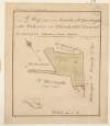
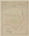
A map of part of the Lands of Palmerstown in the County of Dublin let by the Revd Sir B. Synge Hutchinson Bt. to [illegible]. Surveyed by J.L. 1816
Map
Main Creator:
Longfield
,
John
,
ca
.
1775
-
1833
,
surveyor
Language:
English
Format:
Map
In collection:
Longfield Map Collection
Published / Created
[1816]
Notes
Physical description: 1 map Geographic Coverage: Bar...
Call Number:
Loading...
Located:
Loading...
A map of the Glebe of Stillorgan alia Acrenakill, situate in the half Barony of Rathdown & County of Dublin, the Estate of the Dean of Christ Church, let to the representatives of the late Alderman Waver. Surveyed by J.L. June 1820. Scale 10 Perches to an Inch
Map
Main Creator:
Longfield
,
John
,
ca
.
1775
-
1833
,
surveyor
Language:
English
Format:
Map
In collection:
Longfield Map Collection
Published / Created
[June 1820]
Notes
Physical description: 1 map Geographic Coverage: Bar...
Call Number:
Loading...
Located:
Loading...
A survey of Lands of Mount Stuart in the Parish of Killossory, Barony of Coolock & County of Dublin, the Estate of Heny. Ellis Esq. by J.L. 1808. Scale 16 Perches to an Inch
Map
Main Creator:
Longfield
,
John
,
ca
.
1775
-
1833
,
surveyor
Language:
English
Format:
Map
In collection:
Longfield Map Collection
Published / Created
[1808]
Notes
Physical description: 1 map Geographic Coverage: Par...
Call Number:
Loading...
Located:
Loading...
A map of the holding No.17 Bridge Street in the City of Dublin, let by Mr. Michael Gernon to Mr John Anderson, Junr. Surveyed by John Longfield 1805. Names of adjoining tenants shown
Map
Main Creator:
Longfield
,
John
,
ca
.
1775
-
1833
,
surveyor
Language:
English
Format:
Map
In collection:
Longfield Map Collection
Published / Created
[1805]
Notes
Physical description: 1 map Geographic Coverage: Dub...
Call Number:
Loading...
Located:
Loading...
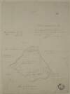
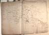
A survey of the lands of Mullanevally [Mullaghavally] in the barony of Lower Kells and County of Meath the estate of Thomas S. Whyte. By J. L. 1822. Scale 20 perches to an inch. Tenants names & acreage of holdings shown.
Map
Main Creator:
Longfield
,
John
,
ca
.
1775
-
1833
,
surveyor
Language:
English
Format:
Map
In collection:
Longfield Map Collection
Published / Created
[1822]
Notes
Physical description: 1 map Geographic Coverage: Bar...
Call Number:
Loading...
Located:
Loading...
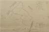
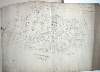
A map of part of the lands of Drummin [Drummond] in the barony of [Upper] Moyfenrath and County of Meath part of the estate of Lady Jane Loftus. Surveyed by J Longfield 1820. Names of tenants shown on holdings. Table of reference with tenants names acreage of holdings
Map
Main Creator:
Longfield
,
John
,
ca
.
1775
-
1833
,
surveyor
Language:
English
Format:
Map
In collection:
Longfield Map Collection
Published / Created
[1820]
Notes
Significant staining on the map. A large sticker from...
Call Number:
Loading...
Located:
Loading...
A map of part of the Lands of St. Dowlaghs call'd Bohomer with Church & Chh. ground, the estate of the Chantor of Christ Church. Survey'd by J. Longfield 1815. Scale 20 Perches to an Inch
Map
Main Creator:
Longfield
,
John
,
ca
.
1775
-
1833
,
surveyor
Language:
English
Format:
Map
In collection:
Longfield Map Collection
Published / Created
[1815]
Notes
Physical description: 1 map Geographic Coverage: Bar...
Call Number:
Loading...
Located:
Loading...
A map of Eight Lots of Building ground in Frederick Street and in the County of the City of Dublin. By J. Longfield 1816
Map
Main Creator:
Longfield
,
John
,
ca
.
1775
-
1833
,
surveyor
Language:
English
Format:
Map
In collection:
Longfield Map Collection
Published / Created
[1816]
Notes
Physical description: 1 map Geographic Coverage: Dub...
Call Number:
Loading...
Located:
Loading...
A map of several pieces of ground call'd the Castle Farm near Swords in the County of Dublin. Survey'd for Sr. Sl. Synge Hutchinson Esq by J. L. 1806. Scale 20 Perches to an Inch,
Map
Main Creator:
Longfield
,
John
,
ca
.
1775
-
1833
,
surveyor
Language:
English
Format:
Map
In collection:
Longfield Map Collection
Published / Created
[1806]
Notes
Physical description: 1 map Geographic Coverage: Bar...
Call Number:
Loading...
Located:
Loading...
A survey of part of the lands of Ballykean in the barony of Arklow and County of Wicklow the property of Joseph Stinger. By J.L. Feb 1827. Mr. Johnston shown as tenant of one portion.
Map
Main Creator:
Longfield
,
John
,
ca
.
1775
-
1833
,
surveyor
Language:
English
Format:
Map
In collection:
Longfield Map Collection
Published / Created
[February 1827]
Notes
Physical description: 1 map Geographic Coverage: Bar...
Call Number:
Loading...
Located:
Loading...
1
2
3
4
5
6
7
8
9
10
11
Next
18
Get RSS Feed
Email this Search
History
Narrow Search
Digitised
Format
343
Map
Online Availability
190
Digitised
153
Not Digitised
Published / Created
From:
To:
Subject
343
Boundaries (Estates)
343
Land tenure
343
Land use surveys
333
Administration of estates
19
Administration of Estates
2
History
Author
335
Longfield, John, ca. 1775-1833, surveyor
7
Brownrigg, Longfield and Murray, fl. 1799-ca. 1805, surveyors
1
Longfield, William, fl. 1825-ca. 1870, surveyor
Collections
343
Longfield Map Collection
Language
343
English
Genre
343
Manuscript maps
343
Maps, Manuscript
2
Early works to 1800
Era
2
18th century
Region
339
Ireland
191
Dublin (County)
191
Dublin (Ireland : County)
73
Dublin
73
Dublin (Ireland)
43
Meath
more ...
43
Meath (Ireland)
39
Kildare (County)
39
Kildare (Ireland : County)
33
Rathdown (Barony)
27
Coolock (Barony)
16
Offaly West (Barony)
14
Castleknock (Barony)
14
Uppercross (Barony)
13
Newcastle (Barony)
12
Nethercross (Barony)
11
Wicklow (County)
11
Wicklow (Ireland : County)
8
Duleek Upper (Barony)
8
Laois
8
Laois (Ireland)
8
Roscommon (County)
8
Roscommon (Ireland : County)
7
Moyfenrath Upper (Barony)
7
Ratoath (Barony)
6
Balrothery (Barony)
5
Dublin City (Barony)
5
Kilcullen (Barony)
5
Kilkenny (County)
5
Kilkenny (Ireland : County)
see all ...
less ...
Loading...

![A map of part of the Lands of Palmerstown in the County of Dublin let by the Revd Sir B. Synge Hutchinson Bt. to [illegible]. Surveyed by J.L. 1816](/IIIF/000310000/000302272/vtls000302272_001.jp2/full/100,/0/default.jpg)

![A survey of the lands of Mullanevally [Mullaghavally] in the barony of Lower Kells and County of Meath the estate of Thomas S. Whyte. By J. L. 1822. Scale 20 perches to an inch. Tenants names & acreage of holdings shown.](/IIIF/000310000/000301770/vtls000301770_001.jp2/full/100,/0/default.jpg)
![A map of part of the lands of Drummin [Drummond] in the barony of [Upper] Moyfenrath and County of Meath part of the estate of Lady Jane Loftus. Surveyed by J Longfield 1820. Names of tenants shown on holdings. Table of reference with tenants names acreage of holdings](/IIIF/000310000/000301970/vtls000301970_001.jp2/full/100,/0/default.jpg)