Showing
41 - 56
results of
56
for search '
Petty, William, Sir, 1623-1687
'
Skip to content
Toggle navigation
NLI Website
- Catalogue -
English
Gaeilge
Home
Help
Advanced Search
Browse
Orders
Ask a Librarian
Language
English
Gaeilge
All Fields
Title
Author
Subject
Call Number
ISBN/ISSN
Publisher
Coordinates
Search digitised content only
FIND
Author
Petty, William, Sir, 1623-1687
Results
Showing
41 - 56
results of
56
for search '
Petty, William, Sir, 1623-1687
'
, query time: 0.06s
List
Grid
Sort
Relevance
Newest First
Oldest First
Call Number
Author
Title
1
Previous
1
2
3
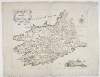
The Province of Munster,
[1685].
Map
Main Creator:
Petty
,
William
,
Sir
,
1623
-
1687
Language:
English
Format:
Map
Published / Created
[1685].
Notes
Originally bound in volume along with maps, surveys a...
Call Number:
Loading...
Located:
Loading...
View image
A geographical description of the kingdom of Ireland :
newly corrected & improv'd by actual observations. Containing one general map of the whole kingdom with 4 provincial and 32 county maps, ... The whole being laid down from the best maps vizt. Sr. Wm: Petty's, Mr. Pratt's, &c. with a description of each county collected from the best accounts extant.
Book
Main Creator:
Petty
,
William
,
Sir
,
1623
-
1687
.
Language:
English
Format:
Book
Published / Created
[1720]
Notes
The titlepage is engraved. First published in 1685 w...
Call Number:
Loading...
Located:
Loading...
The history of the survey of Ireland :
commonly called the Down survey, A.D. 1655-6 /
Book
Main Creator:
Petty
,
William
,
Sir
,
1623
-
1687
.
Language:
English
Format:
Book
Published / Created
1851.
Notes
Includes index. Physical description: 2 p. l., xxiii...
Call Number:
Loading...
Located:
Loading...
A geographicall description of ye kingdom of Ireland :
Collected from ye actual survey made by Sr. William Petty-Corrected & amended, by the advice, & assistance, of severall able artists, late inhabitants of that kingdom-Containing one generall mapp, of ye whole kingdom, with four provincial mapps, & 32. county mapps. divided into baronies, where in are discribed ye cheife cities, townes, rivers, harbors, and head-lands, &ca. To which is added a mapp of Great Brittaine and Ireland, together with an index of the whole. Being very usefull for all gentlemen, and military officers, as well for sea, as land service.
Book
Main Creator:
Petty
,
William
,
Sir
,
1623
-
1687
.
Language:
English
Format:
Book
Published / Created
[1689]
Notes
Entirely engraved. These are small maps printed in a...
Call Number:
Loading...
Located:
Loading...
Essays on mankind and political arithmetic.
Book
Main Creator:
Petty
,
William
,
Sir
,
1623
-
1687
.
Language:
English
Format:
Book
Published / Created
1888.
Notes
Physical description: 196 p. ; 16mo.
Call Number:
Loading...
Located:
Loading...
I.v. Maps,
c.1655-1867.
Map
Main Creator:
Petty
,
William
,
Sir
,
1623
-
1687
Language:
English
Format:
Map
In collection:
Holroyd-Smyth Family Papers, 1618-1965
Published / Created
1655-1867
Notes
These maps cannot be issued, in need of conservation....
Call Number:
Loading...
Located:
Loading...
View Context
Political arithmetick, or A discourse concerning, the extent and value of lands :
people, buildings; husbandry, manufacture, commerce, fishery, artizans, seamen, soldiers; publick revenues, interest, taxes, superlucration, registries, banks; valuation of men, increasing of seamen, of militia's, harbours, situation, shipping, power at sea, &c. As the same relates to every country in general, but more particularly to the territories of His Majesty of Great Britain, and his neighbours of Holland, Zealand, and France. By Sir William Petty, late Fellow of the Royal Society. /
Book
Main Creator:
Petty
,
William
,
Sir
,
1623
-
1687
.
Language:
English
Format:
Book
Published / Created
1691.
Notes
Dedication signed: Shelborne, i.e. Charles Petty, Bar...
Call Number:
Loading...
Located:
Loading...
The parish maps of the Down Survey for the county of Westmeath, attested by William Petty in 1659, copied by Daniel O'Brien,
1786-1787.
Manuscript
Main Creator:
O'Brien, Daniel, fl. 1786-1787
Language:
English
Format:
Manuscript
Published / Created
1786-1787.
Notes
Physical description: 2 items (2 vols., 67 maps).
Contributors:
“
...
Petty
,
William
,
Sir
,
1623
-
1687
...
”
Call Number:
Loading...
Located:
Loading...
A statistical account of the County of Roscommon by the Reverend John Keogh drawn up for Sir William Petty, Superintendant of the Down Survey, Anno Domini 1683. From the original manuscript T. C. D.
Manuscript
Main Creator:
Keogh, John, Reverend
Language:
English
Format:
Manuscript
Notes
With book plate pasted on verso of front cover belong...
Contributors:
“
...
Petty
,
William
,
Sir
,
1623
-
1687
...
”
Call Number:
Loading...
Located:
Loading...
The parish maps of the Down Survey for Queen's County [County Laois] and Kilkenny, attested by William Petty in 1657, copied by Daniel O'Brien,
1786.
Manuscript
Main Creator:
O'Brien, Daniel, fl. 1786-1787
Language:
English
Format:
Manuscript
Published / Created
1786.
Notes
Physical description: 1 item (1 map vol.).
Contributors:
“
...
Petty
,
William
,
Sir
,
1623
-
1687
...
”
Call Number:
Loading...
Located:
Loading...
The parish maps of the Down Survey for the county of Limerick, attested by William Petty in 1657, copied by Daniel O'Brien,
1786.
Manuscript
Main Creator:
O'Brien, Daniel, fl. 1786-1787
Language:
English
Format:
Manuscript
Published / Created
1786.
Notes
Physical description: 1 item (1 map vol.).
Contributors:
“
...
Petty
,
William
,
Sir
,
1623
-
1687
...
”
Call Number:
Loading...
Located:
Loading...
Observations on an unpublished essay on Ireland by Sir W. Petty (A.D. 1687).
Book
Main Creator:
Hardinge, William Henry, 1801-1879
Language:
English
Format:
Book
Published / Created
1866.
Notes
From the Transactions of the Royal Irish Academy, Vol...
Contributors:
“
...
Petty
,
William
,
Sir
,
1623
-
1687
...
”
Call Number:
Loading...
Located:
Loading...
The parish maps of the Down Survey for the county of Dublin, attested by William Petty in 1657, copied by Daniel O'Brien,
1786-1787.
Manuscript
Main Creator:
O'Brien, Daniel, fl. 1786-1787
Language:
English
Format:
Manuscript
Published / Created
1786-1787.
Notes
Physical description: 1 item (1 vol., 42 maps).
Contributors:
“
...
Petty
,
William
,
Sir
,
1623
-
1687
...
”
Call Number:
Loading...
Located:
Loading...
Collection of 17th century indentures,
1658-1694.
Manuscript
Language:
English
Format:
Manuscript
Published / Created
1658-1694.
Notes
On vellum, very fragile, handle with care. Physical d...
Contributors:
“
...
Petty
,
William
,
Sir
,
1623
-
1687
...
”
Call Number:
Loading...
Located:
Loading...
Phillips Maps.
Map
Main Creator:
Phillips, Thomas, 1635?-1693
Language:
English
Format:
Map
Published / Created
[1685].
Notes
MS 3137 was presented to the National Library by the...
Call Number:
Loading...
Located:
Loading...
A topographical index of the parishes and townlands of Ireland in Sir William Petty's Mss. barony maps (c. 1655-9) (Bibliothéque Nationale de Paris, Fonds Anglais, Nos. 1 & 2) and Hiberniae Delineatio (c. 1672) /
Book
Language:
English
Format:
Book
In collection:
Genealogical Office Library Collection
Notes
At head of title: Coimisiun Laimhscribhinni na hEirea...
Contributors:
“
...
Petty
,
William
,
Sir
,
1623
-
1687
....
”
Call Number:
Loading...
Located:
Loading...
1
Previous
1
2
3
Get RSS Feed
Email this Search
History
Narrow Search
Digitised
Format
34
Book
16
Map
6
Manuscript
Online Availability
44
Not Digitised
12
Digitised
Published / Created
From:
To:
Subject
12
Maps
12
Maps, Manuscript
7
Economics
6
Economic conditions
4
Maps and Surveys
4
Politics and government
more ...
4
Taxation
3
History
2
Finance
2
Vital statistics
1
Atlases
1
CHR 1899
1
Colonies
1
Description and travel
1
Early maps
1
Économie politique
1
Fortification
1
Irish
1
Land use
1
Mortality
1
Names, Geographical
1
Naval architecture
1
PRO Elias, Susan Homans (honoree)
1
PRO Vienken, Heinz J. (honoree)
1
Population
1
Population density
1
Population geography
1
Statistics
see all ...
less ...
Author
47
Petty, William, Sir, 1623-1687
4
O'Brien, Daniel, fl. 1786-1787
1
Hardinge, William Henry, 1801-1879
1
Keogh, John, Reverend
1
Phillips, Thomas, 1635?-1693
Collections
2
Phillips Maps.
1
Genealogical Office Library Collection
1
Holroyd-Smyth Family Papers, 1618-1965
Language
55
English
2
Latin
Genre
27
Early works to 1800
18
Maps
3
Statistics, Vital
2
Surveys
1
Controversial literature
1
Facsimiles
more ...
1
Statistics
see all ...
less ...
Era
6
17th century
4
1623-1687
1
1610-1688
1
1649-1775
1
To 1800
Region
29
Ireland
8
Great Britain
4
England
1
America
1
Clare (Ireland)
1
Cork (Ireland : County)
more ...
1
Corrib, Lough (Ireland)
1
Dublin (County)
1
Dublin (Ireland)
1
France
1
Galway (Ireland : County)
1
Kilkenny (County)
1
Laois (County)
1
Limerick (County)
1
London
1
London (England)
1
Maps and Surveys
1
Munster (Ireland)
1
Netherlands
1
Northern Ireland
1
Roscommon (Ireland : County)
1
Sligo (Ireland : County)
1
Ulster (Ireland)
1
Waterford (Ireland : County)
1
Westmeath (County)
1
Westmeath (Ireland)
see all ...
less ...
Loading...