Showing
1 - 20
results of
956
for search '
Longfield, Robert Ormsby, 1844-1908, donor
'
Skip to content
Toggle navigation
NLI Website
- Catalogue -
English
Gaeilge
Home
Help
Advanced Search
Browse
Orders
Ask a Librarian
Language
English
Gaeilge
All Fields
Title
Author
Subject
Call Number
ISBN/ISSN
Publisher
Coordinates
Search digitised content only
FIND
Author
Longfield, Robert Ormsby, 1844-1908, donor
Results
Showing
1 - 20
results of
956
for search '
Longfield, Robert Ormsby, 1844-1908, donor
'
, query time: 0.19s
List
Grid
Sort
Relevance
Newest First
Oldest First
Call Number
Author
Title
1
2
3
4
5
6
7
8
9
10
11
Next
48
A map of the glebe lands of Killenaule in the barony of Slievardagh and County of Tipperary belonging to the Chancellor of Christ Church. Surveyed and traced by J.L. 1817. Names of tenants shown & table of reference with tenants names & area of holdings. With additional list 4 January 1833 laid out and possession taken by Sheriff.
Map
Main Creator:
Longfield, John, ca. 1775-1833, surveyor
Language:
English
Format:
Map
In collection:
Longfield Map Collection
Published / Created
[1817]
Notes
Physical description: 1 map Geographic Coverage: Bar...
Contributors:
“
...
Longfield
,
Robert
Ormsby
,
1844
-
1908
,
donor
...
”
Call Number:
Loading...
Located:
Loading...
A map of Boxford and Cams in the County of Roscommon. March 1829. Scale 20 perches to an inch. Names of tenants and acreage of holdings shown.
Map
Language:
English
Format:
Map
In collection:
Longfield Map Collection
Published / Created
[March 1829]
Notes
Physical description: 1 map Geographic Coverage: Bar...
Contributors:
“
...
Longfield
,
Robert
Ormsby
,
1844
-
1908
,
donor
...
”
Call Number:
Loading...
Located:
Loading...
A map of Barbavilla demense in the barony of Fore and County of Westmeath. Names of tenants and acreage of holdings shown.
Map
Language:
English
Format:
Map
In collection:
Longfield Map Collection
Published / Created
[between 1770 and 1840]
Notes
Physical description: 1 map Geographic Coverage: Bar...
Contributors:
“
...
Longfield
,
Robert
Ormsby
,
1844
-
1908
,
donor
...
”
Call Number:
Loading...
Located:
Loading...
A map of part of the lands of Davidstown in the barony of Talbotstown Upper and County of Wicklow the estate of the Rev. Sir S.S. Hutchinson, Bart let to John Nowlan. Scale 20 perches to an inch.
Map
Language:
English
Format:
Map
In collection:
Longfield Map Collection
Published / Created
[between 1770 and 1840]
Notes
Physical description: 1 map Geographic Coverage: Bar...
Contributors:
“
...
Longfield
,
Robert
Ormsby
,
1844
-
1908
,
donor
...
”
Call Number:
Loading...
Located:
Loading...
A map of Rolagh part of the estate of Lord Gormanstown situate in the lower barony of Morgallion and County of Meath. Surveyed in January 1835 By W. Longfield. Scale 16 perches to an inch. Names of tenants & acreage of holdings shown.
Map
Main Creator:
Longfield, William, fl. 1825-ca. 1870, surveyor
Language:
English
Format:
Map
In collection:
Longfield Map Collection
Published / Created
[January 1835]
Notes
Physical description: 1 map Geographic Coverage: Bar...
Contributors:
“
...
Longfield
,
Robert
Ormsby
,
1844
-
1908
,
donor
...
”
Call Number:
Loading...
Located:
Loading...
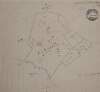
[A map of Coragleck County Fermanagh]. Names of proprietors & acres of holdings shown
Map
Language:
English
Format:
Map
In collection:
Longfield Map Collection
Published / Created
[between 1770 and 1840]
Notes
Physical description: 1 map Geographic Coverage: Bar...
Contributors:
“
...
Longfield
,
Robert
Ormsby
,
1844
-
1908
,
donor
...
”
Call Number:
Loading...
Located:
Loading...
A map of Ballagan in the barony of Dundalk and County of Louth the estate of Sir Nicholas Bayly March 1778. Name of tenant Miss McNeal shown.
Map
Language:
English
Format:
Map
In collection:
Longfield Map Collection
Published / Created
[March 1778]
Notes
Physical description: 1 map Geographic Coverage: Bar...
Contributors:
“
...
Longfield
,
Robert
Ormsby
,
1844
-
1908
,
donor
...
”
Call Number:
Loading...
Located:
Loading...
A map of Tullaghmore Ross Lurgy and Sherrigrin in the barony of Dungannon Middle and County Tyrone the estate of James Stewart 1798. Scale 20 perches to an inch. Names of tenants & acreage of holdings shown.
Map
Language:
English
Format:
Map
In collection:
Longfield Map Collection
Published / Created
[1798]
Notes
Physical description: 1 map Geographic Coverage: Bar...
Contributors:
“
...
Longfield
,
Robert
Ormsby
,
1844
-
1908
,
donor
...
”
Call Number:
Loading...
Located:
Loading...
[A map of the Botanic Gardens Glasnevin] Scale 100 Feet to an Inch
Map
Language:
English
Format:
Map
In collection:
Longfield Map Collection
Published / Created
[between 1770 and 1840]
Notes
Physical description: 1 map Geographic Coverage: Bar...
Contributors:
“
...
Longfield
,
Robert
Ormsby
,
1844
-
1908
,
donor
...
”
Call Number:
Loading...
Located:
Loading...
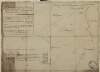
A map of the demense of Riverdale part of the lands of Grange Beg in the barony of Farbill and County of Westmeath let by Richard Allen to [illegible] Brisco Surveyed 11th Sept. 1795. Scale 20 perches to an inch. Notes on the nature of the land.
Map
Language:
English
Format:
Map
In collection:
Longfield Map Collection
Published / Created
[September 11 1795]
Notes
Physical description: 1 map Geographic Coverage: Bar...
Contributors:
“
...
Longfield
,
Robert
Ormsby
,
1844
-
1908
,
donor
...
”
Call Number:
Loading...
Located:
Loading...
A map of lands at Cloonfad in the barony of Frenchpark and County Roscommon. Names of tenants and acreage of holdings shown.
Map
Language:
English
Format:
Map
In collection:
Longfield Map Collection
Published / Created
[between 1770 and 1840]
Notes
Physical description: 1 map Geographic Coverage: Bar...
Contributors:
“
...
Longfield
,
Robert
Ormsby
,
1844
-
1908
,
donor
...
”
Call Number:
Loading...
Located:
Loading...
A map of lands at Clonavaddy and Aghaginduff in the barony of Dungannon Middle and County of Tyrone. Table of reference showing tenants acreage of holdings and condition of land.
Map
Language:
English
Format:
Map
In collection:
Longfield Map Collection
Published / Created
[between 1770 and 1840]
Notes
Physical description: 1 map Geographic Coverage: Bar...
Contributors:
“
...
Longfield
,
Robert
Ormsby
,
1844
-
1908
,
donor
...
”
Call Number:
Loading...
Located:
Loading...
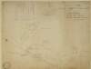
A map of lands at Drumnacopple and Derreens [Drummanacappul] in the barony of Drumahaire and County Leitrim. Scale 20 perches to an inch. Names of tenants & acreage of holdings shown.
Map
Language:
English
Format:
Map
In collection:
Longfield Map Collection
Published / Created
[between 1770 and 1840]
Notes
Physical description: 1 map Geographic Coverage: Bar...
Contributors:
“
...
Longfield
,
Robert
Ormsby
,
1844
-
1908
,
donor
...
”
Call Number:
Loading...
Located:
Loading...
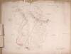
A survey of Mylerstown in the Islans of Allen barony of Great Connell and County of Kildare the estate of Thomas Hutchinson Smyth By John Brown[r]igg. 1792. Scale 20 perches to an inch. Names of adjoining tenants shown
Map
Main Creator:
Brownrigg, John, ca. 1748-1838, surveyor
Language:
English
Format:
Map
In collection:
Longfield Map Collection
Published / Created
[1792]
Notes
Physical description: 1 map Geographic Coverage: Bar...
Contributors:
“
...
Longfield
,
Robert
Ormsby
,
1844
-
1908
,
donor
...
”
Call Number:
Loading...
Located:
Loading...
Copy of maps drawn on leases for Dominick O'Reilly [of lands at Levallyroe] in the barony of Costello and County of Mayo. April 14th 1840. Scale 40 perches to an inch.
Map
Language:
English
Format:
Map
In collection:
Longfield Map Collection
Published / Created
[April 14 1840]
Notes
Physical description: 1 map Geographic Coverage: Bar...
Contributors:
“
...
Longfield
,
Robert
Ormsby
,
1844
-
1908
,
donor
...
”
Call Number:
Loading...
Located:
Loading...
A map of upper Fontstown in the Barony of Narragh & Reban East in the County of Kildare. Names of some tenants & acreages of holdings shown.
Map
Language:
English
Format:
Map
In collection:
Longfield Map Collection
Published / Created
[between 1770 and 1840]
Notes
Physical description: 1 map Geographic Coverage: Bar...
Contributors:
“
...
Longfield
,
Robert
Ormsby
,
1844
-
1908
,
donor
...
”
Call Number:
Loading...
Located:
Loading...
A survey of part of the estate of the Rt. Hon. Lord Templetown. By John Brownrigg 1800, at Drumaoib ... and Liseenan in County Monaghan. Names of tenants & acreage of holdings shown.
Map
Main Creator:
Brownrigg, John, ca. 1748-1838, surveyor
Language:
English
Format:
Map
In collection:
Longfield Map Collection
Published / Created
[1800]
Notes
Physical description: 1 map Geographic Coverage: Bar...
Contributors:
“
...
Longfield
,
Robert
Ormsby
,
1844
-
1908
,
donor
...
”
Call Number:
Loading...
Located:
Loading...
A map of part of Killeen in the Barony of Narragh & Reban East and County of Kildare. Names of tenants & area of holdings shown.
Map
Language:
English
Format:
Map
In collection:
Longfield Map Collection
Published / Created
[between 1770 and 1840]
Notes
Physical description: 1 map Geographic Coverage: Bar...
Contributors:
“
...
Longfield
,
Robert
Ormsby
,
1844
-
1908
,
donor
...
”
Call Number:
Loading...
Located:
Loading...
A survey of Mooney's holding, part of Graigues, barony of Clane County Kildare estate of Nicholas Browne. Nov. 12. 1784. Names of tenants shown on holdings
Map
Language:
English
Format:
Map
In collection:
Longfield Map Collection
Published / Created
[November 12 1784]
Notes
Physical description: 1 map Geographic Coverage: Bar...
Contributors:
“
...
Longfield
,
Robert
Ormsby
,
1844
-
1908
,
donor
...
”
Call Number:
Loading...
Located:
Loading...
A map of Ballegny in the barony of Moyashel and Magheradermon and County of Westmeath part of the estate of Sir George Tuite, Bart and surveyed in January 1775 by James Campbell. Table of reference showing tenants and acreage of holdings.
Map
Main Creator:
Campbell, James, fl. 1773-1783, surveyor
Language:
English
Format:
Map
In collection:
Longfield Map Collection
Published / Created
[January 1775]
Notes
Physical description: 1 map Geographic Coverage: Bar...
Contributors:
“
...
Longfield
,
Robert
Ormsby
,
1844
-
1908
,
donor
...
”
Call Number:
Loading...
Located:
Loading...
1
2
3
4
5
6
7
8
9
10
11
Next
48
Get RSS Feed
Email this Search
History
Narrow Search
Clear Filter
Digitised
Format
956
Map
Online Availability
Digitised
Published / Created
From:
To:
Subject
954
Boundaries (Estates)
954
Land tenure
954
Land use surveys
942
Administration of estates
142
History
47
Administration of Estates
Author
186
Longfield, John, ca. 1775-1833, surveyor
46
Brownrigg, John, ca. 1748-1838, surveyor
14
Brownrigg & Co., fl. 1801-1809, surveyors
14
Longfield, William, fl. 1825-ca. 1870, surveyor
6
Gartland, William, fl. 1838-1851/68, surveyor
5
Reading, Thomas, ca. 1704-1779, surveyor
more ...
4
Brownrigg, Longfield and Murray, fl. 1799-ca. 1805, surveyors
4
Scalé, Brownrigg & Sherrard, fl. 1774-1778, surveyors
3
Byron, Samuel, fl. 1768-1795
3
Cuddehy, Michael, fl. 1791-1803, surveyor
3
Scully, Patrick, fl. 1777, surveyor
2
Cave, Thomas, fl. ca. 1709-1749, surveyor
2
Donlevy, Bryan, fl. 1784-1792, surveyor
2
Lewis, Robert, fl. 1745-1785, surveyor
2
Lynch, Thomas, fl. 1804-1809, surveyor
2
Mulvihill, Peter, ca. 1736-d. 1798, surveyor
2
Sherrard, Thomas, ca. 1750-1837, surveyor
1
Balfe, M., fl. 1821, surveyor
1
Bell, John (I and II), fl. 1721-1820
1
Bourke, Theobald, fl. 1721-1746, surveyor
1
Boyd, Joseph, fl. 1780-1807, surveyor
1
Brassington & Gale, fl. 1832-1857, surveyors
1
Bridge, Timothy, fl. 1725-1732, surveyor
1
Browne, John, fl. 1788-ca. 1807, surveyor
1
Byrne, John, fl. 1789-1828, surveyor
1
Campbell, James, fl. 1773-1783, surveyor
1
Colbert, Thomas, fl. 1802, surveyor
1
Colbourne, Thomas, fl. 1810-1830
1
Connolly, John, fl. 1826, surveyor
1
Cooley, Garret, fl. 1787, surveyor
see all ...
less ...
Collections
956
Longfield Map Collection
Language
956
English
Genre
956
Manuscript maps
953
Maps, Manuscript
143
Early works to 1800
Era
142
18th century
1
19th century
Region
916
Ireland
182
Dublin (Ireland : County)
181
Dublin (County)
176
Kildare (County)
176
Kildare (Ireland : County)
147
Meath
more ...
147
Meath (Ireland)
111
Roscommon (County)
111
Roscommon (Ireland : County)
81
Coolock (Barony)
73
Offaly West (Barony)
39
Frenchpark (Barony)
39
Northern Ireland
34
Balrothery (Barony)
34
Castleknock (Barony)
34
Wicklow (County)
34
Wicklow (Ireland : County)
33
Westmeath
33
Westmeath (Ireland)
30
Laois
30
Laois (Ireland)
27
Kilkenny (County)
27
Kilkenny (Ireland : County)
23
Offaly
23
Offaly (Ireland)
22
Castlereagh (Barony)
21
Cavan (County)
21
Cavan (Ireland : County)
19
Mayo (County)
19
Mayo (Ireland : County)
see all ...
less ...
Loading...


![[A map of Coragleck County Fermanagh]. Names of proprietors & acres of holdings shown](/IIIF/000310000/000301950/vtls000301950_001.jp2/full/100,/0/default.jpg)


![[A map of the Botanic Gardens Glasnevin] Scale 100 Feet to an Inch](/IIIF/000310000/000301145/vtls000301145_001.jp2/full/100,/0/default.jpg)
![A map of the demense of Riverdale part of the lands of Grange Beg in the barony of Farbill and County of Westmeath let by Richard Allen to [illegible] Brisco Surveyed 11th Sept. 1795. Scale 20 perches to an inch. Notes on the nature of the land.](/IIIF/000310000/000302602/vtls000302602_001.jp2/full/100,/0/default.jpg)

![A map of lands at Drumnacopple and Derreens [Drummanacappul] in the barony of Drumahaire and County Leitrim. Scale 20 perches to an inch. Names of tenants & acreage of holdings shown.](/IIIF/000310000/000302232/vtls000302232_001.jp2/full/100,/0/default.jpg)
![A survey of Mylerstown in the Islans of Allen barony of Great Connell and County of Kildare the estate of Thomas Hutchinson Smyth By John Brown[r]igg. 1792. Scale 20 perches to an inch. Names of adjoining tenants shown](/IIIF/000310000/000301988/vtls000301988_001.jp2/full/100,/0/default.jpg)
![Copy of maps drawn on leases for Dominick O'Reilly [of lands at Levallyroe] in the barony of Costello and County of Mayo. April 14th 1840. Scale 40 perches to an inch.](/IIIF/000310000/000302347/vtls000302347_001.jp2/full/100,/0/default.jpg)