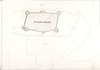
Plan of the Castle of Dublin,
circa 1600.
| Summary: | Show the Castle's position relative to Castle Street and lays out and labels the various courtwards and rooms of the Castle. |
|---|---|
| In collection: | Maps, drawings and plans by Richard Bartlett (Barthelet) and others, 1587-1625. |
| Format: | Manuscript |
| Language: | English |
| Published / Created: |
circa 1600.
|
| Subjects: | |
| Notes: | No scale is provided for this plan. Physical description: 1 sheet : 26.5 x 41 cm. more |
| Access: | Original withdrawn. Digitised images are available online. |