![[Map of Italy]](http://www.nli.ie/digital/thumbs/vtls000052842.jpg)
[Map of Italy]
[graphic].
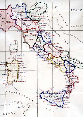
| Summary: | Map of Italy, including Sardinia and Sicily. The location of Austria and Turkey are given where the Balkans lie which shows that the Ottoman and Austro-Hungarian Empires still existed when the map was executed. |
|---|---|
| Format: | Prints & Drawings |
| Language: | English |
| Published / Created: |
[ca. 1900-1914?]
|
| Subjects: | |
| Notes: | Large folio (verso and recto) taken out of an album, combined on same sheet (folded) with Cooper's drawing of a castle beside the sea (see 2122 TX (28B)). Physical description: 1 map : ink & watercolour 24.1 x 33.6 cm. more |

