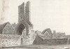
A Map of the Ruins in St. Mary's Church of Drogheda, 1780
[graphic].
| Summary: | Plan of the church of St. Mary in Drogheda, County Meath, Ireland. This is a former 13th/14th century Carmelite friary, parts of which still survive in the present Protestant Church in Mary Street, south of the river Boyne. |
|---|---|
| Format: | Prints & Drawings |
| Language: | English |
| Published / Created: |
1780.
|
| Subjects: | |
| Notes: | The stylish florishes in the handwriting and the magnetick north pointer do not seem to tally with any other identifiable hand among the drawings in this collection. Inscribed in ink m.l.: Magnetick Meridan. Inscribed in ink on verso of image: No 98 ... M Watermark visible bearing a large, crowned Britannia bearing sceptre and a bunch of flowers. From the drawing in the Austin Cooper Collection, 2122 TX (1) 82, we know that Austin Cooper visited this church in Drogheda in 1778. But the writing on this plan does not look like his hand-writing which makes it difficult to discover the historical context of this item. Physical description: 1 drawing : pen & wash ; 20 x 27.2 cm. more |
As a digital copy of this item is available, the original will not be issued.
| Call Number | View In | Collection |
|---|---|---|
|
Coo 2122 TX (3) 39 |
Collection unavailable |
Prints & Drawings |
Reproduction rights owned by National Library of Ireland.