Showing
1 - 10
results of
10
for search '
Will, John.
'
Skip to content
Toggle navigation
NLI Website
- Catalogue -
English
Gaeilge
Home
Help
Advanced Search
Browse
Orders
Ask a Librarian
Language
English
Gaeilge
All Fields
Title
Author
Subject
Call Number
ISBN/ISSN
Publisher
Coordinates
Search digitised content only
FIND
Author
Will, John.
Results
Showing
1 - 10
results of
10
for search '
Will, John.
'
, query time: 0.04s
List
Grid
Sort
Relevance
Newest First
Oldest First
Call Number
Author
Title
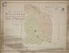
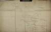
A map of the lands of Killaster situate in the barony of Castlereagh and County of Roscommon. Surveyed for the Revd. Dean French. By John Conolly. June 1826. Table of reference showing tenants and acreage of holdings. Scale 20 perches to an inch.
Map
Main Creator:
Connolly,
John
, fl. 1826, surveyor
Language:
English
Format:
Map
In collection:
Longfield Map Collection
Published / Created
[June 1826]
Notes
Physical description: 1 map Geographic Coverage: Bar...
Call Number:
Loading...
Located:
Loading...
Survey of Lisbaun Feamore and Moyvannan in the barony of Athlone and County of Roscommon the estate of Lieut. Col. F.W. French by John Longfield 1818. Scale 20 perches to an inch. Names of tenants and acreage of holdings shown.
Map
Main Creator:
Longfield,
John
, ca. 1775-1833, surveyor
Language:
English
Format:
Map
In collection:
Longfield Map Collection
Published / Created
[1818]
Notes
Physical description: 1 map Geographic Coverage: Bar...
Call Number:
Loading...
Located:
Loading...
A survey of part of the lands of Moyvannan in the barony of Athlone and County of Roscommon the estate of Col. F. W. French M.P. Surveyed by J.L. 1825. Scale 16 perches to an inch. Owen Ward's allotment shown.
Map
Main Creator:
Longfield,
John
, ca. 1775-1833, surveyor
Language:
English
Format:
Map
In collection:
Longfield Map Collection
Published / Created
[1825]
Notes
Physical description: 1 map Geographic Coverage: Bar...
Call Number:
Loading...
Located:
Loading...
A survey of Cloonkerin and Mantuar bog in the barony of Frenchpark and County of Roscommon the estate of Wiles and Oliver Grace. By J.L. March 1828. Scale 20 perches to an inch. Names of tenants acreage of holdings & condition of land shown in table of reference.
Map
Main Creator:
Longfield,
John
, ca. 1775-1833, surveyor
Language:
English
Format:
Map
In collection:
Longfield Map Collection
Published / Created
[March 1828]
Notes
Physical description: 1 map Geographic Coverage: Bar...
Call Number:
Loading...
Located:
Loading...
A survey of Doonen in the parish of Kilcolagh and barony of Frenchpark and County of Roscommon the estate of Daniel Farrell. By J Longfield March 1828. Table of reference showing tenants and acreage of holdings.
Map
Main Creator:
Longfield,
John
, ca. 1775-1833, surveyor
Language:
English
Format:
Map
In collection:
Longfield Map Collection
Published / Created
[March 1828]
Notes
Physical description: 1 map Geographic Coverage: Par...
Call Number:
Loading...
Located:
Loading...
A survey of part of the lands of Kilmore in the barony of Athlone and County Roscommon part of the estate of Henry Carter. By J.L. 1817. Scale 20 perches to an inch. Names of tenants and acreage of holdings shown.
Map
Main Creator:
Longfield,
John
, ca. 1775-1833, surveyor
Language:
English
Format:
Map
In collection:
Longfield Map Collection
Published / Created
[1817]
Notes
Physical description: 1 map Geographic Coverage: Bar...
Call Number:
Loading...
Located:
Loading...
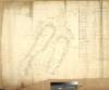
A map and sections of the Tulsk river ... Surveyed and levelled by John Longfield. 1829.
Map
Main Creator:
Longfield,
John
, ca. 1775-1833, surveyor
Language:
English
Format:
Map
In collection:
Longfield Map Collection
Published / Created
[1829]
Notes
Physical description: 1 map Geographic Coverage: Bar...
Call Number:
Loading...
Located:
Loading...
A survey of the disputed bounds between the lands of Creevy the estate of Lord Dillon and Corracoggil the estate of Arthur French in the barony of Frenchpark Co. Roscommon on which are traced the links of said boundary as per Thomas Cuttle's map of 1770 and Sherrard and Brassingtons map 1792. Surveyed and laid down by John Longfield in July 1826.
Map
Main Creator:
Longfield,
John
, ca. 1775-1833, surveyor
Language:
English
Format:
Map
In collection:
Longfield Map Collection
Published / Created
[July 1826]
Notes
Physical description: 1 map Geographic Coverage: Bar...
Call Number:
Loading...
Located:
Loading...
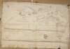
A map of the several estates of John Hearn and Henry Trant at Carrowreagh ... and Lissalway situate in the County of Roscommon and barony of Castlereagh. Surveyed by Brownrigg Longfield and Murray. 1802. Scale 20 perches to an inch. Names of tenants and acreage of holdings shown.
Map
Main Creator:
Brownrigg, Longfield and Murray, fl. 1799-ca. 1805, surveyors
Language:
English
Format:
Map
In collection:
Longfield Map Collection
Published / Created
[1802]
Notes
Physical description: 1 map Geographic Coverage: Bar...
Contributors:
“
...Longfield,
John
, ca. 1775-1833, surveyor...
”
Call Number:
Loading...
Located:
Loading...
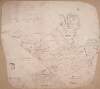
A rough draft of lands at Ardass Rathleg Rathbarna ... and Carrawgarve in the barony of Castlereagh and County of Roscommon copied from a survey made of the above lands by John Kelly in the year 1699 and copied by M. Balfe in March 1821.
Map
Main Creator:
Balfe, M., fl. 1821, surveyor
Language:
English
Format:
Map
In collection:
Longfield Map Collection
Published / Created
[March 1821]
Notes
Physical description: 1 map Geographic Coverage: Bar...
Contributors:
“
...Kelly,
John
, fl. 1699, surveyor...
”
Call Number:
Loading...
Located:
Loading...
Get RSS Feed
Email this Search
History
Narrow Search
Digitised
Remove Filters
Clear Filter
Subject: Land use surveys
Clear Filter
Region: Roscommon (Ireland : County)
Format
10
Map
Online Availability
10
Digitised
Published / Created
From:
To:
Subject
10
Administration of estates
10
Boundaries (Estates)
10
Land tenure
Land use surveys
Author
7
Longfield, John, ca. 1775-1833, surveyor
1
Balfe, M., fl. 1821, surveyor
1
Brownrigg, Longfield and Murray, fl. 1799-ca. 1805, surveyors
1
Connolly, John, fl. 1826, surveyor
Collections
10
Longfield Map Collection
Language
10
English
Genre
10
Manuscript maps
10
Maps, Manuscript
Region
10
Ireland
10
Roscommon (County)
Roscommon (Ireland : County)
3
Athlone (Barony)
3
Castlereagh (Barony)
3
Frenchpark (Barony)
more ...
1
Kilcolagh Parish
1
Kilcolagh Parish (Ireland)
1
Roscommon (Barony)
see all ...
less ...
Loading...