Showing
101 - 120
results of
526
for search '
Will, John.
'
Skip to content
Toggle navigation
NLI Website
- Catalogue -
English
Gaeilge
Home
Help
Advanced Search
Browse
Orders
Ask a Librarian
Language
English
Gaeilge
All Fields
Title
Author
Subject
Call Number
ISBN/ISSN
Publisher
Coordinates
Search digitised content only
FIND
Author
Will, John.
Results
Showing
101 - 120
results of
526
for search '
Will, John.
'
, query time: 0.04s
List
Grid
Sort
Relevance
Newest First
Oldest First
Call Number
Author
Title
1
Previous
1
2
3
4
5
6
7
8
9
10
11
Next
27
A map of a lot of ground on the North Wall [Guild Street] in the City of Dublin belonging to Messrs Booker. Surveyed by John Longfield 1814. Name of adjoining tenant shown
Map
Main Creator:
Longfield,
John
, ca. 1775-1833, surveyor
Language:
English
Format:
Map
In collection:
Longfield Map Collection
Published / Created
[1814]
Notes
Physical description: 1 map Geographic Coverage: Dub...
Call Number:
Loading...
Located:
Loading...
A map of a Holding [No.17] on the North side of Cook St in the City of Dublin, let by [illegible] Ball Esq. to Mr. Egan. Surveyed by J. Longfield Dec 1809
Map
Main Creator:
Longfield,
John
, ca. 1775-1833, surveyor
Language:
English
Format:
Map
In collection:
Longfield Map Collection
Published / Created
[December 1809]
Notes
Physical description: 1 map Geographic Coverage: Dub...
Call Number:
Loading...
Located:
Loading...
A map of a piece of ground on the east side of West Arran St & south end of Smithfield in the City of Dublin, part of the estate of Lord Mendip. Surveyed by J. Longfield, April 1824. Names of tenants shown on holdings
Map
Main Creator:
Longfield,
John
, ca. 1775-1833, surveyor
Language:
English
Format:
Map
In collection:
Longfield Map Collection
Published / Created
[April 1824]
Notes
Physical description: 1 map Geographic Coverage: Dub...
Call Number:
Loading...
Located:
Loading...
A map of part of the Commons of Fox & Geese in the County of Dublin allotted to the most noble the Marquis of Lansdowne. Surveyed & divided by John Longfield June 1820. Scale 10 Perches to an Inch
Map
Main Creator:
Longfield,
John
, ca. 1775-1833, surveyor
Language:
English
Format:
Map
In collection:
Longfield Map Collection
Published / Created
[June 1820]
Notes
Physical description: 1 map Geographic Coverage: Bar...
Call Number:
Loading...
Located:
Loading...
A map of part of the estate of Wm. Sherlock on Dame Street in the City of Dublin. Surveyed by J. Brownrigg 1799. Scale 20 feet to an inch. References to tenants and leases
Map
Main Creator:
Brownrigg,
John
, ca. 1748-1838, surveyor
Language:
English
Format:
Map
In collection:
Longfield Map Collection
Published / Created
[1799]
Notes
Physical description: 1 map Geographic Coverage: Dub...
Call Number:
Loading...
Located:
Loading...
A map of the town of Durmona the joint estate of Lady de Clifford and Sir J. Rowley. Surveyed by J. Longfield. Names of tenants 7 area of holdings shown on properties.
Map
Main Creator:
Longfield,
John
, ca. 1775-1833, surveyor
Language:
English
Format:
Map
In collection:
Longfield Map Collection
Published / Created
[between 1770 and 1840]
Notes
Inset maps: "A map of part of the lands of Lisduff le...
Call Number:
Loading...
Located:
Loading...
A map of premises situate on the east side of Fishamble Street formerly in the tenure of Mrs. Nugent. Surveyed by John Longfield, 1831. Names of tenants shown on holdings
Map
Main Creator:
Longfield,
John
, ca. 1775-1833, surveyor
Language:
English
Format:
Map
In collection:
Longfield Map Collection
Published / Created
[1831]
Notes
Physical description: 1 map Geographic Coverage: Dub...
Call Number:
Loading...
Located:
Loading...
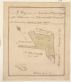
A survey of the Lands of Ballyglassin in the Barony of Emokilleagh [Imokilly] & County of Cork - the Estate of the Revd. Doct. Synge. March 1808. J.L.
Map
Main Creator:
Longfield,
John
, ca. 1775-1833, surveyor
Language:
English
Format:
Map
In collection:
Longfield Map Collection
Published / Created
[March 1808]
Notes
Physical description: 1 map Geographic Coverage: Bar...
Call Number:
Loading...
Located:
Loading...
A map of the lands of Knocksonna in the barony of Coshma and County of Limerick the estate of Grange Ormsby. By J. L. 1805. Scale 20 perches to an inch. Table of reference showing tenants names & acreage of holdings, similar references on map.
Map
Main Creator:
Longfield,
John
, ca. 1775-1833, surveyor
Language:
English
Format:
Map
In collection:
Longfield Map Collection
Published / Created
[1805]
Notes
Physical description: 1 map Geographic Coverage: Bar...
Call Number:
Loading...
Located:
Loading...
A survey on the Naas Road [?] Rathcoole of part of Miss Robins ... Estate 1827. Surveyed June 1827 by J. Longfield. Scale 8 Perches to an Inch.
Map
Main Creator:
Longfield,
John
, ca. 1775-1833, surveyor
Language:
English
Format:
Map
In collection:
Longfield Map Collection
Published / Created
[June 1827]
Notes
Physical description: 1 map Geographic Coverage: Bar...
Call Number:
Loading...
Located:
Loading...
A survey of the estate of John Bagwell at Shanbally Kilmore and Lisronagh in the barony of Iffa and Offa East and County of Tipperary. By J.L. July 1815. Names of tenants and acreage of holdings shown.
Map
Main Creator:
Longfield,
John
, ca. 1775-1833, surveyor
Language:
English
Format:
Map
In collection:
Longfield Map Collection
Published / Created
[July 1815]
Notes
Physical description: 1 map Geographic Coverage: Bar...
Call Number:
Loading...
Located:
Loading...
Section of that part of the river Blackwater between Ratholdron weir and the Dhuoag stream at Mullahard in the County of Meath. Surveyed by John Long under the direction of William F. Mulvany C.E.
Map
Main Creator:
Longfield,
John
, ca. 1775-1833, surveyor
Language:
English
Format:
Map
In collection:
Longfield Map Collection
Published / Created
[between 1795 and 1833]
Notes
For other sections of the river Blackwater see MS 21...
Call Number:
Loading...
Located:
Loading...
A survey of Carn in the barony of Fore and County of Westmeath part of the estate of the Rt. Hon. the Earl of Longford. By John Brownrigg 1799. Scale of 20 perches to an inch. Table of reference showing acreage and nature of land.
Map
Main Creator:
Brownrigg,
John
, ca. 1748-1838, surveyor
Language:
English
Format:
Map
In collection:
Longfield Map Collection
Published / Created
[1799]
Notes
Physical description: 1 map Geographic Coverage: Bar...
Call Number:
Loading...
Located:
Loading...
A map of a piece of ground on the west side of Lr Exchange St. in the City of Dublin. By J.L. 1812. Names of adjoining tenants shown.
Map
Main Creator:
Longfield,
John
, ca. 1775-1833, surveyor
Language:
English
Format:
Map
In collection:
Longfield Map Collection
Published / Created
[1812]
Notes
Physical description: 1 map Geographic Coverage: Dub...
Call Number:
Loading...
Located:
Loading...
A survey of the lands of Mullanevally [Mullaghavally] in the barony of Lower Kells and County of Meath the estate of Thomas S. Whyte. By J. L. 1822. Scale 20 perches to an inch. Tenants names & acreage of holdings shown.
Map
Main Creator:
Longfield,
John
, ca. 1775-1833, surveyor
Language:
English
Format:
Map
In collection:
Longfield Map Collection
Published / Created
[1822]
Notes
Physical description: 1 map Geographic Coverage: Bar...
Call Number:
Loading...
Located:
Loading...
A survey of a holding at St. Stephen's Green held by Mr. Thomas Glynn under Peter Digges Latouche Esq. Done by John Brownrigg Nov 23 1787. Scale 20 Feet to an Inch
Map
Main Creator:
Brownrigg,
John
, ca. 1748-1838, surveyor
Language:
English
Format:
Map
In collection:
Longfield Map Collection
Published / Created
[November 23 1787]
Notes
Physical description: 1 map Geographic Coverage: Dub...
Call Number:
Loading...
Located:
Loading...
A map of the Lands of Gracedien and its subdenominations in the Barony of Balrothery & County of Dublin, the Estate of John Venox Esq. by John Brownrigg. November 1794. Scale 20 Perches to an Inch
Map
Main Creator:
Brownrigg,
John
, ca. 1748-1838, surveyor
Language:
English
Format:
Map
In collection:
Longfield Map Collection
Published / Created
[November 1794]
Notes
Physical description: 1 map Geographic Coverage: Bar...
Call Number:
Loading...
Located:
Loading...
A map of part of the lands of Drummin [Drummond] in the barony of [Upper] Moyfenrath and County of Meath part of the estate of Lady Jane Loftus. Surveyed by J Longfield 1820. Names of tenants shown on holdings. Table of reference with tenants names acreage of holdings
Map
Main Creator:
Longfield,
John
, ca. 1775-1833, surveyor
Language:
English
Format:
Map
In collection:
Longfield Map Collection
Published / Created
[1820]
Notes
Significant staining on the map. A large sticker from...
Call Number:
Loading...
Located:
Loading...
A map of Part of the Lands of Stillorgan the Property of N. Lefavre Esq. Laid out in Lots for Building, by J. Brownrigg 1792. Scale 100 Feet to an Inch
Map
Main Creator:
Brownrigg,
John
, ca. 1748-1838, surveyor
Language:
English
Format:
Map
In collection:
Longfield Map Collection
Published / Created
[1792]
Notes
Physical description: 1 map Geographic Coverage: Bar...
Call Number:
Loading...
Located:
Loading...
A map of part of the Lands of St. Dowlaghs call'd Bohomer with Church & Chh. ground, the estate of the Chantor of Christ Church. Survey'd by J. Longfield 1815. Scale 20 Perches to an Inch
Map
Main Creator:
Longfield,
John
, ca. 1775-1833, surveyor
Language:
English
Format:
Map
In collection:
Longfield Map Collection
Published / Created
[1815]
Notes
Physical description: 1 map Geographic Coverage: Bar...
Call Number:
Loading...
Located:
Loading...
1
Previous
1
2
3
4
5
6
7
8
9
10
11
Next
27
Get RSS Feed
Email this Search
History
Narrow Search
Digitised
Remove Filters
Clear Filter
Subject: Boundaries (Estates)
Format
526
Map
Online Availability
264
Digitised
262
Not Digitised
Published / Created
From:
To:
Subject
Boundaries (Estates)
526
Land tenure
526
Land use surveys
516
Administration of estates
126
History
19
Administration of Estates
Author
335
Longfield, John, ca. 1775-1833, surveyor
112
Brownrigg, John, ca. 1748-1838, surveyor
42
Brownrigg & Co., fl. 1801-1809, surveyors
7
Brownrigg, Longfield and Murray, fl. 1799-ca. 1805, surveyors
6
Longfield, William, fl. 1825-ca. 1870, surveyor
4
Scalé, Brownrigg & Sherrard, fl. 1774-1778, surveyors
more ...
3
Roe, John, fl. 1793-1824, surveyor
2
Brownrigg & Sherrard, fl. 1777-1778, surveyors
2
Byrne, John, fl. 1789-1828, surveyor
2
Moynahan, John, fl. 1736-1764, surveyor
1
Balfe, M., fl. 1821, surveyor
1
Battersby, John, fl. 1778, surveyor
1
Bell, John (I and II), fl. 1721-1820
1
Browne, John, fl. 1788-ca. 1807, surveyor
1
Connolly, John, fl. 1826, surveyor
1
Kelly, John, fl. 1820-1852, surveyor
1
Logan, John, fl. 1827-1846, surveyor
1
Molloy, John, fl. 1809-1839, surveyor
1
Netterville, John, fl. 1747-1768, surveyor
1
O'Brien, John, fl. 1784-1820, surveyor
1
Wright, John, fl. 1759-1775, surveyor
see all ...
less ...
Collections
526
Longfield Map Collection
Language
526
English
Genre
526
Manuscript maps
526
Maps, Manuscript
126
Early works to 1800
Era
126
18th century
Region
522
Ireland
321
Dublin (Ireland : County)
320
Dublin (County)
130
Dublin (Ireland)
127
Dublin
58
Meath
more ...
58
Meath (Ireland)
57
Rathdown (Barony)
49
Kildare (County)
49
Kildare (Ireland : County)
40
Coolock (Barony)
27
Uppercross (Barony)
21
Newcastle (Barony)
18
Offaly West (Barony)
17
Dublin (Barony)
16
Castleknock (Barony)
16
Dublin City (Barony)
16
Nethercross (Barony)
13
Wicklow (County)
13
Wicklow (Ireland : County)
12
Westmeath
12
Westmeath (Ireland)
11
Balrothery (Barony)
10
Roscommon (County)
10
Roscommon (Ireland : County)
9
Duleek Upper (Barony)
9
Laois
9
Laois (Ireland)
8
Tipperary (County)
8
Tipperary (Ireland : County)
see all ...
less ...
Loading...

![A survey of the Lands of Ballyglassin in the Barony of Emokilleagh [Imokilly] & County of Cork - the Estate of the Revd. Doct. Synge. March 1808. J.L.](/IIIF/000310000/000301920/vtls000301920_001.jp2/full/100,/0/default.jpg)


![A survey of the lands of Mullanevally [Mullaghavally] in the barony of Lower Kells and County of Meath the estate of Thomas S. Whyte. By J. L. 1822. Scale 20 perches to an inch. Tenants names & acreage of holdings shown.](/IIIF/000310000/000301770/vtls000301770_001.jp2/full/100,/0/default.jpg)

![A map of part of the lands of Drummin [Drummond] in the barony of [Upper] Moyfenrath and County of Meath part of the estate of Lady Jane Loftus. Surveyed by J Longfield 1820. Names of tenants shown on holdings. Table of reference with tenants names acreage of holdings](/IIIF/000310000/000301970/vtls000301970_001.jp2/full/100,/0/default.jpg)