Showing
1 - 20
results of
526
for search '
Will, John.
'
Skip to content
Toggle navigation
NLI Website
- Catalogue -
English
Gaeilge
Home
Help
Advanced Search
Browse
Orders
Ask a Librarian
Language
English
Gaeilge
All Fields
Title
Author
Subject
Call Number
ISBN/ISSN
Publisher
Coordinates
Search digitised content only
FIND
Author
Will, John.
Results
Showing
1 - 20
results of
526
for search '
Will, John.
'
, query time: 0.05s
List
Grid
Sort
Relevance
Newest First
Oldest First
Call Number
Author
Title
1
2
3
4
5
6
7
8
9
10
11
Next
27
Reverend John O'Rorke account of rents,
12 August 1818.
Map
Main Creator:
O'Rorke,
John
, Reverend.
Language:
English
Format:
Map
In collection:
Bellew of Mount Bellew Papers
Published / Created
12 August 1818.
Notes
Rental bears the title: Reverend John O'Rorke, accoun...
Call Number:
Loading...
Located:
Loading...
View Context
[A plan of holdings in the neighbourhood of Dolphins Barn] by John Battersby 1778
Map
Main Creator:
Battersby,
John
, fl. 1778, surveyor
Language:
English
Format:
Map
In collection:
Longfield Map Collection
Published / Created
[1778]
Notes
Physical description: 1 map Geographic Coverage: Bar...
Call Number:
Loading...
Located:
Loading...
A map of the lands of Killaster situate in the barony of Castlereagh and County of Roscommon. Surveyed for the Revd. Dean French. By John Conolly. June 1826. Table of reference showing tenants and acreage of holdings. Scale 20 perches to an inch.
Map
Main Creator:
Connolly,
John
, fl. 1826, surveyor
Language:
English
Format:
Map
In collection:
Longfield Map Collection
Published / Created
[June 1826]
Notes
Physical description: 1 map Geographic Coverage: Bar...
Call Number:
Loading...
Located:
Loading...
A map of part of the lands at Kelshamore in the barony of Talbotstown Upper and County of Wicklow the estate of the Rev Sir S.S. Hutchinson, Bart let to Edward Flynn, Senior. Surveyed by John Longfield 1813. Scale 20 perches to an inch.
Map
Main Creator:
Longfield,
John
, ca. 1775-1833, surveyor
Language:
English
Format:
Map
In collection:
Longfield Map Collection
Published / Created
[1813]
Notes
Physical description: 1 map Geographic Coverage: Bar...
Call Number:
Loading...
Located:
Loading...
A map of the precincts of Christ Church showing the part about to be purchased by the Commissioners of Wide Streets. Surveyed by J.L. 1817. Names of tenants on Skinner Row. Shown on properties
Map
Main Creator:
Longfield,
John
, ca. 1775-1833, surveyor
Language:
English
Format:
Map
In collection:
Longfield Map Collection
Published / Created
[1817]
Notes
Physical description: 1 map Geographic Coverage: Dub...
Call Number:
Loading...
Located:
Loading...
A map of the lands of Lismore, the estate of William Carden, and adjoining townlands in the parish of Aghaboe and barony of Clandonagh surveyed to ascertain the bounds of lands between the Duchens of Chandos and William Carden by John Longfield 1809.
Map
Main Creator:
Longfield,
John
, ca. 1775-1833, surveyor
Language:
English
Format:
Map
In collection:
Longfield Map Collection
Published / Created
[1809].
Notes
Physical description: 1 map Geographic Coverage: Par...
Call Number:
Loading...
Located:
Loading...
A map of the glebe lands of Killenaule in the barony of Slievardagh and County of Tipperary belonging to the Chancellor of Christ Church. Surveyed and traced by J.L. 1817. Names of tenants shown & table of reference with tenants names & area of holdings. With additional list 4 January 1833 laid out and possession taken by Sheriff.
Map
Main Creator:
Longfield,
John
, ca. 1775-1833, surveyor
Language:
English
Format:
Map
In collection:
Longfield Map Collection
Published / Created
[1817]
Notes
Physical description: 1 map Geographic Coverage: Bar...
Call Number:
Loading...
Located:
Loading...
A map of a parcel of ground in St. Sepulchres in the County of Dublin let by John Hatch to Robert Watson Wade and Edward Whitton. Surveyed by John Brownrigg. June-Aug 1791. Scale 100 feet to an inch.
Map
Main Creator:
Brownrigg,
John
, ca. 1748-1838, surveyor
Language:
English
Format:
Map
In collection:
Longfield Map Collection
Published / Created
[June 1791]
Notes
In mylar covering. Physical description: 1 map Geogr...
Call Number:
Loading...
Located:
Loading...
A map of that part of the Royal Canal intended to pass through the County of Dublin from Summer Hill to Ashtown. By John Brownrigg 1790. Scale 500 feet to an Inch. Table of reference showing denominations Proprietors Leases under-Tenants & remarks on the properties
Map
Main Creator:
Brownrigg,
John
, ca. 1748-1838, surveyor
Language:
English
Format:
Map
In collection:
Longfield Map Collection
Published / Created
[1790]
Notes
Physical description: 1 map Geographic Coverage: Dub...
Call Number:
Loading...
Located:
Loading...
A map of a lot of ground on the east side of St. Michaels Lane in the City of Dublin the estate of the Dean & Chapter of Christ Church let to John H. Burgess. Surveyed by John Longfield 1815. Nowlans holding shown.
Map
Main Creator:
Longfield,
John
, ca. 1775-1833, surveyor
Language:
English
Format:
Map
In collection:
Longfield Map Collection
Published / Created
[1815]
Notes
Physical description: 1 map Geographic Coverage: Dub...
Call Number:
Loading...
Located:
Loading...
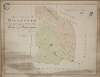
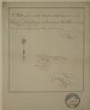
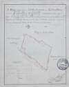
A survey of Mylerstown in the Islans of Allen barony of Great Connell and County of Kildare the estate of Thomas Hutchinson Smyth By John Brown[r]igg. 1792. Scale 20 perches to an inch. Names of adjoining tenants shown
Map
Main Creator:
Brownrigg,
John
, ca. 1748-1838, surveyor
Language:
English
Format:
Map
In collection:
Longfield Map Collection
Published / Created
[1792]
Notes
Physical description: 1 map Geographic Coverage: Bar...
Call Number:
Loading...
Located:
Loading...
A survey of part of the farm of St. Sepulchre's in the County of Dublin let by His Grace Robert Lord Archbishop of Dublin to Mr. Francis Usher. By John Brownrigg 1782. Scale 400 feet to an inch
Map
Main Creator:
Brownrigg,
John
, ca. 1748-1838, surveyor
Language:
English
Format:
Map
In collection:
Longfield Map Collection
Published / Created
[1782]
Notes
Physical description: 1 map Geographic Coverage: Dub...
Call Number:
Loading...
Located:
Loading...
A map of the demense and lands of Williamstown in the barony of Kells Upper and County of Meath. Surveyed in May 1824 by John Roe. Scale 20 perches to an inch. On reverse - a letter from John Longfield, 18 January 1825, On the condition of the house & lands & their probable value.
Map
Main Creator:
Roe,
John
, fl. 1793-1824, surveyor
Language:
English
Format:
Map
In collection:
Longfield Map Collection
Published / Created
[May 1824]
Notes
Physical description: 1 map Geographic Coverage: Bar...
Call Number:
Loading...
Located:
Loading...
A map of lands at Lyonstown part of Lord Derby's estate ... in the barony of Middlethird and County of Tipperary. By John Longfield, July 1824. Names of tenants and acreage of lands shown.
Map
Main Creator:
Longfield,
John
, ca. 1775-1833, surveyor
Language:
English
Format:
Map
In collection:
Longfield Map Collection
Published / Created
[July 1824]
Notes
Physical description: 1 map Geographic Coverage: Bar...
Call Number:
Loading...
Located:
Loading...
A survey of two fields on Rathmines Road part of the Estate of the Right Honble. the Earl of Meath, by John Brownrigg. Oct. 1791
Map
Main Creator:
Brownrigg,
John
, ca. 1748-1838, surveyor
Language:
English
Format:
Map
In collection:
Longfield Map Collection
Published / Created
[October 1791]
Notes
Physical description: 1 map Geographic Coverage: Bar...
Call Number:
Loading...
Located:
Loading...
A map of part of the Glebe lands of Kilcullen in the County of Kildare, granted by the Rev. Thomas Brownrigg Chancellor of the cathedral church of the Holy and Undivided Trinity Dublin to the Rev. J. Hardy and his successors as an additional Glebe to the parish of Killcullen. Surveyed by John Longfield 1822. Scale 20 perches to an inch. Table of reference showing tenants names & area of holdings.
Map
Main Creator:
Longfield,
John
, ca. 1775-1833, surveyor
Language:
English
Format:
Map
In collection:
Longfield Map Collection
Published / Created
[1822]
Notes
Physical description: 1 map Geographic Coverage: Par...
Call Number:
Loading...
Located:
Loading...
A mapp of a lott of ground situate west side of Drogheda St. Monasterevin ... Surveyed by J Longfield. 1809. Scale 4 perches to an inch.
Map
Main Creator:
Longfield,
John
, ca. 1775-1833, surveyor
Language:
English
Format:
Map
In collection:
Longfield Map Collection
Published / Created
[1809]
Notes
In mylar covering. Physical description: 1 map Geogr...
Call Number:
Loading...
Located:
Loading...
A survey of a holding on the east side of Meath Street, Dublin, the property of the poor of the parish of St. Catherines, the Rev. J. D. Hastings Vicar. Surveyed, Nov. 1829. By J.L. Names of tenants shown on properties
Map
Main Creator:
Longfield,
John
, ca. 1775-1833, surveyor
Language:
English
Format:
Map
In collection:
Longfield Map Collection
Published / Created
[November 1829]
Notes
Physical description: 1 map Geographic Coverage: Dub...
Call Number:
Loading...
Located:
Loading...
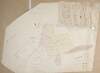
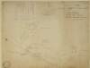
A survey of the lands of Bedlowstown [Bellewstown] in the lower barony of Navan and County of Meath part of the estate of Nathanill Preston. Surveyed April 1813. By John Longfield. Names of tenants and acreage of holdings shown.
Map
Main Creator:
Longfield,
John
, ca. 1775-1833, surveyor
Language:
English
Format:
Map
In collection:
Longfield Map Collection
Published / Created
[April 1813]
Notes
Physical description: 1 map Geographic Coverage: Bar...
Call Number:
Loading...
Located:
Loading...
A map of Kill of the Grange in the Barony of Rathdown and County of Dn. part of the Estate of the Right Honble. & Rt. Revd. Charles Lord Bishop of Kildare - as Dean of Christ Church let to Isaac Espinasse Esq. Survey'd by J.L. 1814. Scale 20 Perches to an Inch
Map
Main Creator:
Longfield,
John
, ca. 1775-1833, surveyor
Language:
English
Format:
Map
In collection:
Longfield Map Collection
Published / Created
[1814]
Notes
Physical description: 1 map Geographic Coverage: Bar...
Call Number:
Loading...
Located:
Loading...
1
2
3
4
5
6
7
8
9
10
11
Next
27
Get RSS Feed
Email this Search
History
Narrow Search
Digitised
Remove Filters
Clear Filter
Subject: Administration of estates
Clear Filter
Format: Map
Format
Map
Online Availability
271
Not Digitised
255
Digitised
Published / Created
From:
To:
Subject
Administration of estates
524
Land use surveys
520
Land tenure
516
Boundaries (Estates)
126
History
9
Administration of Estates
more ...
8
Estates
4
Cartography
4
Eviction
4
Farm rents
4
Landlord and tenant
4
Maps and Surveys
4
Surveyors
4
Tenant farmers
1
Maps, Manuscript
see all ...
less ...
Author
327
Longfield, John, ca. 1775-1833, surveyor
112
Brownrigg, John, ca. 1748-1838, surveyor
42
Brownrigg & Co., fl. 1801-1809, surveyors
7
Brownrigg, Longfield and Murray, fl. 1799-ca. 1805, surveyors
6
Longfield, William, fl. 1825-ca. 1870, surveyor
4
Scalé, Brownrigg & Sherrard, fl. 1774-1778, surveyors
more ...
3
Roe, John, fl. 1793-1824, surveyor
2
Altamont, Earls of
2
Brownrigg & Sherrard, fl. 1777-1778, surveyors
2
Byrne, John, fl. 1789-1828, surveyor
2
Logan, John, fl. 1827-1846, surveyor
2
Moynahan, John, fl. 1736-1764, surveyor
2
O'Brien, William, 1881-1968
1
Balfe, M., fl. 1821, surveyor
1
Battersby, John, fl. 1778, surveyor
1
Bell, John (I and II), fl. 1721-1820
1
Browne, John, fl. 1788-ca. 1807, surveyor
1
Connolly, John, fl. 1826, surveyor
1
Kelly, John, fl. 1820-1852, surveyor
1
Kennedy, Robert
1
Molloy, John, fl. 1809-1839, surveyor
1
Netterville, John, fl. 1747-1768, surveyor
1
O'Brien, John, fl. 1784-1820, surveyor
1
O'Rorke, John, Reverend
1
Wright, John, fl. 1759-1775, surveyor
see all ...
less ...
Collections
516
Longfield Map Collection
4
vtls000364409
2
Bellew of Mount Bellew Papers
2
Westport Estate papers, 1540-1993.
Language
526
English
Genre
520
Manuscript maps
516
Maps, Manuscript
126
Early works to 1800
2
Maps
Era
126
18th century
1
1791-1862
1
19th century
Region
522
Ireland
321
Dublin (Ireland : County)
320
Dublin (County)
130
Dublin (Ireland)
127
Dublin
57
Rathdown (Barony)
more ...
49
Kildare (County)
49
Kildare (Ireland : County)
48
Meath
48
Meath (Ireland)
40
Coolock (Barony)
27
Uppercross (Barony)
21
Newcastle (Barony)
18
Offaly West (Barony)
17
Dublin (Barony)
16
Castleknock (Barony)
16
Dublin City (Barony)
16
Nethercross (Barony)
13
Wicklow (County)
13
Wicklow (Ireland : County)
12
Westmeath
12
Westmeath (Ireland)
11
Balrothery (Barony)
10
Roscommon (County)
10
Roscommon (Ireland : County)
9
Duleek Upper (Barony)
9
Laois
9
Laois (Ireland)
8
Tipperary (County)
8
Tipperary (Ireland : County)
see all ...
less ...
Loading...
![A survey of Mylerstown in the Islans of Allen barony of Great Connell and County of Kildare the estate of Thomas Hutchinson Smyth By John Brown[r]igg. 1792. Scale 20 perches to an inch. Names of adjoining tenants shown](/IIIF/000310000/000301988/vtls000301988_001.jp2/full/100,/0/default.jpg)

![A survey of the lands of Bedlowstown [Bellewstown] in the lower barony of Navan and County of Meath part of the estate of Nathanill Preston. Surveyed April 1813. By John Longfield. Names of tenants and acreage of holdings shown.](/IIIF/000310000/000301841/vtls000301841_001.jp2/full/100,/0/default.jpg)