Showing
1 - 4
results of
4
for search '
Reading, Thomas, ca. 1704-1779, surveyor
'
Skip to content
Toggle navigation
NLI Website
- Catalogue -
English
Gaeilge
Home
Help
Advanced Search
Browse
Orders
Ask a Librarian
Language
English
Gaeilge
All Fields
Title
Author
Subject
Call Number
ISBN/ISSN
Publisher
Coordinates
Search digitised content only
FIND
Author
Reading, Thomas, ca. 1704-1779, surveyor
Results
Showing
1 - 4
results of
4
for search '
Reading, Thomas, ca. 1704-1779, surveyor
'
, query time: 0.15s
List
Grid
Sort
Relevance
Newest First
Oldest First
Call Number
Author
Title
A map of several parcels of the townland of Glasnevin in the County of Dublin, called Fosters Farm, belonging to the Dean of Christ Church Dublin. Surveyed in May 1768 by Tho Reading.
Map
Main Creator:
Reading
,
Thomas
,
ca
.
1704
-
1779
,
surveyor
Language:
English
Format:
Map
In collection:
Longfield Map Collection
Published / Created
[May 1768]
Notes
Physical description: 1 map Geographic Coverage: Bar...
Call Number:
Loading...
Located:
Loading...
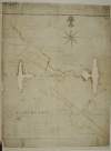
Map of Part of the Lands of [Fausagh] Fausogh in the Parish of Glasnevin. Partly traced from a Survey made by Richd. Francis A.D. 1640 & partly from a survey by Thos. Reading A.D. 1768.
Map
Main Creator:
Reading
,
Thomas
,
ca
.
1704
-
1779
,
surveyor
Language:
English
Format:
Map
In collection:
Longfield Map Collection
Published / Created
[1768]
Notes
Physical description: 1 map Geographic Coverage: Par...
Call Number:
Loading...
Located:
Loading...
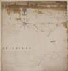
Copy of a map of several parcell's of Land - part of the Lands of Cottrellstown and Weystown. Barony of Balrothery in the County of Dublin, belonging to the Vicars and Prebends of Christ Church Dublin. Surveyed in June 1751. By Thos. Reading. [with copy of Indenture]
Map
Main Creator:
Reading
,
Thomas
,
ca
.
1704
-
1779
,
surveyor
Language:
English
Format:
Map
In collection:
Longfield Map Collection
Published / Created
[June 1751]
Notes
Physical description: 1 map Geographic Coverage: Bar...
Call Number:
Loading...
Located:
Loading...
A map of part of the Lands of Turvey in the Parish of Donabate Barony of Balrothery and County of Dublin, part of the Estate belonging to the Rt. Honble. the Ld. Kingsland. Surveyed in October 1768 by Thos. Reading.
Map
Main Creator:
Reading
,
Thomas
,
ca
.
1704
-
1779
,
surveyor
Language:
English
Format:
Map
In collection:
Longfield Map Collection
Published / Created
[October 1768]
Notes
Physical description: 1 map Geographic Coverage: Par...
Call Number:
Loading...
Located:
Loading...
Get RSS Feed
Email this Search
History
Narrow Search
Clear Filter
Digitised
Remove Filters
Clear Filter
Era: 18th century
Format
4
Map
Online Availability
Digitised
Published / Created
From:
To:
Subject
4
Administration of estates
4
Boundaries (Estates)
4
History
4
Land tenure
4
Land use surveys
Author
4
Reading, Thomas, ca. 1704-1779, surveyor
Collections
4
Longfield Map Collection
Language
4
English
Genre
4
Early works to 1800
4
Manuscript maps
4
Maps, Manuscript
Era
18th century
Region
4
Dublin (County)
4
Dublin (Ireland : County)
4
Ireland
2
Balrothery (Barony)
2
Coolock (Barony)
1
Donabate Parish
more ...
1
Donabate Parish (Ireland)
1
Glasnevin Parish
1
Glasnevin Parish (Ireland)
see all ...
less ...
Loading...
![Map of Part of the Lands of [Fausagh] Fausogh in the Parish of Glasnevin. Partly traced from a Survey made by Richd. Francis A.D. 1640 & partly from a survey by Thos. Reading A.D. 1768.](/IIIF/000310000/000301146/vtls000301146_001.jp2/full/100,/0/default.jpg)
![Copy of a map of several parcell's of Land - part of the Lands of Cottrellstown and Weystown. Barony of Balrothery in the County of Dublin, belonging to the Vicars and Prebends of Christ Church Dublin. Surveyed in June 1751. By Thos. Reading. [with copy of Indenture]](/IIIF/000310000/000302265/vtls000302265_001.jp2/full/100,/0/default.jpg)