Showing
1 - 20
results of
264
for search '
Will, John.
'
Skip to content
Toggle navigation
NLI Website
- Catalogue -
English
Gaeilge
Home
Help
Advanced Search
Browse
Orders
Ask a Librarian
Language
English
Gaeilge
All Fields
Title
Author
Subject
Call Number
ISBN/ISSN
Publisher
Coordinates
Search digitised content only
FIND
Author
Will, John.
Results
Showing
1 - 20
results of
264
for search '
Will, John.
'
, query time: 0.04s
List
Grid
Sort
Relevance
Newest First
Oldest First
Call Number
Author
Title
1
2
3
4
5
6
7
8
9
10
11
Next
14
A map of the lands of Killaster situate in the barony of Castlereagh and County of Roscommon. Surveyed for the Revd. Dean French. By John Conolly. June 1826. Table of reference showing tenants and acreage of holdings. Scale 20 perches to an inch.
Map
Main Creator:
Connolly,
John
, fl. 1826, surveyor
Language:
English
Format:
Map
In collection:
Longfield Map Collection
Published / Created
[June 1826]
Notes
Physical description: 1 map Geographic Coverage: Bar...
Call Number:
Loading...
Located:
Loading...
A survey of Mylerstown in the Islans of Allen barony of Great Connell and County of Kildare the estate of Thomas Hutchinson Smyth By John Brown[r]igg. 1792. Scale 20 perches to an inch. Names of adjoining tenants shown
Map
Main Creator:
Brownrigg,
John
, ca. 1748-1838, surveyor
Language:
English
Format:
Map
In collection:
Longfield Map Collection
Published / Created
[1792]
Notes
Physical description: 1 map Geographic Coverage: Bar...
Call Number:
Loading...
Located:
Loading...
A map of Part of Castleknock. Surveyed by J. Longfield
Map
Main Creator:
Longfield,
John
, ca. 1775-1833, surveyor
Language:
English
Format:
Map
In collection:
Longfield Map Collection
Published / Created
[between 1795 and 1833]
Notes
Physical description: 1 map Geographic Coverage: Bar...
Call Number:
Loading...
Located:
Loading...
A survey of part of the lands of Moyvannan in the barony of Athlone and County of Roscommon the estate of Col. F. W. French M.P. Surveyed by J.L. 1825. Scale 16 perches to an inch. Owen Ward's allotment shown.
Map
Main Creator:
Longfield,
John
, ca. 1775-1833, surveyor
Language:
English
Format:
Map
In collection:
Longfield Map Collection
Published / Created
[1825]
Notes
Physical description: 1 map Geographic Coverage: Bar...
Call Number:
Loading...
Located:
Loading...
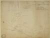
A survey of part of Carah [Carragh] and part of Raheen in the barony of Clane and County Kildare part of the estate of John Mansfield. By J.L. 1813. Table of reference showing tenants names acreage of holdings
Map
Main Creator:
Longfield,
John
, ca. 1775-1833, surveyor
Language:
English
Format:
Map
In collection:
Longfield Map Collection
Published / Created
[1813]
Notes
Some staining at the top of the map. Physical descrip...
Call Number:
Loading...
Located:
Loading...
A map of the glebe lands of Killenaule in the barony of Slievardagh and County of Tipperary belonging to the Chancellor of Christ Church. Surveyed and traced by J.L. 1817. Names of tenants shown & table of reference with tenants names & area of holdings. With additional list 4 January 1833 laid out and possession taken by Sheriff.
Map
Main Creator:
Longfield,
John
, ca. 1775-1833, surveyor
Language:
English
Format:
Map
In collection:
Longfield Map Collection
Published / Created
[1817]
Notes
Physical description: 1 map Geographic Coverage: Bar...
Call Number:
Loading...
Located:
Loading...
A map of the lands of Lismore, the estate of William Carden, and adjoining townlands in the parish of Aghaboe and barony of Clandonagh surveyed to ascertain the bounds of lands between the Duchens of Chandos and William Carden by John Longfield 1809.
Map
Main Creator:
Longfield,
John
, ca. 1775-1833, surveyor
Language:
English
Format:
Map
In collection:
Longfield Map Collection
Published / Created
[1809].
Notes
Physical description: 1 map Geographic Coverage: Par...
Call Number:
Loading...
Located:
Loading...
A map of part of the lands of Kelshamore in the barony of Talbotstown Upper and County of Wicklow the estate of the Rev. Sir Samuel Synge Hutchinson, Bart let to Edward Flynn, Junior. Surveyed by John Longfield 1813. Scale 20 perches to an inch.
Map
Main Creator:
Longfield,
John
, ca. 1775-1833, surveyor
Language:
English
Format:
Map
In collection:
Longfield Map Collection
Published / Created
[1813]
Notes
Physical description: 1 map Geographic Coverage: Bar...
Call Number:
Loading...
Located:
Loading...
A map of three lots of ground situate in the town of Carlingford and County of Louth part of the estate of the Chancellor of Christ Church Dublin. Surveyed by J. Longfield 1805. Scale 50 feet to an inch. Table of reference. Some tenants names shown.
Map
Main Creator:
Longfield,
John
, ca. 1775-1833, surveyor
Language:
English
Format:
Map
In collection:
Longfield Map Collection
Published / Created
[1805]
Notes
A large strip of tape runns through the centre of the...
Call Number:
Loading...
Located:
Loading...
Longitudinal and transverse sections of that part of the river Blackwater adjoining the lands of Mullaghard Rathaldron and Liscartan in the County of Meath. Surveyed by John Long under the direction of William F. Mulvany C.E.
Map
Main Creator:
Longfield,
John
, ca. 1775-1833, surveyor
Language:
English
Format:
Map
In collection:
Longfield Map Collection
Published / Created
[between 1795 and 1833]
Notes
For other sections of the river Blackwater see: MS 21...
Call Number:
Loading...
Located:
Loading...
A survey of the lands of Johnstown in the barony of Duleek Upper and County of Meath. By J.B. August 31 [17]96. Scale 20 perches to an inch. Names of tenants & acreage of holdings shown.
Map
Main Creator:
Brownrigg,
John
, ca. 1748-1838, surveyor
Language:
English
Format:
Map
In collection:
Longfield Map Collection
Published / Created
[August 31 1796]
Notes
Physical description: 1 map Geographic Coverage: Bar...
Call Number:
Loading...
Located:
Loading...
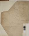
[A Survey of Lands in the townlands of Barberstown, Dunbrow, Huntstown & Pickardstown in the Barony of Coolock and County of Dublin] Surveyed, 1825-1833, 1834-1837 by Wm and J. Longfield. Scale 20 Statute Perches to an Inch
Map
Main Creator:
Longfield,
John
, ca. 1775-1833, surveyor
Language:
English
Format:
Map
In collection:
Longfield Map Collection
Published / Created
[between 1795 and 1833]
Notes
Some damage to the centre of the map which is now in...
Call Number:
Loading...
Located:
Loading...
A survey of the lands called Barn Quarter alias Carrownabinny part of Lisnagross and part of Carrowdangan in the barony of Gallen and County Mayo. Surveyed by order of Frederick French and Lieut Col. Antony Ormsby. By J.L. 1815.
Map
Main Creator:
Longfield,
John
, ca. 1775-1833, surveyor
Language:
English
Format:
Map
In collection:
Longfield Map Collection
Published / Created
[1815]
Notes
Physical description: 1 map Geographic Coverage: Bar...
Call Number:
Loading...
Located:
Loading...
[A map of Part of the Lands of Carpenterstown, being part of the Estate of P. Locke Esq. shewing the adjoining Line of Canal. Partly surveyed and partly copied by Jn. L. 1830. Scale 20 Plantation Perches to an Inch
Map
Main Creator:
Longfield,
John
, ca. 1775-1833, surveyor
Language:
English
Format:
Map
In collection:
Longfield Map Collection
Published / Created
[1830]
Notes
Physical description: 1 map Geographic Coverage: Bar...
Call Number:
Loading...
Located:
Loading...
A survey of part of the Lands of Kinsaly called Sweets farm in the Barony of Coolock & County of Dublin, the Estate of Mrs. Sarah Tighe by John Brownrigg 1794. Scale 10 Perches to an Inch
Map
Main Creator:
Brownrigg,
John
, ca. 1748-1838, surveyor
Language:
English
Format:
Map
In collection:
Longfield Map Collection
Published / Created
[1794]
Notes
Physical description: 1 map Geographic Coverage: Bar...
Call Number:
Loading...
Located:
Loading...
A map of a holding at Hollybrook Park near Clontarf in the County of Dublin let by [illegible] Armstrong Esq. To [illegible] Surveyed by J.L. 1812. Scale 100 Feet to an Inch.
Map
Main Creator:
Longfield,
John
, ca. 1775-1833, surveyor
Language:
English
Format:
Map
In collection:
Longfield Map Collection
Published / Created
[1812]
Notes
Physical description: 1 map Geographic Coverage: Bar...
Call Number:
Loading...
Located:
Loading...
A map of the lands of Harristown in the barony of Moyfenrath Upper and County of Meath part of the estate of the Marquis of Landsdowne. Surveyed by John Longfield. Scale 20 perches to an inch. Names of some tenants, acreage of holdings shown.
Map
Main Creator:
Longfield,
John
, ca. 1775-1833, surveyor
Language:
English
Format:
Map
In collection:
Longfield Map Collection
Published / Created
[between 1795 and 1833]
Notes
Physical description: 1 map Geographic Coverage: Bar...
Call Number:
Loading...
Located:
Loading...
Survey of Lisbaun Feamore and Moyvannan in the barony of Athlone and County of Roscommon the estate of Lieut. Col. F.W. French by John Longfield 1818. Scale 20 perches to an inch. Names of tenants and acreage of holdings shown.
Map
Main Creator:
Longfield,
John
, ca. 1775-1833, surveyor
Language:
English
Format:
Map
In collection:
Longfield Map Collection
Published / Created
[1818]
Notes
Physical description: 1 map Geographic Coverage: Bar...
Call Number:
Loading...
Located:
Loading...
A survey of the Lands of Clonsagh in the Barony of Coolock and County of Dublin, belonging to Messrs. Henry, Mathew & Saml. Bias. By Jn.. Longfield 1815. Scale 10 Perches to an Inch
Map
Main Creator:
Longfield,
John
, ca. 1775-1833, surveyor
Language:
English
Format:
Map
In collection:
Longfield Map Collection
Published / Created
[1815]
Notes
Physical description: 1 map Geographic Coverage: Bar...
Call Number:
Loading...
Located:
Loading...
A map of several parcels of ground call'd the Bell lands of Kilcullen, in the County of Kildare part of the estate of the Prebendaries & Vicars of Christ Church Dublin let to [illegible]. Survey'd by J.L. 1809. Table of reference showing tenants names & area of holdings.
Map
Main Creator:
Longfield,
John
, ca. 1775-1833, surveyor
Language:
English
Format:
Map
In collection:
Longfield Map Collection
Published / Created
[1809]
Notes
Physical description: 1 map Geographic Coverage: Bar...
Call Number:
Loading...
Located:
Loading...
1
2
3
4
5
6
7
8
9
10
11
Next
14
Get RSS Feed
Email this Search
History
Narrow Search
Clear Filter
Digitised
Remove Filters
Clear Filter
Genre: Maps, Manuscript
Format
264
Map
Online Availability
Digitised
Published / Created
From:
To:
Subject
264
Boundaries (Estates)
264
Land tenure
264
Land use surveys
255
Administration of estates
53
History
18
Administration of Estates
Author
186
Longfield, John, ca. 1775-1833, surveyor
46
Brownrigg, John, ca. 1748-1838, surveyor
14
Brownrigg & Co., fl. 1801-1809, surveyors
4
Brownrigg, Longfield and Murray, fl. 1799-ca. 1805, surveyors
4
Scalé, Brownrigg & Sherrard, fl. 1774-1778, surveyors
1
Balfe, M., fl. 1821, surveyor
more ...
1
Bell, John (I and II), fl. 1721-1820
1
Browne, John, fl. 1788-ca. 1807, surveyor
1
Byrne, John, fl. 1789-1828, surveyor
1
Connolly, John, fl. 1826, surveyor
1
Logan, John, fl. 1827-1846, surveyor
1
Longfield, William, fl. 1825-ca. 1870, surveyor
1
Netterville, John, fl. 1747-1768, surveyor
1
O'Brien, John, fl. 1784-1820, surveyor
1
Roe, John, fl. 1793-1824, surveyor
see all ...
less ...
Collections
264
Longfield Map Collection
Language
264
English
Genre
264
Manuscript maps
Maps, Manuscript
53
Early works to 1800
Era
53
18th century
Region
260
Ireland
75
Dublin (Ireland : County)
74
Dublin (County)
57
Meath
57
Meath (Ireland)
46
Kildare (County)
more ...
46
Kildare (Ireland : County)
39
Coolock (Barony)
17
Offaly West (Barony)
16
Castleknock (Barony)
11
Balrothery (Barony)
11
Westmeath
11
Westmeath (Ireland)
11
Wicklow (County)
11
Wicklow (Ireland : County)
10
Roscommon (County)
10
Roscommon (Ireland : County)
9
Duleek Upper (Barony)
9
Laois
9
Laois (Ireland)
7
Moyfenrath Upper (Barony)
7
Ratoath (Barony)
6
Fore (Barony)
6
Kilkenny (County)
6
Kilkenny (Ireland : County)
6
Longford (County)
6
Longford (Ireland : County)
6
Offaly
6
Offaly (Ireland)
5
Dublin (Ireland)
see all ...
less ...
Loading...
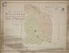
![A survey of Mylerstown in the Islans of Allen barony of Great Connell and County of Kildare the estate of Thomas Hutchinson Smyth By John Brown[r]igg. 1792. Scale 20 perches to an inch. Names of adjoining tenants shown](/IIIF/000310000/000301988/vtls000301988_001.jp2/full/100,/0/default.jpg)


![A survey of part of Carah [Carragh] and part of Raheen in the barony of Clane and County Kildare part of the estate of John Mansfield. By J.L. 1813. Table of reference showing tenants names acreage of holdings](/IIIF/000310000/000301977/vtls000301977_001.jp2/full/100,/0/default.jpg)
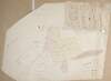


![A survey of the lands of Johnstown in the barony of Duleek Upper and County of Meath. By J.B. August 31 [17]96. Scale 20 perches to an inch. Names of tenants & acreage of holdings shown.](/IIIF/000310000/000301736/vtls000301736_001.jp2/full/100,/0/default.jpg)
![[A Survey of Lands in the townlands of Barberstown, Dunbrow, Huntstown & Pickardstown in the Barony of Coolock and County of Dublin] Surveyed, 1825-1833, 1834-1837 by Wm and J. Longfield. Scale 20 Statute Perches to an Inch](/IIIF/000310000/000301126/vtls000301126_001.jp2/full/100,/0/default.jpg)


![A map of a holding at Hollybrook Park near Clontarf in the County of Dublin let by [illegible] Armstrong Esq. To [illegible] Surveyed by J.L. 1812. Scale 100 Feet to an Inch.](/IIIF/000310000/000301170/vtls000301170_001.jp2/full/100,/0/default.jpg)


![A map of several parcels of ground call'd the Bell lands of Kilcullen, in the County of Kildare part of the estate of the Prebendaries & Vicars of Christ Church Dublin let to [illegible]. Survey'd by J.L. 1809. Table of reference showing tenants names & area of holdings.](/IIIF/000310000/000302001/vtls000302001_001.jp2/full/100,/0/default.jpg)