Showing
1 - 20
results of
70
for search '
Phillips, Thomas, 1635?-1693
'
Skip to content
Toggle navigation
NLI Website
- Catalogue -
English
Gaeilge
Home
Help
Advanced Search
Browse
Orders
Ask a Librarian
Language
English
Gaeilge
All Fields
Title
Author
Subject
Call Number
ISBN/ISSN
Publisher
Coordinates
Search digitised content only
FIND
Author
Phillips, Thomas, 1635?-1693
Results
Showing
1 - 20
results of
70
for search '
Phillips, Thomas, 1635?-1693
'
, query time: 0.05s
List
Grid
Sort
Relevance
Newest First
Oldest First
Call Number
Author
Title
1
2
3
4
Next
4
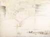
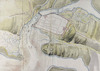
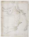
The ground plott of Derry Woragh [Derrywarragh] at the foot of the River Black-Water :
[1685].
5 miles belowe [sic] Charlemont, which is capable of being made strong /
Map
Main Creator:
Phillips
,
Thomas
,
1635
?-
1693
Language:
English
Format:
Map
Published / Created
[1685].
Notes
Exhibits signs of 'pricking', a means by which exact...
Call Number:
Loading...
Located:
Loading...
View image
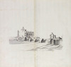
A prospect of Slego [Sligo],
[1685].
Map
Main Creator:
Phillips
,
Thomas
,
1635
?-
1693
Language:
English
Format:
Map
Published / Created
[1685].
Notes
Physical description: 1 sheet : 14 x 37 inches. Geogr...
Call Number:
Loading...
Located:
Loading...
View image
A prospect of Athlone Castle,
[1685].
Map
Main Creator:
Phillips
,
Thomas
,
1635
?-
1693
Language:
English
Format:
Map
Published / Created
[1685].
Notes
"Page 50" inscribed on verso. Executed "By direction...
Call Number:
Loading...
Located:
Loading...
View image
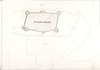
The Citty [sic] of Waterford /
[1685].
Map
Main Creator:
Phillips
,
Thomas
,
1635
?-
1693
Language:
English
Format:
Map
Published / Created
[1685].
Notes
Physical description: 1 sheet : 19 x 29 inches. Geogr...
Call Number:
Loading...
Located:
Loading...
View image
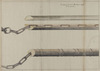
Profile of the redoubt,
[1685].
Map
Main Creator:
Phillips
,
Thomas
,
1635
?-
1693
Language:
English
Format:
Map
Published / Created
[1685].
Notes
"Page 31" inscribed on verso. Executed "By direction...
Call Number:
Loading...
Located:
Loading...
View image
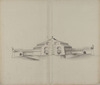
A prospect of Gallway,
[1685].
Map
Main Creator:
Phillips
,
Thomas
,
1635
?-
1693
Language:
English
Format:
Map
Published / Created
[1685].
Notes
"Page 46" inscribed on verso. Executed "By direction...
Call Number:
Loading...
Located:
Loading...
View image
A draught of Culmore Fort with a new designe of fortifying the same /
[1685].
Map
Main Creator:
Phillips
,
Thomas
,
1635
?-
1693
Language:
English
Format:
Map
Published / Created
[1685].
Notes
Exhibits signs of 'pricking', a means by which exact...
Call Number:
Loading...
Located:
Loading...
View image
The ground plaine of Carrick-fergus, with ye strengthening of the castle if thought neccessary,
[1685].
Map
Main Creator:
Phillips
,
Thomas
,
1635
?-
1693
Language:
English
Format:
Map
Published / Created
[1685].
Notes
Originally bound in volume entitled "Rules Orders and...
Call Number:
Loading...
Located:
Loading...
The ground plaine of Galway,
[1685].
Map
Main Creator:
Phillips
,
Thomas
,
1635
?-
1693
Language:
English
Format:
Map
Published / Created
[1685].
Notes
"Page 45" inscribed on verso. Executed "By direction...
Call Number:
Loading...
Located:
Loading...
View image
A draught of the Castle of Dublin at present,
[1685].
Map
Main Creator:
Phillips
,
Thomas
,
1635
?-
1693
Language:
English
Format:
Map
In collection:
Phillips Maps.
Published / Created
[1685].
Notes
Executed "By directions of his Majestie King Charles...
Call Number:
Loading...
Located:
Loading...
View image
A prospect of Gallway /
[1685].
Map
Main Creator:
Phillips
,
Thomas
,
1635
?-
1693
Language:
English
Format:
Map
Published / Created
[1685].
Notes
Physical description: 1 sheet : 14.7 x 37 inches. Geo...
Call Number:
Loading...
Located:
Loading...
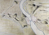
A view of the bay of Bantrey [sic] upon the S:W: part of Ireland /
[1685].
Map
Main Creator:
Phillips
,
Thomas
,
1635
?-
1693
Language:
English
Format:
Map
Published / Created
[1685].
Notes
Inscription at top "Banterey [sic] bay and forte". T...
Call Number:
Loading...
Located:
Loading...
View image
The pass of Athlone,
[1685].
Map
Main Creator:
Phillips
,
Thomas
,
1635
?-
1693
Language:
English
Format:
Map
Published / Created
[1685].
Notes
"Page 49" inscribed on verso. Executed "By direction...
Call Number:
Loading...
Located:
Loading...
View image
The ground plott of Duncannon /
[1685].
Map
Main Creator:
Phillips
,
Thomas
,
1635
?-
1693
Language:
English
Format:
Map
Published / Created
[1685].
Notes
Physical description: 1 sheet : 28 x 39 inches. Geogr...
Call Number:
Loading...
Located:
Loading...
View image
The pass at Athlone /
[1685].
Map
Main Creator:
Phillips
,
Thomas
,
1635
?-
1693
Language:
English
Format:
Map
Published / Created
[1685].
Notes
Exhibits signs of 'pricking', a means by which exact...
Call Number:
Loading...
Located:
Loading...
View image
The ground plaine of Limrick [sic],
[1685].
Map
Main Creator:
Phillips
,
Thomas
,
1635
?-
1693
Language:
English
Format:
Map
Published / Created
[1685].
Notes
"Page 41" inscribed on verso. Executed "By direction...
Call Number:
Loading...
Located:
Loading...
View image
A view of ye Bay of Bantry upon ye So[uth] W[es]t of Ireland,
[1685].
Map
Main Creator:
Phillips
,
Thomas
,
1635
?-
1693
Language:
English
Format:
Map
Published / Created
[1685].
Notes
"Page 40A" inscribed on verso. Executed "By directio...
Call Number:
Loading...
Located:
Loading...
View image
A survey of the mouth of the River of Waterford /
[1685].
Map
Main Creator:
Phillips
,
Thomas
,
1635
?-
1693
Language:
English
Format:
Map
Published / Created
[1685].
Notes
Physical description: 1 sheet : 19 x 16 inches. Geogr...
Call Number:
Loading...
Located:
Loading...
View image
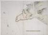
The profile of the cittadell [sic] of Dublin,
[1685].
Map
Main Creator:
Phillips
,
Thomas
,
1635
?-
1693
Language:
English
Format:
Map
Published / Created
[1685].
Notes
"Page 14" inscribed on verso. Executed "By direction...
Call Number:
Loading...
Located:
Loading...
View image
The manner of how boomes ought to be made,
[1685].
Map
Main Creator:
Phillips
,
Thomas
,
1635
?-
1693
Language:
English
Format:
Map
Published / Created
[1685].
Notes
"Page 32" inscribed on verso. Executed "By direction...
Call Number:
Loading...
Located:
Loading...
View image
1
2
3
4
Next
4
Get RSS Feed
Email this Search
History
Narrow Search
Digitised
Format
70
Map
Online Availability
68
Digitised
2
Not Digitised
Published / Created
From:
To:
Subject
51
Maps
51
Maps, Manuscript
41
Fortification
3
Rivers
2
Fortifcation
1
Castles
more ...
1
Fortifications
see all ...
less ...
Author
70
Phillips, Thomas, 1635?-1693
Collections
3
Phillips Maps.
Language
70
English
Genre
51
Early works to 1800
43
Maps
Era
1
18th century
Region
52
Ireland
17
Northern Ireland
6
Cork (Ireland : County)
6
Derry (Northern Ireland)
6
Dublin
6
Shannon River (Ireland)
more ...
5
Kinsale (Ireland)
5
Waterford Harbour (Ireland)
4
Athlone
4
Athlone (Ireland)
4
Belfast Lough (Northern Ireland)
4
Charles Fort (Ireland)
4
Cork Harbour (Ireland)
4
Corrib, River (Ireland)
4
Derrywarragh Island (Northern Ireland)
4
Duncannon (Ireland)
4
Galway (Ireland)
4
Great Island (Ireland)
4
Kinsale
4
Limerick
4
Limerick (Limerick, Ireland)
4
Passage East (Ireland)
3
Bandon River (Ireland)
3
Cork
3
Cork (Ireland)
3
Galway
3
Spike Island (Ireland)
3
Suir River (Ireland)
2
Bantry Bay (Ireland)
2
Belfast
see all ...
less ...
Loading...
![The ground plott of Derry Woragh [Derrywarragh] at the foot of the River Black-Water : 5 miles belowe [sic] Charlemont, which is capable of being made strong /](/IIIF/000280000/000278070/vtls000278070_001.jp2/full/100,/0/default.jpg)
![A prospect of Slego [Sligo],](/IIIF/000280000/000278023/vtls000278023_001.jp2/full/100,/0/default.jpg)
![The Citty [sic] of Waterford /](/IIIF/000280000/000277858/vtls000277858_001.jp2/full/100,/0/default.jpg)


![A view of the bay of Bantrey [sic] upon the S:W: part of Ireland /](/IIIF/000280000/000277992/vtls000277992_001.jp2/full/100,/0/default.jpg)

![The ground plaine of Limrick [sic],](http://www.nli.ie/digital/thumbs/vtls000277582.jpg)
![A view of ye Bay of Bantry upon ye So[uth] W[es]t of Ireland,](http://www.nli.ie/digital/thumbs/vtls000277580.jpg)
![The profile of the cittadell [sic] of Dublin,](http://www.nli.ie/digital/thumbs/vtls000280438.jpg)