Showing
181 - 200
results of
526
for search '
Will, John.
'
Skip to content
Toggle navigation
NLI Website
- Catalogue -
English
Gaeilge
Home
Help
Advanced Search
Browse
Orders
Ask a Librarian
Language
English
Gaeilge
All Fields
Title
Author
Subject
Call Number
ISBN/ISSN
Publisher
Coordinates
Search digitised content only
FIND
Author
Will, John.
Results
Showing
181 - 200
results of
526
for search '
Will, John.
'
, query time: 0.09s
List
Grid
Sort
Relevance
Newest First
Oldest First
Call Number
Author
Title
1
Previous
5
6
7
8
9
10
11
12
13
14
15
Next
27
A map of a piece of ground on the east side of St. Michaels Lane, part of the estate of the Dean & Chapter of Christ Church let to [illegible] Grant Esq. Surveyed by John Longfield 1814. Names of tenants shown on properties
Map
Main Creator:
Longfield,
John
, ca. 1775-1833, surveyor
Language:
English
Format:
Map
In collection:
Longfield Map Collection
Published / Created
[1814]
Notes
Physical description: 1 map Geographic Coverage: Dub...
Call Number:
Loading...
Located:
Loading...
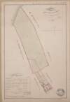
A survey of pt. of the Lands of Flemingstown in the Co of Dublin pt. of the Estate of the Marquis of Lansdown let to M. Dillon [Ths.] in April by John Longfield 1832.
Map
Main Creator:
Longfield,
John
, ca. 1775-1833, surveyor
Language:
English
Format:
Map
In collection:
Longfield Map Collection
Published / Created
[April 1832]
Notes
In poor condition with a tear across the top of the m...
Call Number:
Loading...
Located:
Loading...
A map of several lots of ground in the town of Mountmellick part of the Marquis of Drogheda estate. Surveyed by John Longfield, 1819. Scale 4 perches to an inch. Table of reference showing tenants names & area of holdings.
Map
Main Creator:
Longfield,
John
, ca. 1775-1833, surveyor
Language:
English
Format:
Map
In collection:
Longfield Map Collection
Published / Created
[1819]
Notes
Physical description: 1 map Geographic Coverage: Bar...
Call Number:
Loading...
Located:
Loading...
A survey of lands at Windgate in the barony of Rathdown and County of Wicklow done for the Rev. Thomas Brownrigg. By John Longfield. 1809. Scale 10 perches to an inch. Table of reference showing tenants and acreage of holdings.
Map
Main Creator:
Longfield,
John
, ca. 1775-1833, surveyor
Language:
English
Format:
Map
In collection:
Longfield Map Collection
Published / Created
[1809]
Notes
Physical description: 1 map Geographic Coverage: Bar...
Call Number:
Loading...
Located:
Loading...
A map of a piece of ground [now a plantation] adjoining the concerns of John Cassidy in Monasterevin, the estate of Charles Marquis of Drogheda. Surveyed September 1806. By J.L. Scale 42 feet to an inch.
Map
Main Creator:
Longfield,
John
, ca. 1775-1833, surveyor
Language:
English
Format:
Map
In collection:
Longfield Map Collection
Published / Created
[1806]
Notes
Physical description: 1 map Geographic Coverage: Bar...
Call Number:
Loading...
Located:
Loading...
Longitudinal and transverse sections of that part of the river Blackwater adjoining the lands of Mullaghard Rathaldron and Liscartan in the County of Meath. Surveyed by John Long under the direction of William F. Mulvany C.E.
Map
Main Creator:
Longfield,
John
, ca. 1775-1833, surveyor
Language:
English
Format:
Map
In collection:
Longfield Map Collection
Published / Created
[between 1795 and 1833]
Notes
For other sections of the river Blackwater see MS 21...
Call Number:
Loading...
Located:
Loading...
A map of two Holdings in the street of Tallaght in the County of Dublin belonging to Mr. Anthy. Cleval by J. Brownrigg 1797. Scale Eight Perches to an Inch
Map
Main Creator:
Brownrigg,
John
, ca. 1748-1838, surveyor
Language:
English
Format:
Map
In collection:
Longfield Map Collection
Published / Created
[1797]
Notes
Physical description: 1 map Geographic Coverage: Bar...
Call Number:
Loading...
Located:
Loading...
A map of Part of the Lands of Rathfarnham Surveyed for Mr. Moore by J.L. 1812. Scale 10 Perches to an Inch
Map
Main Creator:
Longfield,
John
, ca. 1775-1833, surveyor
Language:
English
Format:
Map
In collection:
Longfield Map Collection
Published / Created
[1812]
Notes
Physical description: 1 map Geographic Coverage: Bar...
Call Number:
Loading...
Located:
Loading...
A map of a holding on the north side of Summer Hill in the City of Dublin the propety of Mr. Wood. Surveyed by J.B. 1792. Names of adjoining tenants shown
Map
Main Creator:
Brownrigg,
John
, ca. 1748-1838, surveyor
Language:
English
Format:
Map
In collection:
Longfield Map Collection
Published / Created
[1792]
Notes
Physical description: 1 map Geographic Coverage: Dub...
Call Number:
Loading...
Located:
Loading...
A survey of the lands of Castlekeely in the barony of Clane and County Kildare the estate of John Mansfield. Surveyed by J.L. 1816. Names of tenants shown on some holdings
Map
Main Creator:
Longfield,
John
, ca. 1775-1833, surveyor
Language:
English
Format:
Map
In collection:
Longfield Map Collection
Published / Created
[1816]
Notes
Some staining around the sides of the map. Physical d...
Call Number:
Loading...
Located:
Loading...
A map of the bog of Cloonegad [Clonegath] in the County of Kildare shewing the situation and extent of the several turf banks occupied by sundry tenants of the most noble Charles Marquis of Drogheda. By J.L. 1811.
Map
Main Creator:
Longfield,
John
, ca. 1775-1833, surveyor
Language:
English
Format:
Map
In collection:
Longfield Map Collection
Published / Created
[1811]
Notes
Physical description: 1 map Geographic Coverage: Bar...
Call Number:
Loading...
Located:
Loading...
A survey of Part of Blanchardstown in the Barony of Castleknock and County of Dublin. The Estate of Peter Locke Esq. Let to Mr. Baird By J.L. 1829. Scale 20 Perches to an Inch
Map
Main Creator:
Longfield,
John
, ca. 1775-1833, surveyor
Language:
English
Format:
Map
In collection:
Longfield Map Collection
Published / Created
[1829]
Notes
Physical description: 1 map Geographic Coverage: Bar...
Call Number:
Loading...
Located:
Loading...
A survey of the Lands of Loughanstown and Brennanstown in the County of Dublin part of the Estate of the Dean of Christ Church by J.L. 1821. Scale 20 Perches to an Inch.
Map
Main Creator:
Longfield,
John
, ca. 1775-1833, surveyor
Language:
English
Format:
Map
In collection:
Longfield Map Collection
Published / Created
[1821]
Notes
Physical description: 1 map Geographic Coverage: Bar...
Call Number:
Loading...
Located:
Loading...
A map of part of the Lands of Rathfarnham, Barony of Nethercross {recte & Barony of Rathdown] and County of Dublin. Surveyed by J.L.
Map
Main Creator:
Longfield,
John
, ca. 1775-1833, surveyor
Language:
English
Format:
Map
In collection:
Longfield Map Collection
Published / Created
[between 1795 and 1833]
Notes
Physical description: 1 map Geographic Coverage: Bar...
Call Number:
Loading...
Located:
Loading...
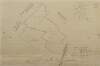
Section of boundary stream between Ballybin and Cookstown in the County of Meath showing the proposed new sinking of same to drain the farms of Messrs. Rooney, Moran, Babbett and Kconan done by order of Robert Franks March 183[1] By J.L. Longitudinal scale 20 perches to an inch. Height scale 20 feet to an inch.
Map
Main Creator:
Longfield,
John
, ca. 1775-1833, surveyor
Language:
English
Format:
Map
In collection:
Longfield Map Collection
Published / Created
[March 1831]
Notes
Physical description: 1 map Geographic Coverage: Bar...
Call Number:
Loading...
Located:
Loading...
A survey of a holding in Fontstown Marquis of Drogheda estate by J.L. 1826. Tenants names & acreages shown.
Map
Main Creator:
Longfield,
John
, ca. 1775-1833, surveyor
Language:
English
Format:
Map
In collection:
Longfield Map Collection
Published / Created
[1826]
Notes
To view the inset see MS 21 F. 36 / (125). Physical d...
Call Number:
Loading...
Located:
Loading...
A survey of part of the lands of Shanahoe and Killeany in the barony of Maryborough West and Queen's [Leix] County purchased by H.H. Bawne Surveyed by J.L. 1815. Names of tenants & acreage of holdings shown.
Map
Main Creator:
Longfield,
John
, ca. 1775-1833, surveyor
Language:
English
Format:
Map
In collection:
Longfield Map Collection
Published / Created
[1815]
Notes
Physical description: 1 map Geographic Coverage: Cou...
Call Number:
Loading...
Located:
Loading...
A map of part of the lands of Cloghernagh [Patrickstown?] in the barony of Demifore and County Meath part of the estate of Lady Piers Marley let to Bryan Brady. By J.L. 180[1?].
Map
Main Creator:
Longfield,
John
, ca. 1775-1833, surveyor
Language:
English
Format:
Map
In collection:
Longfield Map Collection
Published / Created
[1801]
Notes
Physical description: 1 map Geographic Coverage: Bar...
Call Number:
Loading...
Located:
Loading...
A survey of Jordans Lands in several Divisions in the Town & Lands of Crumlin and County of Dublin done for Wm. Thomas Esq., Miss Sarah Cuthbert, Widow and the Reverend John Grave Clark. By John Brownrigg 1784. Scale Ten Perches to an Inch
Map
Main Creator:
Brownrigg,
John
, ca. 1748-1838, surveyor
Language:
English
Format:
Map
In collection:
Longfield Map Collection
Published / Created
[1784]
Notes
Physical description: 1 map Geographic Coverage: Bar...
Call Number:
Loading...
Located:
Loading...
A survey of part of Mrs. Maynes property near Blackrock subdivided in lots for building ... [By] John Molloy 1836. Laid to a scale of Perches
Map
Main Creator:
Molloy,
John
, fl. 1809-1839, surveyor
Language:
English
Format:
Map
In collection:
Longfield Map Collection
Published / Created
[1836]
Notes
Physical description: 1 map Geographic Coverage: Bar...
Call Number:
Loading...
Located:
Loading...
1
Previous
5
6
7
8
9
10
11
12
13
14
15
Next
27
Get RSS Feed
Email this Search
History
Narrow Search
Digitised
Remove Filters
Clear Filter
Genre: Maps, Manuscript
Clear Filter
Subject: Boundaries (Estates)
Format
526
Map
Online Availability
264
Digitised
262
Not Digitised
Published / Created
From:
To:
Subject
Boundaries (Estates)
526
Land tenure
526
Land use surveys
516
Administration of estates
126
History
19
Administration of Estates
Author
335
Longfield, John, ca. 1775-1833, surveyor
112
Brownrigg, John, ca. 1748-1838, surveyor
42
Brownrigg & Co., fl. 1801-1809, surveyors
7
Brownrigg, Longfield and Murray, fl. 1799-ca. 1805, surveyors
6
Longfield, William, fl. 1825-ca. 1870, surveyor
4
Scalé, Brownrigg & Sherrard, fl. 1774-1778, surveyors
more ...
3
Roe, John, fl. 1793-1824, surveyor
2
Brownrigg & Sherrard, fl. 1777-1778, surveyors
2
Byrne, John, fl. 1789-1828, surveyor
2
Moynahan, John, fl. 1736-1764, surveyor
1
Balfe, M., fl. 1821, surveyor
1
Battersby, John, fl. 1778, surveyor
1
Bell, John (I and II), fl. 1721-1820
1
Browne, John, fl. 1788-ca. 1807, surveyor
1
Connolly, John, fl. 1826, surveyor
1
Kelly, John, fl. 1820-1852, surveyor
1
Logan, John, fl. 1827-1846, surveyor
1
Molloy, John, fl. 1809-1839, surveyor
1
Netterville, John, fl. 1747-1768, surveyor
1
O'Brien, John, fl. 1784-1820, surveyor
1
Wright, John, fl. 1759-1775, surveyor
see all ...
less ...
Collections
526
Longfield Map Collection
Language
526
English
Genre
526
Manuscript maps
Maps, Manuscript
126
Early works to 1800
Era
126
18th century
Region
522
Ireland
321
Dublin (Ireland : County)
320
Dublin (County)
130
Dublin (Ireland)
127
Dublin
58
Meath
more ...
58
Meath (Ireland)
57
Rathdown (Barony)
49
Kildare (County)
49
Kildare (Ireland : County)
40
Coolock (Barony)
27
Uppercross (Barony)
21
Newcastle (Barony)
18
Offaly West (Barony)
17
Dublin (Barony)
16
Castleknock (Barony)
16
Dublin City (Barony)
16
Nethercross (Barony)
13
Wicklow (County)
13
Wicklow (Ireland : County)
12
Westmeath
12
Westmeath (Ireland)
11
Balrothery (Barony)
10
Roscommon (County)
10
Roscommon (Ireland : County)
9
Duleek Upper (Barony)
9
Laois
9
Laois (Ireland)
8
Tipperary (County)
8
Tipperary (Ireland : County)
see all ...
less ...
Loading...
![A survey of pt. of the Lands of Flemingstown in the Co of Dublin pt. of the Estate of the Marquis of Lansdown let to M. Dillon [Ths.] in April by John Longfield 1832.](/IIIF/000310000/000302275/vtls000302275_001.jp2/full/100,/0/default.jpg)

![A map of a piece of ground [now a plantation] adjoining the concerns of John Cassidy in Monasterevin, the estate of Charles Marquis of Drogheda. Surveyed September 1806. By J.L. Scale 42 feet to an inch.](/IIIF/000310000/000302176/vtls000302176_001.jp2/full/100,/0/default.jpg)

![A map of the bog of Cloonegad [Clonegath] in the County of Kildare shewing the situation and extent of the several turf banks occupied by sundry tenants of the most noble Charles Marquis of Drogheda. By J.L. 1811.](/IIIF/000310000/000302206/vtls000302206_001.jp2/full/100,/0/default.jpg)
![Section of boundary stream between Ballybin and Cookstown in the County of Meath showing the proposed new sinking of same to drain the farms of Messrs. Rooney, Moran, Babbett and Kconan done by order of Robert Franks March 183[1] By J.L. Longitudinal scale 20 perches to an inch. Height scale 20 feet to an inch.](/IIIF/000310000/000301845/vtls000301845_001.jp2/full/100,/0/default.jpg)
![A survey of part of the lands of Shanahoe and Killeany in the barony of Maryborough West and Queen's [Leix] County purchased by H.H. Bawne Surveyed by J.L. 1815. Names of tenants & acreage of holdings shown.](/IIIF/000310000/000302379/vtls000302379_001.jp2/full/100,/0/default.jpg)
![A map of part of the lands of Cloghernagh [Patrickstown?] in the barony of Demifore and County Meath part of the estate of Lady Piers Marley let to Bryan Brady. By J.L. 180[1?].](/IIIF/000310000/000301764/vtls000301764_001.jp2/full/100,/0/default.jpg)