Showing
61 - 80
results of
258
for search '
Will, John.
'
Skip to content
Toggle navigation
NLI Website
- Catalogue -
English
Gaeilge
Home
Help
Advanced Search
Browse
Orders
Ask a Librarian
Language
English
Gaeilge
All Fields
Title
Author
Subject
Call Number
ISBN/ISSN
Publisher
Coordinates
Search digitised content only
FIND
Author
Will, John.
Results
Showing
61 - 80
results of
258
for search '
Will, John.
'
, query time: 0.05s
List
Grid
Sort
Relevance
Newest First
Oldest First
Call Number
Author
Title
1
Previous
1
2
3
4
5
6
7
8
9
10
11
Next
13
A survey of the town of Monasterevin done with a view to shew the advantage & improvement of changing the bridge from its present site so as to range with the main entrance from Dublin. By John Longfield, 1807. Scale 100 feet to an inch. Names of some tenants shown on properties.
Map
Main Creator:
Longfield,
John
, ca. 1775-1833, surveyor
Language:
English
Format:
Map
In collection:
Longfield Map Collection
Published / Created
[1807]
Notes
Physical description: 1 map Geographic Coverage: Bar...
Call Number:
Loading...
Located:
Loading...
A survey of the Demense of Thorn Hill in the Parish of Clontarf & Co. of Dublin, belonging to Mrs. Bull, by J.L. 1816. Scale 10 Perches to an Inch
Map
Main Creator:
Longfield,
John
, ca. 1775-1833, surveyor
Language:
English
Format:
Map
In collection:
Longfield Map Collection
Published / Created
[1816]
Notes
Physical description: 1 map Geographic Coverage: Par...
Call Number:
Loading...
Located:
Loading...
A map of part of Peafield in the Barony of Coolock & County of Dublin, the Estate of [illegible] Bever Esq. Survey'd by John Brownrigg 1795. Scale 20 Perches to an Inch
Map
Main Creator:
Brownrigg,
John
, ca. 1748-1838, surveyor
Language:
English
Format:
Map
In collection:
Longfield Map Collection
Published / Created
[1795]
Notes
Physical description: 1 map Geographic Coverage: Bar...
Call Number:
Loading...
Located:
Loading...
A survey of part of the lands of Ballynabarny in the barony of Newcastle and County of Wicklow. By J.L. 1831. Scale 20 perches to an inch.
Map
Main Creator:
Longfield,
John
, ca. 1775-1833, surveyor
Language:
English
Format:
Map
In collection:
Longfield Map Collection
Published / Created
[1831]
Notes
Physical description: 1 map Geographic Coverage: Bar...
Call Number:
Loading...
Located:
Loading...
A survey of part of the Lands of Blanchardstown in the County of Dublin - Parish & Barony of Castleknock, the Estate of Peter Locke Esq. by John Longfield 1830. Scale 10 Perches to an Inch
Map
Main Creator:
Longfield,
John
, ca. 1775-1833, surveyor
Language:
English
Format:
Map
In collection:
Longfield Map Collection
Published / Created
[1830]
Notes
Physical description: 1 map Geographic Coverage: Par...
Call Number:
Loading...
Located:
Loading...
A map of part of the Lands of Ashtown, near the 11th lock of the Royal Canal in the Co Dublin. Surveyed by J.L. Scale 100 Feet to an Inch
Map
Main Creator:
Longfield,
John
, ca. 1775-1833, surveyor
Language:
English
Format:
Map
In collection:
Longfield Map Collection
Published / Created
[between 1795 and 1833]
Notes
Physical description: 1 map Geographic Coverage: Bar...
Call Number:
Loading...
Located:
Loading...
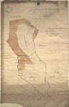
A map of the lands of Oughill [Oghil] in the barony of Ophaley [Offaly] west and County of Kildare the estate of the most noble Charles Marquis of Drogheda. Surveyed by John Longfield 1816. Names of tenants and acreage of holdings shown.
Map
Main Creator:
Longfield,
John
, ca. 1775-1833, surveyor
Language:
English
Format:
Map
In collection:
Longfield Map Collection
Published / Created
[1816]
Notes
Physical description: 1 map Geographic Coverage: Bar...
Call Number:
Loading...
Located:
Loading...
A survey of the Grange of Balscaddin in the Barony of Balrothery and County of Dublin belongg. to the Dean & Chapter of Christ Church by J.B. -[?]. March 7 1795
Map
Main Creator:
Brownrigg,
John
, ca. 1748-1838, surveyor
Language:
English
Format:
Map
In collection:
Longfield Map Collection
Published / Created
[March 07 1795]
Notes
Physical description: 1 map Geographic Coverage: Bar...
Call Number:
Loading...
Located:
Loading...
A map of a proposed line to be laid out as an equal give and take straight boundary between Hodgestown the estate of the Rt. Hon. the Earl of Longford, and Higginstown the estate of George Nugent. Surveyed by John Brownrigg. 1796. Scale 20 perches to an inch.
Map
Main Creator:
Brownrigg,
John
, ca. 1748-1838, surveyor
Language:
English
Format:
Map
In collection:
Longfield Map Collection
Published / Created
[1796]
Notes
Physical description: 1 map Geographic Coverage: Bar...
Call Number:
Loading...
Located:
Loading...
A map of Ballymore in the barony of Granard and County of Longford the joint estate of the Honable. George F. Lyttleton and William F. Greville by John Brownrigg 1792. Scale 20 perches to an inch. Table of reference showing denominations & acreage.
Map
Main Creator:
Brownrigg,
John
, ca. 1748-1838, surveyor
Language:
English
Format:
Map
In collection:
Longfield Map Collection
Published / Created
[1792]
Notes
Some staining on the right-hand side and bottom of th...
Call Number:
Loading...
Located:
Loading...
A map of the bog of Clongill in the barony of Morgallion Co. Meath as it was this day divided between Joseph Stock Lord Bishop of Killala, Rev. H. Palmer and John Gerrard. By John Longfield 21st May 1805. Signed by the parties.
Map
Main Creator:
Longfield,
John
, ca. 1775-1833, surveyor
Language:
English
Format:
Map
In collection:
Longfield Map Collection
Published / Created
[May 21 1805]
Notes
Physical description: 1 map Geographic Coverage: Bar...
Call Number:
Loading...
Located:
Loading...
A map of Rathcastle and Rowlandstown in the barony of Rathconrath and County Westmeath the estate of Thomas Bannon. Surveyed by J.L. 1809. Table of reference showing tenants and acreage of holdings. Scale 10 perches to an inch.
Map
Main Creator:
Longfield,
John
, ca. 1775-1833, surveyor
Language:
English
Format:
Map
In collection:
Longfield Map Collection
Published / Created
[1809]
Notes
Physical description: 1 map Geographic Coverage: Bar...
Call Number:
Loading...
Located:
Loading...
A map of Ballintruer More in the barony of Talbotstown Upper and County of Wicklow. By John Longfield 1813. Scale 20 perches to an inch.
Map
Main Creator:
Longfield,
John
, ca. 1775-1833, surveyor
Language:
English
Format:
Map
In collection:
Longfield Map Collection
Published / Created
[1813]
Notes
Physical description: 1 map Geographic Coverage: Bar...
Call Number:
Loading...
Located:
Loading...
A survey of the lands of Ballinlig and Cornamucklagh [near Clonard] in the barony of Carbury and County of Kildare part of the estate of Lady Jane Loftus. By J. Longfield. June 1819. Some tenants names shown on holdings
Map
Main Creator:
Longfield,
John
, ca. 1775-1833, surveyor
Language:
English
Format:
Map
In collection:
Longfield Map Collection
Published / Created
[June 1819]
Notes
Damaged, with some tears and creases. Some staining i...
Call Number:
Loading...
Located:
Loading...
A survey of the lands & bogs of Cloncarlon [Cloncarlin] near Monasterevin in the County of Kildare occupied by John Cassidy. By J.L. 1815. Scale 16 perches to an inch. Table of reference showing area of profitable and cutaway bog.
Map
Main Creator:
Longfield,
John
, ca. 1775-1833, surveyor
Language:
English
Format:
Map
In collection:
Longfield Map Collection
Published / Created
[1815]
Notes
Physical description: 1 map Geographic Coverage: Bar...
Call Number:
Loading...
Located:
Loading...
A survey of the Lands of Doonane and Drummaghmartin, in the Barony of Tulla & Co. Clare, let to Henry Molony Esq., the Estate of Tottenham Esq. by J.L. 1815
Map
Main Creator:
Longfield,
John
, ca. 1775-1833, surveyor
Language:
English
Format:
Map
In collection:
Longfield Map Collection
Published / Created
[1815]
Notes
Physical description: 1 map Geographic Coverage: Bar...
Call Number:
Loading...
Located:
Loading...
A map of Mylarstown [Mylerstown] & Killiagh [Killeagh] in the Island of Allen and County of Kildare the estate of Thomas Smyth held by William Wyly, Joseph & Aaron Mickle. Surveyed February 1765 by John Nettervile. Scale 40 perches to an inch. Table of reference showing tenants & acreage of holdings.
Map
Main Creator:
Netterville,
John
, fl. 1747-1768, surveyor
Language:
English
Format:
Map
In collection:
Longfield Map Collection
Published / Created
[February 1765]
Notes
Physical description: 1 map Geographic Coverage: Bar...
Call Number:
Loading...
Located:
Loading...
A survey of part of the estate of John Pollock situate in the barony of Lower Kells and County of Meath [at Tullyatten...] By J.L. 1805. Names of tenants & acreage of holdings shown.
Map
Main Creator:
Longfield,
John
, ca. 1775-1833, surveyor
Language:
English
Format:
Map
In collection:
Longfield Map Collection
Published / Created
[1805]
Notes
Physical description: 1 map Geographic Coverage: Bar...
Call Number:
Loading...
Located:
Loading...
A map of the Grange of Balscaddin in the Barony of Balrothery & County of Dublin - the Estate of the Dean of Christ Church. Surveyed by J.L. 1823.
Map
Main Creator:
Longfield,
John
, ca. 1775-1833, surveyor
Language:
English
Format:
Map
In collection:
Longfield Map Collection
Published / Created
[1823]
Notes
Physical description: 1 map Geographic Coverage: Bar...
Call Number:
Loading...
Located:
Loading...
A Survey of the Lands of Edengully alias Edendewgallen in the Barony of Cloonkee & Co. Cavan - the Estate of Mr. Smyth, by J.L. 1816
Map
Main Creator:
Longfield,
John
, ca. 1775-1833, surveyor
Language:
English
Format:
Map
In collection:
Longfield Map Collection
Published / Created
[1816]
Notes
Physical description: 1 map Geographic Coverage: Par...
Call Number:
Loading...
Located:
Loading...
1
Previous
1
2
3
4
5
6
7
8
9
10
11
Next
13
Get RSS Feed
Email this Search
History
Narrow Search
Clear Filter
Digitised
Remove Filters
Clear Filter
Subject: Administration of estates
Format
255
Map
2
Book
1
Manuscript
Online Availability
Digitised
Published / Created
From:
To:
Subject
Administration of estates
256
Land tenure
255
Boundaries (Estates)
255
Land use surveys
56
History
9
Administration of Estates
more ...
2
Social conditions
1
Engineers
1
Estates
1
History, Local
1
Law and legislation
1
Politics and government
see all ...
less ...
Author
177
Longfield, John, ca. 1775-1833, surveyor
46
Brownrigg, John, ca. 1748-1838, surveyor
14
Brownrigg & Co., fl. 1801-1809, surveyors
4
Brownrigg, Longfield and Murray, fl. 1799-ca. 1805, surveyors
4
Scalé, Brownrigg & Sherrard, fl. 1774-1778, surveyors
1
Balfe, M., fl. 1821, surveyor
more ...
1
Bell, John (I and II), fl. 1721-1820
1
Browne, John, fl. 1788-ca. 1807, surveyor
1
Byrne, John, fl. 1789-1828, surveyor
1
Connolly, John, fl. 1826, surveyor
1
Drennan, John T.
1
John Barrett & Sons (Firm)
1
Logan, John, fl. 1827-1846, surveyor
1
Longfield, William, fl. 1825-ca. 1870, surveyor
1
Mahon, Denis, 1786 or 7-1847
1
Netterville, John, fl. 1747-1768, surveyor
1
O'Brien, John, fl. 1784-1820, surveyor
1
Roe, John, fl. 1793-1824, surveyor
see all ...
less ...
Collections
255
Longfield Map Collection
1
Pakenham-Mahon Additional Papers, 1654-1895.
Language
258
English
Genre
255
Manuscript maps
255
Maps, Manuscript
53
Early works to 1800
1
Correspondence
Era
54
18th century
1
17th century
1
1910-1921
1
19th century
1
20th century
Region
254
Ireland
75
Dublin (Ireland : County)
74
Dublin (County)
48
Meath
48
Meath (Ireland)
46
Kildare (County)
more ...
46
Kildare (Ireland : County)
39
Coolock (Barony)
17
Offaly West (Barony)
16
Castleknock (Barony)
11
Balrothery (Barony)
11
Roscommon (County)
11
Roscommon (Ireland : County)
11
Westmeath
11
Westmeath (Ireland)
11
Wicklow (County)
11
Wicklow (Ireland : County)
9
Duleek Upper (Barony)
9
Laois
9
Laois (Ireland)
7
Moyfenrath Upper (Barony)
7
Ratoath (Barony)
6
Fore (Barony)
6
Kilkenny (County)
6
Kilkenny (Ireland : County)
6
Longford (County)
6
Longford (Ireland : County)
6
Offaly
6
Offaly (Ireland)
5
Dublin (Ireland)
see all ...
less ...
Loading...
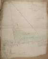

![A map of part of Peafield in the Barony of Coolock & County of Dublin, the Estate of [illegible] Bever Esq. Survey'd by John Brownrigg 1795. Scale 20 Perches to an Inch](/IIIF/000310000/000301182/vtls000301182_001.jp2/full/100,/0/default.jpg)


![A map of the lands of Oughill [Oghil] in the barony of Ophaley [Offaly] west and County of Kildare the estate of the most noble Charles Marquis of Drogheda. Surveyed by John Longfield 1816. Names of tenants and acreage of holdings shown.](/IIIF/000310000/000302067/vtls000302067_001.jp2/full/100,/0/default.jpg)
![A survey of the Grange of Balscaddin in the Barony of Balrothery and County of Dublin belongg. to the Dean & Chapter of Christ Church by J.B. -[?]. March 7 1795](/IIIF/000310000/000302261/vtls000302261_001.jp2/full/100,/0/default.jpg)


![A survey of the lands of Ballinlig and Cornamucklagh [near Clonard] in the barony of Carbury and County of Kildare part of the estate of Lady Jane Loftus. By J. Longfield. June 1819. Some tenants names shown on holdings](/IIIF/000310000/000301969/vtls000301969_001.jp2/full/100,/0/default.jpg)
![A survey of the lands & bogs of Cloncarlon [Cloncarlin] near Monasterevin in the County of Kildare occupied by John Cassidy. By J.L. 1815. Scale 16 perches to an inch. Table of reference showing area of profitable and cutaway bog.](/IIIF/000310000/000302062/vtls000302062_001.jp2/full/100,/0/default.jpg)
![A map of Mylarstown [Mylerstown] & Killiagh [Killeagh] in the Island of Allen and County of Kildare the estate of Thomas Smyth held by William Wyly, Joseph & Aaron Mickle. Surveyed February 1765 by John Nettervile. Scale 40 perches to an inch. Table of reference showing tenants & acreage of holdings.](/IIIF/000310000/000302034/vtls000302034_001.jp2/full/100,/0/default.jpg)
![A survey of part of the estate of John Pollock situate in the barony of Lower Kells and County of Meath [at Tullyatten...] By J.L. 1805. Names of tenants & acreage of holdings shown.](/IIIF/000310000/000301771/vtls000301771_001.jp2/full/100,/0/default.jpg)

