Showing
61 - 80
results of
264
for search '
Will, John.
'
Skip to content
Toggle navigation
NLI Website
- Catalogue -
English
Gaeilge
Home
Help
Advanced Search
Browse
Orders
Ask a Librarian
Language
English
Gaeilge
All Fields
Title
Author
Subject
Call Number
ISBN/ISSN
Publisher
Coordinates
Search digitised content only
FIND
Author
Will, John.
Results
Showing
61 - 80
results of
264
for search '
Will, John.
'
, query time: 0.04s
List
Grid
Sort
Relevance
Newest First
Oldest First
Call Number
Author
Title
1
Previous
1
2
3
4
5
6
7
8
9
10
11
Next
14
A survey of Carn in the barony of Fore and County of Westmeath part of the estate of the Rt. Hon. the Earl of Longford. By J.B. December 1798. Scale 20 perches to an inch.
Map
Main Creator:
Brownrigg,
John
, ca. 1748-1838, surveyor
Language:
English
Format:
Map
In collection:
Longfield Map Collection
Published / Created
[December 1798]
Notes
Physical description: 1 map Geographic Coverage: Bar...
Call Number:
Loading...
Located:
Loading...
A map of several parcels of Land commonly call'd Fosters Farm in the Parish of Glasnevin & County of Dublin, part of the Estate of the Rt. Honble. and Rt. Revd. The Dean of Christ Church - let to John Wm. Bayley Esq. Surveyed by John Longfield 1807. Scale 16 Perches to an Inch
Map
Main Creator:
Longfield,
John
, ca. 1775-1833, surveyor
Language:
English
Format:
Map
In collection:
Longfield Map Collection
Published / Created
[1807]
Notes
Physical description: 1 map Geographic Coverage: Par...
Call Number:
Loading...
Located:
Loading...
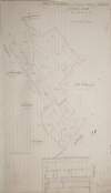
A survey of Cloughan [Cloghan] in the barony of Upper Duleek County of Dublin the estate of General Hawkshaw. Surveyed by John Longfield. 1816. Scale 20 perches to an inch. Names of tenants shown on holdings and in table of reference with acreage of holdings.
Map
Main Creator:
Longfield,
John
, ca. 1775-1833, surveyor
Language:
English
Format:
Map
In collection:
Longfield Map Collection
Published / Created
[1816]
Notes
There is a large crease running through the map. Phys...
Call Number:
Loading...
Located:
Loading...
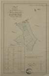
A map of Fearmoor [Fearmore] in the Barony of Offaly West and County of Kildare the estate of the Marquis of Drogheda. By John Longfield 1815. Scale 20 perches to an inch. Names of tenants and acreage of holdings shown.
Map
Main Creator:
Longfield,
John
, ca. 1775-1833, surveyor
Language:
English
Format:
Map
In collection:
Longfield Map Collection
Published / Created
[1815]
Notes
Inset map: "A map of the lands of Grangecoor in the B...
Call Number:
Loading...
Located:
Loading...
A survey of Knocknacahera in the Barony of Muskerry & County Cork - The property of Lord Midleton, Revd. Edward J. Hudson and - Denahy Esq. By J.L. 1830
Map
Main Creator:
Longfield,
John
, ca. 1775-1833, surveyor
Language:
English
Format:
Map
In collection:
Longfield Map Collection
Published / Created
[1830]
Notes
Physical description: 1 map Geographic Coverage: Bar...
Call Number:
Loading...
Located:
Loading...
A survey of part of the lands of Tonacoolin [Tonacooleen] situate in the Barony of Clare and County Galway the estate of Wm Murphy. By John Longfield 1812. Table of reference showing tenants names & acreage
Map
Main Creator:
Longfield,
John
, ca. 1775-1833, surveyor
Language:
English
Format:
Map
In collection:
Longfield Map Collection
Published / Created
[1812]
Notes
Physical description: 1 map Geographic Coverage: Bar...
Call Number:
Loading...
Located:
Loading...
A map of a lot of ground on the north side of Sheriff Street in the City of Dublin done for James Williams by John Longfield 1815. Adjoining names shown
Map
Main Creator:
Longfield,
John
, ca. 1775-1833, surveyor
Language:
English
Format:
Map
In collection:
Longfield Map Collection
Published / Created
[1815]
Notes
Physical description: 1 map Geographic Coverage: Dub...
Call Number:
Loading...
Located:
Loading...
A survey of Lisnolan in the parish of Balla and County of Mayo. The estate of Frederick French. By John Longfield 1814. Scale 20 perches to an inch. Table of reference showing tenants & acreage of holdings.
Map
Main Creator:
Longfield,
John
, ca. 1775-1833, surveyor
Language:
English
Format:
Map
In collection:
Longfield Map Collection
Published / Created
[1814]
Notes
In poor condition. Map in two pieces with a tear down...
Call Number:
Loading...
Located:
Loading...
A map of the Murraghs of Knockrobin and Bollarney in the barony of Newcastle and County of Wicklow let by Radcliffes minors to George Hicks. Surveyed by J. Longfield February 1828. Scale 16 perches to an inch.
Map
Main Creator:
Longfield,
John
, ca. 1775-1833, surveyor
Language:
English
Format:
Map
In collection:
Longfield Map Collection
Published / Created
[February 1828]
Notes
Physical description: 1 map Geographic Coverage: Bar...
Call Number:
Loading...
Located:
Loading...
A survey of a Holding in the Village of Glasnevin & Co of Dublin let by Heny. Lyndsay Esq. to the Revd. Waltr. Creamer Roberts by J.L. April 1831. Scale 5 Perches to an Inch. Plantation measure
Map
Main Creator:
Longfield,
John
, ca. 1775-1833, surveyor
Language:
English
Format:
Map
In collection:
Longfield Map Collection
Published / Created
[April 1831]
Notes
Physical description: 1 map Geographic Coverage: Bar...
Call Number:
Loading...
Located:
Loading...
A map of Caulstown in the parish and barony of Dunboyne and County of Meath. Surveyed in April 1830 by J.L. Scale 16 plantation perches to an inch. Table of reference showing tenants & acreage of holdings.
Map
Main Creator:
Longfield,
John
, ca. 1775-1833, surveyor
Language:
English
Format:
Map
In collection:
Longfield Map Collection
Published / Created
[April 1830]
Notes
Physical description: 1 map Geographic Coverage: Par...
Call Number:
Loading...
Located:
Loading...
A map of Ballymore in the barony of Rathconrath and County of Westmeath the estate of Lord Mountsandford. Surveyed by J. Longfield. 1828. Scale 16 plantation perches to an inch. Table of reference showing tenants and area of holdings.
Map
Main Creator:
Longfield,
John
, ca. 1775-1833, surveyor
Language:
English
Format:
Map
In collection:
Longfield Map Collection
Published / Created
[1828]
Notes
Physical description: 1 map Geographic Coverage: Bar...
Call Number:
Loading...
Located:
Loading...
Section line of the bounds ditch & stream between Killiskilling [Killaskillen] & Anne Mount, near Kinnegad part of the estate of the most noble the Marquis of Lansdowne. By John Longfield. June 1822. Estimate shown. Scale 10 perches to an inch in length. 10 feet to an inch in height.
Map
Main Creator:
Longfield,
John
, ca. 1775-1833, surveyor
Language:
English
Format:
Map
In collection:
Longfield Map Collection
Published / Created
[June 1822]
Notes
Physical description: 1 map Geographic Coverage: Bar...
Call Number:
Loading...
Located:
Loading...
A map of that part of the river Boyne from [Slaney forde?] to the [Killy river?] in the County of Meath. Surveyed by J. L. 1829.
Map
Main Creator:
Longfield,
John
, ca. 1775-1833, surveyor
Language:
English
Format:
Map
In collection:
Longfield Map Collection
Published / Created
[between 1795 and 1833]
Notes
For adjoining sections of the river Blackwater see MS...
Call Number:
Loading...
Located:
Loading...
A survey of Aughakyne [Aghakine] in the parish of Saint Cullom Kill, barony of Granard and County of Longford the estate of Thomas Burrows by John Brownrigg August 27, 1790. A scale of twenty perches to an inch. Table of reference, names of tenants & acreage shown.
Map
Main Creator:
Brownrigg,
John
, ca. 1748-1838, surveyor
Language:
English
Format:
Map
In collection:
Longfield Map Collection
Published / Created
[August 27 1790]
Notes
Physical description: 1 map Geographic Coverage: Par...
Call Number:
Loading...
Located:
Loading...
A survey of Cloncarlon [Cloncarlin or Glebe island] parish of Monasterevin County of Kildare, the estate of the most noble Charles Marquis Drogheda. Surveyed by J. Longfield on the part of the Marquis of Drogheda and Clarges Green on the part of John Cassidy August, 1817. Scale 16 perches to an inch. Notes on differences in surveys & references to lease.
Map
Main Creator:
Longfield,
John
, ca. 1775-1833, surveyor
Language:
English
Format:
Map
In collection:
Longfield Map Collection
Published / Created
[August 1817]
Notes
Physical description: 1 map Geographic Coverage: Par...
Call Number:
Loading...
Located:
Loading...
A map of a proposed line to be laid out as an equal give and take straight boundary between Hodgestown the estate of the Rt. Hon. the Earl of Longford, and Higginstown the estate of George Nugent. Surveyed by John Brownrigg. 1796. Scale 20 perches to an inch.
Map
Main Creator:
Brownrigg,
John
, ca. 1748-1838, surveyor
Language:
English
Format:
Map
In collection:
Longfield Map Collection
Published / Created
[1796]
Notes
Physical description: 1 map Geographic Coverage: Bar...
Call Number:
Loading...
Located:
Loading...
A survey of part of the lands of Ballynabarny in the barony of Newcastle and County of Wicklow. By J.L. 1831. Scale 20 perches to an inch.
Map
Main Creator:
Longfield,
John
, ca. 1775-1833, surveyor
Language:
English
Format:
Map
In collection:
Longfield Map Collection
Published / Created
[1831]
Notes
Physical description: 1 map Geographic Coverage: Bar...
Call Number:
Loading...
Located:
Loading...
A map of part of the Demense of Malahide, with parts of Streamstown Mayfield & Auburn, the whole formerly call'd Mabstown, in the B[arony] of Coolock & Co. Dublin - traced from the Down Survey. Order of the Rt. Revd. the Dean & Chapter of C.C. [Christ Church] Dublin. By J.L. 1816
Map
Main Creator:
Longfield,
John
, ca. 1775-1833, surveyor
Language:
English
Format:
Map
In collection:
Longfield Map Collection
Published / Created
[1816]
Notes
Physical description: 1 map Geographic Coverage: Bar...
Call Number:
Loading...
Located:
Loading...
A survey of Bonnianstown [Bunnianstown] in the parish of Ardcath barony of Duleek Upper and County of Meath part of Lord Shelbournes estates. By John Longfield, May 1824. Table of reference showing fields & acreage.
Map
Main Creator:
Longfield,
John
, ca. 1775-1833, surveyor
Language:
English
Format:
Map
In collection:
Longfield Map Collection
Published / Created
[May 1824]
Notes
Physical description: 1 map Geographic Coverage: Par...
Call Number:
Loading...
Located:
Loading...
1
Previous
1
2
3
4
5
6
7
8
9
10
11
Next
14
Get RSS Feed
Email this Search
History
Narrow Search
Clear Filter
Digitised
Remove Filters
Clear Filter
Genre: Maps, Manuscript
Format
264
Map
Online Availability
Digitised
Published / Created
From:
To:
Subject
264
Boundaries (Estates)
264
Land tenure
264
Land use surveys
255
Administration of estates
53
History
18
Administration of Estates
Author
186
Longfield, John, ca. 1775-1833, surveyor
46
Brownrigg, John, ca. 1748-1838, surveyor
14
Brownrigg & Co., fl. 1801-1809, surveyors
4
Brownrigg, Longfield and Murray, fl. 1799-ca. 1805, surveyors
4
Scalé, Brownrigg & Sherrard, fl. 1774-1778, surveyors
1
Balfe, M., fl. 1821, surveyor
more ...
1
Bell, John (I and II), fl. 1721-1820
1
Browne, John, fl. 1788-ca. 1807, surveyor
1
Byrne, John, fl. 1789-1828, surveyor
1
Connolly, John, fl. 1826, surveyor
1
Logan, John, fl. 1827-1846, surveyor
1
Longfield, William, fl. 1825-ca. 1870, surveyor
1
Netterville, John, fl. 1747-1768, surveyor
1
O'Brien, John, fl. 1784-1820, surveyor
1
Roe, John, fl. 1793-1824, surveyor
see all ...
less ...
Collections
264
Longfield Map Collection
Language
264
English
Genre
264
Manuscript maps
Maps, Manuscript
53
Early works to 1800
Era
53
18th century
Region
260
Ireland
75
Dublin (Ireland : County)
74
Dublin (County)
57
Meath
57
Meath (Ireland)
46
Kildare (County)
more ...
46
Kildare (Ireland : County)
39
Coolock (Barony)
17
Offaly West (Barony)
16
Castleknock (Barony)
11
Balrothery (Barony)
11
Westmeath
11
Westmeath (Ireland)
11
Wicklow (County)
11
Wicklow (Ireland : County)
10
Roscommon (County)
10
Roscommon (Ireland : County)
9
Duleek Upper (Barony)
9
Laois
9
Laois (Ireland)
7
Moyfenrath Upper (Barony)
7
Ratoath (Barony)
6
Fore (Barony)
6
Kilkenny (County)
6
Kilkenny (Ireland : County)
6
Longford (County)
6
Longford (Ireland : County)
6
Offaly
6
Offaly (Ireland)
5
Dublin (Ireland)
see all ...
less ...
Loading...


![A survey of Cloughan [Cloghan] in the barony of Upper Duleek County of Dublin the estate of General Hawkshaw. Surveyed by John Longfield. 1816. Scale 20 perches to an inch. Names of tenants shown on holdings and in table of reference with acreage of holdings.](/IIIF/000310000/000301748/vtls000301748_001.jp2/full/100,/0/default.jpg)
![A map of Fearmoor [Fearmore] in the Barony of Offaly West and County of Kildare the estate of the Marquis of Drogheda. By John Longfield 1815. Scale 20 perches to an inch. Names of tenants and acreage of holdings shown.](/IIIF/000310000/000302218/vtls000302218_001.jp2/full/100,/0/default.jpg)

![A survey of part of the lands of Tonacoolin [Tonacooleen] situate in the Barony of Clare and County Galway the estate of Wm Murphy. By John Longfield 1812. Table of reference showing tenants names & acreage](/IIIF/000310000/000301961/vtls000301961_001.jp2/full/100,/0/default.jpg)


![Section line of the bounds ditch & stream between Killiskilling [Killaskillen] & Anne Mount, near Kinnegad part of the estate of the most noble the Marquis of Lansdowne. By John Longfield. June 1822. Estimate shown. Scale 10 perches to an inch in length. 10 feet to an inch in height.](/IIIF/000310000/000301834/vtls000301834_001.jp2/full/100,/0/default.jpg)
![A map of that part of the river Boyne from [Slaney forde?] to the [Killy river?] in the County of Meath. Surveyed by J. L. 1829.](/IIIF/000310000/000308882/vtls000308882_001.jp2/full/100,/0/default.jpg)
![A survey of Aughakyne [Aghakine] in the parish of Saint Cullom Kill, barony of Granard and County of Longford the estate of Thomas Burrows by John Brownrigg August 27, 1790. A scale of twenty perches to an inch. Table of reference, names of tenants & acreage shown.](/IIIF/000310000/000302252/vtls000302252_001.jp2/full/100,/0/default.jpg)
![A survey of Cloncarlon [Cloncarlin or Glebe island] parish of Monasterevin County of Kildare, the estate of the most noble Charles Marquis Drogheda. Surveyed by J. Longfield on the part of the Marquis of Drogheda and Clarges Green on the part of John Cassidy August, 1817. Scale 16 perches to an inch. Notes on differences in surveys & references to lease.](/IIIF/000310000/000302188/vtls000302188_001.jp2/full/100,/0/default.jpg)


![A map of part of the Demense of Malahide, with parts of Streamstown Mayfield & Auburn, the whole formerly call'd Mabstown, in the B[arony] of Coolock & Co. Dublin - traced from the Down Survey. Order of the Rt. Revd. the Dean & Chapter of C.C. [Christ Church] Dublin. By J.L. 1816](/IIIF/000310000/000301174/vtls000301174_001.jp2/full/100,/0/default.jpg)
![A survey of Bonnianstown [Bunnianstown] in the parish of Ardcath barony of Duleek Upper and County of Meath part of Lord Shelbournes estates. By John Longfield, May 1824. Table of reference showing fields & acreage.](/IIIF/000310000/000301742/vtls000301742_001.jp2/full/100,/0/default.jpg)