Showing
1 - 20
results of
255
for search '
Will, John.
'
Skip to content
Toggle navigation
NLI Website
- Catalogue -
English
Gaeilge
Home
Help
Advanced Search
Browse
Orders
Ask a Librarian
Language
English
Gaeilge
All Fields
Title
Author
Subject
Call Number
ISBN/ISSN
Publisher
Coordinates
Search digitised content only
FIND
Author
Will, John.
Results
Showing
1 - 20
results of
255
for search '
Will, John.
'
, query time: 0.04s
List
Grid
Sort
Relevance
Newest First
Oldest First
Call Number
Author
Title
1
2
3
4
5
6
7
8
9
10
11
Next
13
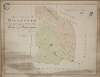
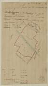
A map of the lands of Killaster situate in the barony of Castlereagh and County of Roscommon. Surveyed for the Revd. Dean French. By John Conolly. June 1826. Table of reference showing tenants and acreage of holdings. Scale 20 perches to an inch.
Map
Main Creator:
Connolly,
John
, fl. 1826, surveyor
Language:
English
Format:
Map
In collection:
Longfield Map Collection
Published / Created
[June 1826]
Notes
Physical description: 1 map Geographic Coverage: Bar...
Call Number:
Loading...
Located:
Loading...
A survey of part of the Lands of Blanchardstown in the County of Dublin - Parish & Barony of Castleknock, the Estate of Peter Locke Esq. by John Longfield 1830. Scale 10 Perches to an Inch
Map
Main Creator:
Longfield,
John
, ca. 1775-1833, surveyor
Language:
English
Format:
Map
In collection:
Longfield Map Collection
Published / Created
[1830]
Notes
Physical description: 1 map Geographic Coverage: Par...
Call Number:
Loading...
Located:
Loading...
A map of part of the Lands of Ashtown, near the 11th lock of the Royal Canal in the Co Dublin. Surveyed by J.L. Scale 100 Feet to an Inch
Map
Main Creator:
Longfield,
John
, ca. 1775-1833, surveyor
Language:
English
Format:
Map
In collection:
Longfield Map Collection
Published / Created
[between 1795 and 1833]
Notes
Physical description: 1 map Geographic Coverage: Bar...
Call Number:
Loading...
Located:
Loading...
A map of part of the Glebe lands of Kilcullen in the County of Kildare, granted by the Rev. Thomas Brownrigg Chancellor of the cathedral church of the Holy and Undivided Trinity Dublin to the Rev. J. Hardy and his successors as an additional Glebe to the parish of Killcullen. Surveyed by John Longfield 1822. Scale 20 perches to an inch. Table of reference showing tenants names & area of holdings.
Map
Main Creator:
Longfield,
John
, ca. 1775-1833, surveyor
Language:
English
Format:
Map
In collection:
Longfield Map Collection
Published / Created
[1822]
Notes
Physical description: 1 map Geographic Coverage: Par...
Call Number:
Loading...
Located:
Loading...
A map of part of the lands at Kelshamore in the barony of Talbotstown Upper and County of Wicklow the estate of the Rev Sir S.S. Hutchinson, Bart let to Edward Flynn, Senior. Surveyed by John Longfield 1813. Scale 20 perches to an inch.
Map
Main Creator:
Longfield,
John
, ca. 1775-1833, surveyor
Language:
English
Format:
Map
In collection:
Longfield Map Collection
Published / Created
[1813]
Notes
Physical description: 1 map Geographic Coverage: Bar...
Call Number:
Loading...
Located:
Loading...
A map of part of the lands of Kelshamore in the barony of Talbotstown Upper and County of Wicklow the estate of the Rev. Sir Samuel Synge Hutchinson, Bart let to Edward Flynn, Junior. Surveyed by John Longfield 1813. Scale 20 perches to an inch.
Map
Main Creator:
Longfield,
John
, ca. 1775-1833, surveyor
Language:
English
Format:
Map
In collection:
Longfield Map Collection
Published / Created
[1813]
Notes
Physical description: 1 map Geographic Coverage: Bar...
Call Number:
Loading...
Located:
Loading...
A map of part of the Lands of Finglass in the Co Dublin - Surveyed for John Bayly Esq. by J.L. 1818. Scale 10 Perches to an Inch
Map
Main Creator:
Longfield,
John
, ca. 1775-1833, surveyor
Language:
English
Format:
Map
In collection:
Longfield Map Collection
Published / Created
[1818]
Notes
Physical description: 1 map Geographic Coverage: Bar...
Call Number:
Loading...
Located:
Loading...
A map of Killishee [Killashee] Soordlestown [Swordlestown] etc, in the barony of Naas and County of Kildare belonging to Robert Graydon. By John Brownrigg 1777. Names of tenants shown on some holdings.
Map
Main Creator:
Brownrigg,
John
, ca. 1748-1838, surveyor
Language:
English
Format:
Map
In collection:
Longfield Map Collection
Published / Created
[1777]
Notes
Physical description: 1 map Geographic Coverage: Bar...
Call Number:
Loading...
Located:
Loading...
A map of a piece of ground [now a plantation] adjoining the concerns of John Cassidy in Monasterevin, the estate of Charles Marquis of Drogheda. Surveyed September 1806. By J.L. Scale 42 feet to an inch.
Map
Main Creator:
Longfield,
John
, ca. 1775-1833, surveyor
Language:
English
Format:
Map
In collection:
Longfield Map Collection
Published / Created
[1806]
Notes
Physical description: 1 map Geographic Coverage: Bar...
Call Number:
Loading...
Located:
Loading...
A map of part of the lands of Ballyboggan in the barony of Moyfenrath and County of Meath part of the estate of the Marquis of Lansdowne. By J. L. 1824. Names of tenants and acreage of holdings shown.
Map
Main Creator:
Longfield,
John
, ca. 1775-1833, surveyor
Language:
English
Format:
Map
In collection:
Longfield Map Collection
Published / Created
[1824]
Notes
Physical description: 1 map Geographic Coverage: Bar...
Call Number:
Loading...
Located:
Loading...
A map of part of Peafield in the Barony of Coolock & County of Dublin, the Estate of [illegible] Bever Esq. Survey'd by John Brownrigg 1795. Scale 20 Perches to an Inch
Map
Main Creator:
Brownrigg,
John
, ca. 1748-1838, surveyor
Language:
English
Format:
Map
In collection:
Longfield Map Collection
Published / Created
[1795]
Notes
Physical description: 1 map Geographic Coverage: Bar...
Call Number:
Loading...
Located:
Loading...
A map of Ballinealoe and Williamstown in the barony of Fore and County of Westmeath, the estate of Thomas Smyth. By J.B. March 1781.
Map
Main Creator:
Brownrigg,
John
, ca. 1748-1838, surveyor
Language:
English
Format:
Map
In collection:
Longfield Map Collection
Published / Created
[1781]
Notes
Inset map: "A map of several lots of ground lying bet...
Call Number:
Loading...
Located:
Loading...
A survey of part of the Lands of Ballyboggan in the Parish of Finglas & County of Dublin the Estate of the Dean & Chapter of Christ Church let to the Trustees of Morgans Charity Schools. Surveyed by J.L. 1815
Map
Main Creator:
Longfield,
John
, ca. 1775-1833, surveyor
Language:
English
Format:
Map
In collection:
Longfield Map Collection
Published / Created
[1815]
Notes
Physical description: 1 map Geographic Coverage: Par...
Call Number:
Loading...
Located:
Loading...
A map of Part of Castleknock. Surveyed by J. Longfield
Map
Main Creator:
Longfield,
John
, ca. 1775-1833, surveyor
Language:
English
Format:
Map
In collection:
Longfield Map Collection
Published / Created
[between 1795 and 1833]
Notes
Physical description: 1 map Geographic Coverage: Bar...
Call Number:
Loading...
Located:
Loading...
Section of boundary stream between Ballybin and Cookstown in the County of Meath showing the proposed new sinking of same to drain the farms of Messrs. Rooney, Moran, Babbett and Kconan done by order of Robert Franks March 183[1] By J.L. Longitudinal scale 20 perches to an inch. Height scale 20 feet to an inch.
Map
Main Creator:
Longfield,
John
, ca. 1775-1833, surveyor
Language:
English
Format:
Map
In collection:
Longfield Map Collection
Published / Created
[March 1831]
Notes
Physical description: 1 map Geographic Coverage: Bar...
Call Number:
Loading...
Located:
Loading...
A survey of part of the lands of Shanahoe and Killeany in the barony of Maryborough West and Queen's [Leix] County purchased by H.H. Bawne Surveyed by J.L. 1815. Names of tenants & acreage of holdings shown.
Map
Main Creator:
Longfield,
John
, ca. 1775-1833, surveyor
Language:
English
Format:
Map
In collection:
Longfield Map Collection
Published / Created
[1815]
Notes
Physical description: 1 map Geographic Coverage: Cou...
Call Number:
Loading...
Located:
Loading...
A map of part of the lands of Cloghernagh [Patrickstown?] in the barony of Demifore and County Meath part of the estate of Lady Piers Marley let to Bryan Brady. By J.L. 180[1?].
Map
Main Creator:
Longfield,
John
, ca. 1775-1833, surveyor
Language:
English
Format:
Map
In collection:
Longfield Map Collection
Published / Created
[1801]
Notes
Physical description: 1 map Geographic Coverage: Bar...
Call Number:
Loading...
Located:
Loading...
A survey of the demense of Killdalkey [Kildalkey] in the parish of Killdalkey [Kildalkey] barony of Lune and County of Meath [Surveyed by J.B.] May 7th 1772 for Robert Walle.
Map
Main Creator:
Brownrigg,
John
, ca. 1748-1838, surveyor
Language:
English
Format:
Map
In collection:
Longfield Map Collection
Published / Created
[May 07 1772]
Notes
Physical description: 1 map Geographic Coverage: Par...
Call Number:
Loading...
Located:
Loading...
A Survey of the Lands of Edengully alias Edendewgallen in the Barony of Cloonkee & Co. Cavan - the Estate of Mr. Smyth, by J.L. 1816
Map
Main Creator:
Longfield,
John
, ca. 1775-1833, surveyor
Language:
English
Format:
Map
In collection:
Longfield Map Collection
Published / Created
[1816]
Notes
Physical description: 1 map Geographic Coverage: Par...
Call Number:
Loading...
Located:
Loading...
A map of several parcels of ground call'd the Bell lands of Kilcullen, in the County of Kildare part of the estate of the Prebendaries & Vicars of Christ Church Dublin let to [illegible]. Survey'd by J.L. 1809. Table of reference showing tenants names & area of holdings.
Map
Main Creator:
Longfield,
John
, ca. 1775-1833, surveyor
Language:
English
Format:
Map
In collection:
Longfield Map Collection
Published / Created
[1809]
Notes
Physical description: 1 map Geographic Coverage: Bar...
Call Number:
Loading...
Located:
Loading...
1
2
3
4
5
6
7
8
9
10
11
Next
13
Get RSS Feed
Email this Search
History
Narrow Search
Clear Filter
Digitised
Remove Filters
Clear Filter
Genre: Maps, Manuscript
Clear Filter
Subject: Administration of estates
Format
255
Map
Online Availability
Digitised
Published / Created
From:
To:
Subject
Administration of estates
255
Boundaries (Estates)
255
Land tenure
255
Land use surveys
53
History
9
Administration of Estates
Author
177
Longfield, John, ca. 1775-1833, surveyor
46
Brownrigg, John, ca. 1748-1838, surveyor
14
Brownrigg & Co., fl. 1801-1809, surveyors
4
Brownrigg, Longfield and Murray, fl. 1799-ca. 1805, surveyors
4
Scalé, Brownrigg & Sherrard, fl. 1774-1778, surveyors
1
Balfe, M., fl. 1821, surveyor
more ...
1
Bell, John (I and II), fl. 1721-1820
1
Browne, John, fl. 1788-ca. 1807, surveyor
1
Byrne, John, fl. 1789-1828, surveyor
1
Connolly, John, fl. 1826, surveyor
1
Logan, John, fl. 1827-1846, surveyor
1
Longfield, William, fl. 1825-ca. 1870, surveyor
1
Netterville, John, fl. 1747-1768, surveyor
1
O'Brien, John, fl. 1784-1820, surveyor
1
Roe, John, fl. 1793-1824, surveyor
see all ...
less ...
Collections
255
Longfield Map Collection
Language
255
English
Genre
255
Manuscript maps
Maps, Manuscript
53
Early works to 1800
Era
53
18th century
Region
251
Ireland
75
Dublin (Ireland : County)
74
Dublin (County)
48
Meath
48
Meath (Ireland)
46
Kildare (County)
more ...
46
Kildare (Ireland : County)
39
Coolock (Barony)
17
Offaly West (Barony)
16
Castleknock (Barony)
11
Balrothery (Barony)
11
Westmeath
11
Westmeath (Ireland)
11
Wicklow (County)
11
Wicklow (Ireland : County)
10
Roscommon (County)
10
Roscommon (Ireland : County)
9
Duleek Upper (Barony)
9
Laois
9
Laois (Ireland)
7
Moyfenrath Upper (Barony)
7
Ratoath (Barony)
6
Fore (Barony)
6
Kilkenny (County)
6
Kilkenny (Ireland : County)
6
Longford (County)
6
Longford (Ireland : County)
6
Offaly
6
Offaly (Ireland)
5
Dublin (Ireland)
see all ...
less ...
Loading...


![A map of Killishee [Killashee] Soordlestown [Swordlestown] etc, in the barony of Naas and County of Kildare belonging to Robert Graydon. By John Brownrigg 1777. Names of tenants shown on some holdings.](/IIIF/000310000/000302012/vtls000302012_001.jp2/full/100,/0/default.jpg)
![A map of a piece of ground [now a plantation] adjoining the concerns of John Cassidy in Monasterevin, the estate of Charles Marquis of Drogheda. Surveyed September 1806. By J.L. Scale 42 feet to an inch.](/IIIF/000310000/000302176/vtls000302176_001.jp2/full/100,/0/default.jpg)

![A map of part of Peafield in the Barony of Coolock & County of Dublin, the Estate of [illegible] Bever Esq. Survey'd by John Brownrigg 1795. Scale 20 Perches to an Inch](/IIIF/000310000/000301182/vtls000301182_001.jp2/full/100,/0/default.jpg)

![Section of boundary stream between Ballybin and Cookstown in the County of Meath showing the proposed new sinking of same to drain the farms of Messrs. Rooney, Moran, Babbett and Kconan done by order of Robert Franks March 183[1] By J.L. Longitudinal scale 20 perches to an inch. Height scale 20 feet to an inch.](/IIIF/000310000/000301845/vtls000301845_001.jp2/full/100,/0/default.jpg)
![A survey of part of the lands of Shanahoe and Killeany in the barony of Maryborough West and Queen's [Leix] County purchased by H.H. Bawne Surveyed by J.L. 1815. Names of tenants & acreage of holdings shown.](/IIIF/000310000/000302379/vtls000302379_001.jp2/full/100,/0/default.jpg)
![A map of part of the lands of Cloghernagh [Patrickstown?] in the barony of Demifore and County Meath part of the estate of Lady Piers Marley let to Bryan Brady. By J.L. 180[1?].](/IIIF/000310000/000301764/vtls000301764_001.jp2/full/100,/0/default.jpg)
![A survey of the demense of Killdalkey [Kildalkey] in the parish of Killdalkey [Kildalkey] barony of Lune and County of Meath [Surveyed by J.B.] May 7th 1772 for Robert Walle.](/IIIF/000310000/000301788/vtls000301788_001.jp2/full/100,/0/default.jpg)

![A map of several parcels of ground call'd the Bell lands of Kilcullen, in the County of Kildare part of the estate of the Prebendaries & Vicars of Christ Church Dublin let to [illegible]. Survey'd by J.L. 1809. Table of reference showing tenants names & area of holdings.](/IIIF/000310000/000302001/vtls000302001_001.jp2/full/100,/0/default.jpg)