Showing
1 - 11
results of
11
for search '
Taylor, T.
'
Skip to content
Toggle navigation
NLI Website
- Catalogue -
English
Gaeilge
Home
Help
Advanced Search
Browse
Orders
Ask a Librarian
Language
English
Gaeilge
All Fields
Title
Author
Subject
Call Number
ISBN/ISSN
Publisher
Coordinates
Search digitised content only
FIND
Author
Taylor, T.
Results
Showing
1 - 11
results of
11
for search '
Taylor, T.
'
, query time: 0.05s
List
Grid
Sort
Relevance
Newest First
Oldest First
Call Number
Author
Title
Map of the lands of Clegarrow situate in the County of Meath
1852
Map
Main Creator:
Taylor
, George
Language:
English
Format:
Map
In collection:
Conyngham Papers, 1614-1935.
Published / Created
1852
Notes
General note on map: A cover note accompanies the map...
Call Number:
Loading...
Located:
Loading...
View Context
[Map of] Currea, Davitt
1831
Map
Main Creator:
Taylor
, George Surveyor
Language:
English
Format:
Map
In collection:
Westport Estate papers, 1540-1993.
Published / Created
1831
Notes
Map of Currea, County Mayo, Province of Connacht, Ire...
Call Number:
Loading...
Located:
Loading...
View Context
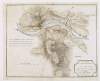
A map of Enniscorthy and Vinegar Hill, where the rebels were posted previous to the action on the 21st of June 1798, by Alexander Taylor, Captain in His Majesties Royal Engineers,
[1798?]
Map
Main Creator:
Taylor
, Alexander, fl. 1766-1830
Language:
English
Format:
Map
Published / Created
[1798?]
Notes
Above the scale bar is written 'Scale of 1/2 a mile'...
Call Number:
Loading...
Located:
Loading...
Maps of the roads of Ireland /
Map
Main Creator:
Taylor
, George (Geographer), active 1778.
Language:
English
Format:
Map
Published / Created
1969.
Notes
Facsim. of the 2d ed., London and Dublin, 1783. Orig...
Call Number:
Loading...
Located:
Loading...
Taylor & Skinner's survey and maps of the roads of North Britain or Scotland /
Map
Main Creator:
Taylor
, George (Geographer), active 1778.
Language:
English
Format:
Map
Published / Created
1776.
Notes
Survey made 1775. Dedicated: To his Grace John Duke...
Call Number:
Loading...
Located:
Loading...
A map of the county of Kildare /
1783.
Map
Main Creator:
Taylor
, Alexander, fl. 1766-1830
Language:
English
Format:
Map
Published / Created
1983.
Notes
Reprint of original 1783 map. Scale 1": 69.5 mls. Ph...
Call Number:
Loading...
Located:
Loading...
A new map of Ireland having the great features of the country described in a manner highly expressive and the distances between the towns and stages marked in miles and furlongs for the use of travellers /
1793.
Map
Main Creator:
Taylor
, Alexander, fl. 1766-1830
Language:
English
Format:
Map
Published / Created
January 1st 1793.
Notes
With note "To his Excellency John, Earl of Westmorela...
Call Number:
Loading...
Located:
Loading...
Atlas of the County Waterford Estates of Sir John Kennedy Bart. /
1844.
Map
Main Creator:
Taylor
, George, fl. 1841-1850, surveyor, engraver
Language:
English
Format:
Map
Published / Created
1844.
Notes
Oblong atlas folio, bound in contemporary full brown...
Contributors:
“
...
Taylor
, Arthur, fl. 1845-1846, surveyor, engraver...
”
Call Number:
Loading...
Located:
Loading...
Plans and drawings for new turbine and pumphouse to be built at Headfort, Kells, County Meath /
December 1870.
Map
Main Creator:
Roberts, Samuel Ussher, 1821-1900
Language:
English
Format:
Map
Published / Created
December 1870.
Notes
Hand-coloured plans. Signed by Samuel Ussher Roberts....
Contributors:
“
...Headfort, Thomas
Taylor
, Marquis of, 1822-1894...
”
Call Number:
Loading...
Located:
Loading...
Maps and plans of Headfort estate,
1814-1889.
Map
Main Creator:
Headfort, Marquesses of
Language:
English
Format:
Map
Published / Created
1814-1889.
Notes
Physical description: 6 items (folded). Geographic Co...
Contributors:
“
...Headfort, Thomas
Taylor
, Marquis of, 1822-1894...
”
Call Number:
Loading...
Located:
Loading...
Geology of the country around Droitwich, Abberley and Kidderminster
Map
Main Creator:
Mitchell, G. H. (George Hoole), 1902-
Language:
English
Format:
Map
Published / Created
1961.
Notes
At head of title: Department of Scientific and Indust...
Contributors:
“
...
Taylor
, James Haward....
”
Call Number:
Loading...
Located:
Loading...
Get RSS Feed
Email this Search
History
Narrow Search
Digitised
Remove Filters
Clear Filter
Format: Map
Format
Map
Online Availability
10
Not Digitised
1
Digitised
Published / Created
From:
To:
Subject
4
Maps
4
Maps, Manuscript
2
Administration of Estates
2
Architecture
2
Cartography
2
Estates
more ...
2
Land use surveys
2
Maps and Surveys
2
Real property
2
Roads
2
Surveyors
1
Campaigns
1
Cities and towns
1
Geology
1
History
1
Vinegar Hill, Battle of, Wexford, Ireland, 1798
1
Waterworks
see all ...
less ...
Author
3
Taylor, Alexander, fl. 1766-1830
2
Taylor, George (Geographer), active 1778
1
Headfort, Marquesses of
1
Mitchell, G. H. (George Hoole), 1902-
1
Roberts, Samuel Ussher, 1821-1900
1
Taylor, George
more ...
1
Taylor, George Surveyor
1
Taylor, George, fl. 1841-1850, surveyor, engraver
see all ...
less ...
Collections
1
Conyngham Papers, 1614-1935.
1
Westport Estate papers, 1540-1993.
Language
11
English
Genre
5
Maps
3
Early works to 1800
2
Designs and plans
2
Facsimiles
2
Manuscript maps
2
Maps, Manuscript
Era
1
Rebellion of 1798
Region
9
Ireland
1
Cavan (County)
1
Cavan (Ireland : County)
1
England
1
Herefordshire
1
Kells (Meath)
more ...
1
Kildare (County)
1
Kildare (Ireland : County)
1
Meath
1
Meath (Ireland)
1
Ramor, Lough
1
Scotland
1
Shropshire
1
Waterford (County)
1
Waterford (Ireland : County)
1
Wexford (Ireland : County)
1
Worcestershire
see all ...
less ...
Loading...