Showing
1 - 4
results of
4
for search '
Brownrigg, Longfield and Murray, fl. 1799-ca. 1805, surveyors
'
Skip to content
Toggle navigation
NLI Website
- Catalogue -
English
Gaeilge
Home
Help
Advanced Search
Browse
Orders
Ask a Librarian
Language
English
Gaeilge
All Fields
Title
Author
Subject
Call Number
ISBN/ISSN
Publisher
Coordinates
Search digitised content only
FIND
Author
Brownrigg, Longfield and Murray, fl. 1799-ca. 1805, surveyors
Results
Showing
1 - 4
results of
4
for search '
Brownrigg, Longfield and Murray, fl. 1799-ca. 1805, surveyors
'
, query time: 0.03s
List
Grid
Sort
Relevance
Newest First
Oldest First
Call Number
Author
Title
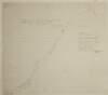
A map of the proposed line of Road from Hilltown to Kilkeel in the County of Down. Survey by Brownrigg, Longfield & Murray. 1801
Map
Main Creator:
Brownrigg
,
Longfield
and
Murray
,
fl
.
1799
-
ca
.
1805
,
surveyors
Language:
English
Format:
Map
In collection:
Longfield Map Collection
Published / Created
[1801]
Notes
Physical description: 1 map Geographic Coverage: Bar...
Call Number:
Loading...
Located:
Loading...
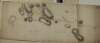
A map of the several estates of John Hearn and Henry Trant at Carrowreagh ... and Lissalway situate in the County of Roscommon and barony of Castlereagh. Surveyed by Brownrigg Longfield and Murray. 1802. Scale 20 perches to an inch. Names of tenants and acreage of holdings shown.
Map
Main Creator:
Brownrigg
,
Longfield
and
Murray
,
fl
.
1799
-
ca
.
1805
,
surveyors
Language:
English
Format:
Map
In collection:
Longfield Map Collection
Published / Created
[1802]
Notes
Physical description: 1 map Geographic Coverage: Bar...
Call Number:
Loading...
Located:
Loading...
A map of the demense of Bellegrove and Rathronshin Queens [Leix] County. Surveyed by Brownrigg Longfield & Murray. Scale 20 perches to an inch. Table of reference showing contents & acreage & R. Allen's farm.
Map
Main Creator:
Brownrigg
,
Longfield
and
Murray
,
fl
.
1799
-
ca
.
1805
,
surveyors
Language:
English
Format:
Map
In collection:
Longfield Map Collection
Published / Created
[between 1799 and 1805]
Notes
Physical description: 1 map Geographic Coverage: Bar...
Call Number:
Loading...
Located:
Loading...
A map of an intended line of new Road between the Towns of Mallahide & Swords in the County of Dublin. Survey'd by Brownrigg Longfield & Murray. Scale 20 Perches to an Inch
Map
Main Creator:
Brownrigg
,
Longfield
and
Murray
,
fl
.
1799
-
ca
.
1805
,
surveyors
Language:
English
Format:
Map
In collection:
Longfield Map Collection
Published / Created
[between 1799 and 1805]
Notes
Physical description: 1 map Geographic Coverage: Bar...
Call Number:
Loading...
Located:
Loading...
Get RSS Feed
Email this Search
History
Narrow Search
Clear Filter
Digitised
Format
4
Map
Online Availability
Digitised
Published / Created
From:
To:
Subject
4
Administration of estates
4
Boundaries (Estates)
4
Land tenure
4
Land use surveys
Author
4
Brownrigg, Longfield and Murray, fl. 1799-ca. 1805, surveyors
Collections
4
Longfield Map Collection
Language
4
English
Genre
4
Manuscript maps
4
Maps, Manuscript
Region
3
Ireland
1
Castlereagh (Barony)
1
Coolock (Barony)
1
Down (County)
1
Down (Northern Ireland : County)
1
Dublin (County)
more ...
1
Dublin (Ireland : County)
1
Iveagh (Barony)
1
Laois
1
Laois (Ireland)
1
Northern Ireland
1
Portnahinch (Barony)
1
Roscommon (County)
1
Roscommon (Ireland : County)
see all ...
less ...
Loading...
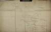
![A map of the demense of Bellegrove and Rathronshin Queens [Leix] County. Surveyed by Brownrigg Longfield & Murray. Scale 20 perches to an inch. Table of reference showing contents & acreage & R. Allen's farm.](/IIIF/000310000/000302386/vtls000302386_001.jp2/full/100,/0/default.jpg)